Bigga 1-50,000 NSW Topographic Map
$16.95 – $31.95
Description:
Bigga 8729-n 1-25,000 scale NSW Topographical map is used for Walking, 4WD, Fishing, Camping, Motorcycle, both On and Off Road, Gold Prospecting and for those simply going for a family weekend drive.
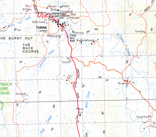
Topographical maps show not only Contours of the Terrain but also Walking Tracks, Sealed and Unsealed Roads, Rivers, Creeks, Lakes, Historical Point of Interest, Old Mine Sites and National and State Park areas.
 We can Now LAMINATE and fold your map for $12.00. Just click on the image and add to the Trolley
Locations within this Map
Yarraman Yarra The Willows Noorla Upper Montana Hillandale Wrens Nest Wyoming Melrose Cooks Vale Bundeena Sandy Creek Pine Hill Yewrangara The Alps Paloma Strathaird Dryburgh Fairfield Willdamar Snowy Mount Rosedale Glenelg Burwood Wattle Grove Markdale Boonara Wongaburra Kings Vale Wondokai Willow Dam Wongalea Mycumbene Little Hill Taloa Apple Tree Creek Back Creek Asylum Creek Apple Tree Flat Adams Lane Creek Abercrombie River Back Gully Battery Crossing Bears Creek Bears Gully Big Flat Creek Bigga Bigga Cemetery Bigga Creek Bigga Oval Bigga Public School Bigga Sports Oval Big Magpie Hill The Big Meadow Big Meadow Flat Big Waterhole Big Waterholes Billy Blue Billy Blue Mountain Bocannecals Springs Blazes Old Station Blanket Flat Gully Blanket Gully Blanket Flat Blanket Flat Creek Black Springs The Black Springs The Black Rock Black Rock Black Mares Flat Blackmans Creek Blackman Blocker Creek Bingham Gully Bingham Creek Bowlen Creek Bramah Creek Branch of Kangallolah Arm Of Tunea Creek Branch of Lachlan River Breakfast Creek Callaba Creek Carr Saddle Cluney Creek Coates Creek Compass Ridge Cooks Vale Bald Hill Cooks Vale Creek Cordillera Mount Costigan Crokers Creek Crooked Corner Cuddyong Cuddyong Creek Deadmans Creek Deep Creek Fell Timber Gully Fiddlers Elbow Five Mile Flat Five Mile Tree Public School Foggs Flat Giblets Mountain Gibsons Flat Creek Gillindich Glengarry Glengarry Creek Goulburn Flat Creek Gum Gully Hearnes Gully Homeward Bound Gully Joes Creek Junction Point Kangaloolah Kangaroo Creek Keverstone Keverstone State Forest Callabah Creek Cemetery At Tuena Compass Compass Range The Compass Range Deadmas Creek and Boorungullen Chain of Ponds Eastern Branch of Sandy Creek Fell Timber Creek The Five Mile Flat Flowerburn General Cemetery Gibsons Gibsons or Big Flat Creek Gillendich Point Gillindich Point Glengarry Crossing Good Water Hole Gum Creek Hearness Branch J.M.B. Creek Kangaloolah Creek Kangaloolah Arm of Tuena Creek King Wattle Creek Lachlan River Limerick Limestone Creek Little Redbank Creek Little Redbank Gully Long Hollow Creek The Long Hollow Meadow Flat Creek Meglo Meglo Creek Meglo Swamp Memunday Creek Middle Creek Mulgowrie Mulgowrie Creek Mutbilly Creek Nuggetty Creek Nuggetty Gully Oakey Creek Oaky Creek Oaky Gully Peelwood Peelwood Cemetery Peelwood Creek Penny Royal Flat Perrys Creek Perrys Flat Perrys or Limestone Creek Picker Creek Razor Back Range Razor Back Ridge Reedy Creek Reedy Gully Reids Flat Reids Flat Public School Reids Flat Showground Rocky Waterhole The Saddle Saltwater Creek Single Tree Sletes Creek Small Running Creek Smigging Hole Creek Smilers Hollow Smilers Hollow Creek Snowy Mountain Sow and Pigs Creek Springy Creek Spring Creek Spring Flat Stoney Creek Stony Creek Supper Creek Surveyors Flat Taylors Creek Thalaba Creek The Wrens Nest Third Flat Tuena Tuena Cemetery Tuena Creek Tuena Primary School Tuena Public School Upper Tuena Victoria Flat Wangalo Wangalo Flat Wattle Creek Wattle Flat The Wattle Flat Wells Wells Creek Mount Wells Western Branch Western Branch of Limestone Creek Whick Whack Wrens Nest Creek Yarraman Creek Dinner Hill Dirt Hole Flats Dog Trap Creek Dryburgh Creek Burnt Hut Creek Burnt Hut Gully Burwood Creek Bushranger Gully Razorback Nature Reserve Sheck Webster Lookout Goonoongla Creek Hooks Corner Western Branch of Blackmans Creek Keverstone Creek Jay and Bee Creek Bright Creek Eastern Branch of Blackmans Creek Bobs Corner Red Hill Sentry Box The Burnt Hut The Race Course Yewrangara Springs Magpie Mount Pleasant Keverstone National Park Isabella River Kangaloolah Arm Grahams Creek Numby Collaba Creek Crookwell River
| Scale: | 1:50000 |
| Latitude Range: | 34° 0.0′ S – 34° 15.0′ S |
| Longitude Range: | 149° 0.0′ E – 149° 30.0′ E |
| Datum: | GDA 94 |
| Approx Print Size: | 0.56m X 1.11m |
| Publication Date: | 2013 |


