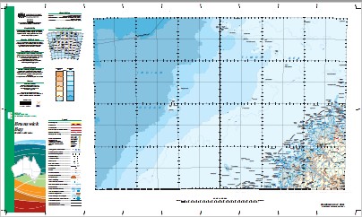
Brunswick Bay 1-1,000,000 Topographic Map Geoscience Australia
$16.95 – $28.95
Description:
Brunswick Bay 1-1,000,000 Topographic Map Geoscience Australia
1: 1 Million General Reference Topographic Map Print on Demand
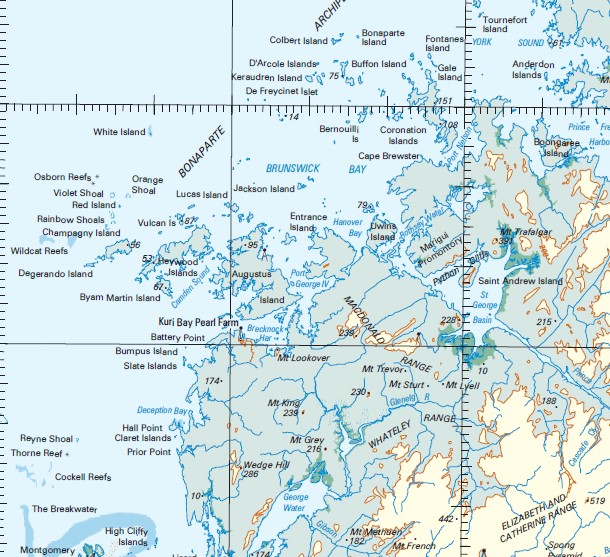
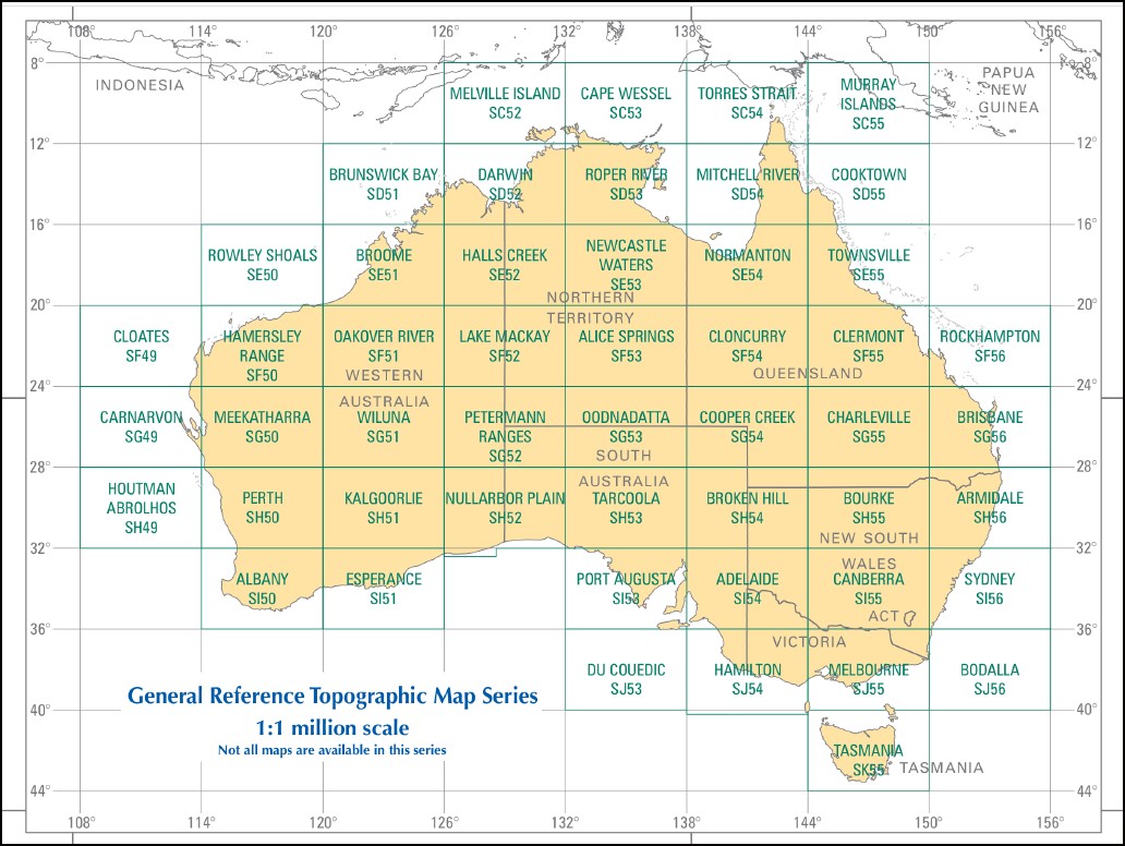
This map is part of a series which comprises 50 maps which covers the whole of Australia at a scale of 1:1 000 000 (1cm on a map represents 10km on the ground). Each standard map covers an area of 6 degrees longitude by 4 degrees latitude or about 590 kilometres east to west and about 440 kilometres from north to south. These maps depict natural and constructed features including transport infrastructure (roads, railway airports), hydrography, contours, hypsometric and bathymetric layers, localities and some administrative boundaries, making this a useful general reference map.
Ashmore Reef Heywood Shoal Holothuria Banks Barracouta Reef Barracouta Shoal Beagle Reef Echuca Reef Echuca Shoal Lynher Reef Mavis Reef Scott Plateau Scott Reef Seringapatam Reef Vukan Shoal Vulcan Reef Vulcan Shoal Woodbine Bank 7 Mile Creek Aatjatayi Acasta Island Adele Island Adele Island Shoal Adenotricha Creek Adieu Point Admiralty Gulf Agu Ngalangalangali Airfield Swamp Albert Islands Albert Reef Andandilia Anderdon Islands Argunalang Nalang Ngari Arlu Mai Yordu Association Inlet Atrina Island Attack Island Atys Island Augereau Island Augustus Island Augustus Water Balami Ridge Barlee Impediment Barron Banks Bassett-Smith Shoal Bat Island Battery Point Baudin Island Bernouilli Island Berthier Island Berthoud Island Biddles Rock Bigge Island Bigge Point Bignell Island Bird Island Bishop Island Black Rocks Bluff Hill Blyxa Creek Bonaparte Archipelago Bonaparte Island Booby Island Boomerang Bay Boongaree Island Branch Island Brecknock Harbour Brown Inlet Browne Island Browse Island Brue Reef Brunei Bay Brunswick Bay Buckland Point Buffon Island Bullara Rock Bumpus Island Bundolgwa Creek Bushfire Hill Byam Martin Island Calliance Point Calliance Reef Camden Harbour Camden Peninsula Camden Sound Camp Creek Cape Brewster Cape Chateaurenaud Cape Mollien Cape Pond Cape Torrens Cape Voltaire Cape Wellington Capstan Island Careening Bay Careening Island Carlia Island Cartier Island Cascade Creek Cassini Island Caswell Island Centre Rock Challis Rocks Champagny Island Champagny Islands Championet Island Chanake Churchill Reef Claret Islands Cleghorn Island Clerk Island Cockell Bank Cockell Reefs Coffee Royal Colbert Island Combe Hill Island Combe Island Combe Rock Commerson Island Condillac Island Conical Hill Conway Island Corneille Island Coronation Island Coronation Islands Corvisart Island Cotthurst Rock Cotton Island Crabbe Island Crystal Creek Crystal Head Cymo Island D’Aguesseau Island D’Arcole Islands Darcy Island D’Artagnan Shoal Davidson Point De Freycinet Islet Deception Bay Degerando Island Denman Shoal Desaix Islands Descartes Island Desfontaines Island Dice Rock Didja Dingo Reef Djarumu Island Djarworrada Community Don Island Donkins Hill Duguesclin Island Dunedale Creek East Island East Montalivet Island Easton Edeys Creek Elizabeth and Catherine Range Ena Island Enid Falls Entrance Island Etisus Island Eugene Mcdermott Shoal Eyre Rock Fenelon Island Fenelon Passage Fern Gully Fish River Flat Island Fly Shoal Fontanes Island Forbin Island Forrest Rock Fox Shoal Fraser Inlet Freshwater Cove Froggart Island Frost Shoal Fury Rock Gabriel Island Gaimard Island Gairdner River Gale Island Gandalwolgari Hill Gandjal Creek Gap Island Garimbu Creek Gariyeli Creek George Water Gibbings Reefs Gibson Creek Gibson Point Gill Island Glauert Creek Glauert Island Glauert Lagoon Glenelg River Granite Island Green Island Greville Island Grey Island Gundarara Creek Gurrbirri Creek Hale Island Halfway Bay Hall Point Hampton Downs Hanover Bay Hardy Point Hawick Island Hecla Island Hedley Island Heritage Reef Heywood Island Heywood Islands High Bluff High Cliffy Islands Hope Point Hull Bank Hummock Island Hunter River Imorogu Tabletop Ingram Reef Institut Islands Iradi Hill Iredale Island Ivy Cove Ivy Rock Jackson Island Jamieson Reef Jangawarnanya Creek Jangawarnanya Inlet Jolialgum Creek Jungulu Island Jussieu Island Kandiwal Community Kankanmengarri Island Kannamatju Island Kartja Island Katers Island Keraudren Island Kid Island Kidney Island Kimberley Coastal Camp King Cascade King Island Kingsmill Islands Krait Bay Kumpanapirra Creek Kunmunya Kunmunya Hill Kuntjumal Kutangari Island Kuri Bay Kuringna Lafontaine Island Lagrange Island Lalirimir Spring Lamarck Island Lammas Island Langgi Laplace Island Laseron Island Latirus Island Lauangi Island Lavoisier Island Lawley Hill Lawley River Lee Rock Leichardt Creek Lena Reef Lizard Island Long Reef Lorikeet Shoal Lorinna Shoal Low Rock Low Rocks Low Rocks Nature Reserve Lucas Island Lulim Island Lushington Valley Mably Island Macdonald Range Macgregor Point Macleay Island Macleay Islands Maitland Bay Malcolm Island Malubirindji Cave Mangrove Point Manning Peak Maret Island Maret Islands Mariawala Falls Marigui Gorge Marigui Promontory Marndungum Island Marun Massey Creek Matann Bluff Mcculloch Island Mcintyre Island Mcrae River Mertens Creek Mertens Falls Miawaja Island Mictyis Island Middle Island Midway Island Mindjau Creek Mitchell Falls Mitchell Plateau Mitchell River Moliere Island Momorinyam Creek Monge Island Montague Sound Montesquieu Islands Montgomery Islands Montgomery Reef Moon Rock Moran River Mosquito Flats Mount Agnes Mount Allen Mount Anderdon Mount Batten Mount Bomford Mount Bradshaw Mount Brookes Mount Double Cone Mount Eyre Mount French Mount Fyfe Mount Grey Mount Hann Mount Hickey Mount King Mount Knight Mount Lookover Mount Lyell Mount Mccrann Mount Methuen Mount Russ Mount Sturt Mount Trafalgar Mount Trevor Mount Waterloo Mount York Mudge Bay Mulamulonya Crossing Munster Water Murrangingi Island Murrara Island Museums Island Mushroom Rocks Myres Island Naturalists Beach Naturalists Island Needle Rock Ngalanguru Island Nglayu Island Niblock Rocks Nicolle Reef Nimbanguray Hills Ninintjitji Norgor Inlet North Breaker North Entrance Numanbu Island Numardin Hill Nungunambulu Galuru Creek Nyimandum Okenia Island Oliver Island Oliver Rock One Tree Island Orange Shoal Osborn Reefs Oyster Rock Oyster Rock Passage Pantijan Pantijan Community Parin Peninsula Parry Island Pascal Island Patricia Island Penguin Shoal Perseverance Inlet Pickering Point Pinadhy Falls Pitta Creek Point Augustus Port George Iv Port Nelson Port Warrender Prince Frederick Harbour Prince Regent Nature Reserve Prince Regent River Prince Shoal Princess May Ranges Prior Point Prudhoe Island Prudhoe Islands Prudhoe Rocks Purrungku Island Purulba Pyrene Island Python Cliffs Quail Creek Queen Island Quinlan Channel Quoy Island Racine Island Rail Creek Rainbow Shoals Randall Island Rathbun Island Rattlesnake Shoal Red Island Reyne Shoal Rice Rocks Ripple Rock Robroy Reefs Rocky Islands Rocky Reef Roe River Rogers Strait Rosella Shoal Rothery Reef Rothsay Water Rufous Creek Sale River Sampson Inlet Sand Cay Sand Island Savage Hill Scobell Rocks Scott Strait Serene Island Sharp Hill Sharp Peak Sheep Island Shelter Bay Sholl Point Sight Point Slade Island Slate Islands Solem Islands South Breaker South Entrance South Maret Island South Wailgwin Island South West Osborn Island Spitfire Creek Spong Pyramid Square Hill St Andrew Island St George Basin St Patrick Island Steep Head Island Sterna Island Storr Island Strong Tide Point Success Strait Suffren Island Surveyors Pool Sweeney Patches Swift Bay Tancred Bank Tancred Island Tanpanmirri Island Tasmanian Shoal Terry Shoal Thais Island The Breakwater Thorne Reef Tjanganagu Kangadin Tjaulingari Island Tjungkurakutangari Island Tooth Rocks Tournefort Island Treachery Head Trig Rock Trochus Island Turbin Island Umbanganan Island Uwins Island Violet Shoal Voltaire Passage Vulcan Island Vulcan Islands Wailgwin Island Walker Island Walker Valley Walmesly Bay Walsh Point Waring Island Warn Island Warrender Warrender Hill Wary Bay Water Island Wedge Hill West Holothuria Reef West Island West Montalivet Island West Rock Whateley Range Whirlpool Point White Island Whitley Island Wickham Island Wiiluntju Island Wiirra Island Wildcat Reefs Wilson Point Winjingaribatbatgun Spring Winmiri Winyalkan Island Wodawoda Wolf Rock Wollaston Island Womaramara Creek Woodward Island Wulajarlu Island Wulumara Creek Wulunge Chasm Wurauwulla Island Wurrulgu Inlet Wurwai Wuwirriya Island Wyulda Creek Yankawingarri Island Yawajaba Island York Sound Youngs Creek Youwanjela Creek DArtagnan Shoal Gerald Island Holothuria Reefs East Holothuria Reef Sand Islet Hecla Islet Sandy Islet Pascal Islet Bird Islet Oliver Islet Condillac Islet Browse Islet Baudin Islet Fenelon Pass Randall Islet Flat Islet White Islet Voltaire Pass Montalivet Islands Montalivet Group East Montalivet Islands East Montalivet Islets Walker Islet West Montalivet Islet Osborne Islands Parry Islet Warn Islet Hawick Islet Tancred Islet Water Islet Prince Terry Shoal Cleghorn Islet Maret Islets Walmesley Bay Walmsley Bay Prudhoe Islets Combe Islet Steep Head Berthier Islands Championet Islet Combe Hill Coombe Hill Mac Gregor Point Capstan Islet Queen Islet Jussieu Islet Lowley River Lamarck Islet Mitchell Plateau Airfield Colbert Islet Fontanes Islet Desaix Island Desaix Islet DArcole Islands Buffon Islet Donkin Hill Malby Island Malby Islet Anderdon Islets Kenandren Islet Mobly Island De Freycinet Island Freycinet Island Bernouill Islet Forbin Islet Bat Islet Duguesclin Islet Rocky Islets Browne Islet Commerson Islet Commersun Islet DAguesseau Island DAguesseau Islet Jackson Islet Lucas Islet Red Islet Adiew Point Vulcan Islets Munster Waters Greville Islet Dingo Shoal Hummock Islet Beagle Cay Reef Beagle Bank Degerando Islet Saint Andrew Island Saint Patrick Island Saint Patrick Islet Port George IV Port George the Fourth Kwinana Mission Kunmainya Mission Station Kunmunya Mission Kwinana Saint George Basin Brecknock Island Breaknock Island New Island New Islet Breaknock Harbour Bumpus Islet Slate Islets Marvis Reef Marie Springs Mount Stewart Barcoo Shoal Barcao Shoal Whately Range Kid Islet Claret Island Thorne Reefs Thorn Reef Elizabeth Catherine Range Gibbing Reefs McIntyre Islet Shepherds Patch Mount Shadforth
| Name: | Brunswick Bay |
| Publisher: | Geoscience Australia (Australian Government) |
| Scale: | 1:1000000 |
| Latitude Range: | 12° 0.0′ S – 16° 0.0′ S |
| Longitude Range: | 120° 0.0′ E – 126° 0.0′ E |
| Projection / Datum: | Lambert Conformal Conic, GDA94 |
| Approx Print Size: | 0.44m X 0.67m |
| Publication Date: | 2013 |


