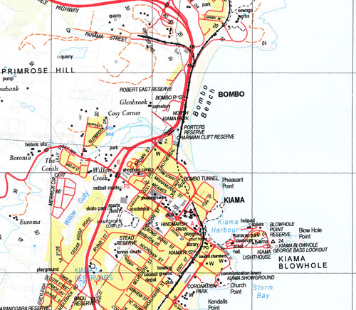
Kiama 1-25,000 NSW Topographic Map
$16.95 – $31.95
Description:
9028-1-S PRINT ON DEMAND
1-25,000 Scale NSW Topographical Map is used for Walking, 4WD, Fishing, Camping, Motorcycle, both On and Off Road, Gold Prospecting and for those simply going for a family weekend drive.
Topographical maps show not only Contours of the Terrain but also Walking Tracks, Sealed and Unsealed Roads, Rivers, Creeks, Lakes, Historical Point of Interest, Old Mine Sites and National and State Park areas.
 Laminate and folded this NSW Topographical map, $12.00 see below
Locations within this Map
Gerringong Jamberoo Kiama Bare Bluff Beachside Blow Hole Point Black Beach Bombo Bombo Beach Bombo Railway Station Bong Bong Creek Bong Bong Mountain Boona Range Boona Ridge Mount Brandon Buena Vista Carwa Creek Cathedral Rocks Church Point Colyers Creek Connors Creek Crooked River Curramore Currys Mountain Easts Beach Endeavour Lookout Fountaindale Creek Fountaindale Dam Foxground Geering Bay Gerringong Cemetery Gerringong Harbour Gerringong Post Office Gerringong Public School Gerringong Railway Station Hindmarsh Park Hyams Creek Irvine Oval Irwins Creek Jerrara Jerrara Creek Jerrara Creek Dam Kendalls Beach Kendalls Point Chapmans Point Geringong Geringong General Cemetery Geringong Harbour Gerring Bay Jerrera Jerrera Creek Jerrera Creek Dam Keith Irvine Oval Kiama Downs Kiama Harbour Kiama Heights Kiama High School Kiama Public School Kiama Lighthouse Kiama Railway Station Kiama Surf Beach Little Blowhole Little Blowhole Reserve Mcfauls Creek Mcilwrath Creek Marsden Reserve Minnamurra Point Minnamurra Railway Station Minnamurra River Minumurra Point Mount Pleasant Ridge Munna Munnora Creek Noorinan Mountain North Kiama Park Nuninuna Range Omega Flat Omega Railway Station Ooaree Creek Paddy Dalys Range Paddy Dalys Ridge Pheasant Point Pioneer Creek Mount Pleasant Porters Reserve Priests Beach Primrose Hill Rangoon Island Red Bluff Red Cliff Reid Park Robertson Basin Rose Valley Rose Valley Creek Rose Valley Gully Round Hill Saddleback Lookout Saddleback Mountain South Head Spring Creek Sproules Creek Stack Island Surf Beach Tangalla Creek Tangalla Gully Tates Range Tates Ridge Terragong Swamp The Blowhole Tootawallin Tootawallin Gully Turpentine Creek Wallaces Creek Wants Hill Werri Beach Werri Creek Werri Gully Werri Lagoon Werri Reserve Wesley Park Willow Creek Willow Gully Willow Vale Wyalla Falls Bumbo Birriebungie Reserve Blowhole Point Reserve Bonaira Reserve Boyds Beach Bungulla Reserve Coronation Park George Bass Lookout Jamberoo Park Jamberoo Public School Jones Beach Jubilee Park Kendalls Point Reserve Stan Miller Reserve Rangoon Reserve Storm Bay Noble Reserve Lloyd Rees Reserve Charmian Clift Reserve Karrawarra Reserve James Muir Miller Reserve Gerry Emery Reserve Stead Reserve Marsden Head Kaleula Head Broughton Village Robert East Reserve Boxsell Oval Bulga Reserve Badu Reserve Konda Reserve Waabie Reserve Frys Creek Minnamurra Minumurra River Colewood Burra Creek Linburn Foantaindale Creek Gowan Brae Hawthorn Culwalla The Pines Greyleigh Ben-Eden Strathlevan Mathervale Bushbank Bienheim Karrwara Brookfield Park View Hollymount Dunoon Bonnie Doon Ivymount Gerringong Station Omega Station Tomlins Hill Foxground Creek Broughton Vale Broughton Innisfail Homeleigh
| Name: | Kiama |
| Publisher: | New South Wales Government |
| Scale: | 1:25000 |
| Latitude Range: | 34° 37.5′ S – 34° 45.0′ S |
| Longitude Range: | 150° 45.0′ E – 151° 0.0′ E |
| Datum: | GDA 94 |
| Approx Print Size: | 0.56m X 1.11m |


