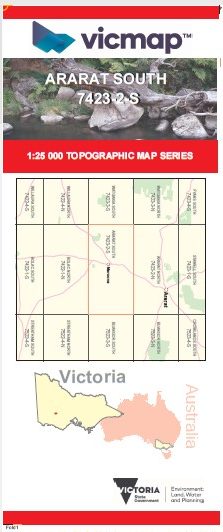

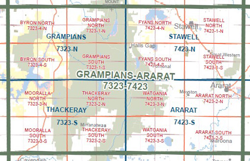
ARARAT SOUTH 1-25,000 Vicmap Topo Map 7423-2-S
Price range: $14.00 through $26.00
Description:
ARARAT SOUTH 1-25,000 Vicmap Topographic Map 74232S Now Print On Demand is used for Walking, 4WD, Fishing, Camping, Motorcycle, both On and Off Road, Gold Prospecting and for those simply going for a family weekend drive.
This is a new series of 1-25,000 scale maps, all sections of Victoria are now covered by these maps, including maps over the South Australian and NSW Borders.
Topographical maps show not only Contours of the Terrain but Walking Tracks, Sealed and Unsealed Roads, Rivers, Creeks, Lakes, Historical Points of Interest, Old Mine Sites mbtg and National and State Park areas.
Main Features of this map includes:
Willaura North, Kia Ora, Lake Buninjon, MOUNT MOORNAMBOOL, Rossbridge, Maroona, BURRUMBEEP HILL, Langi Logan, Tatyoon North
You may also like…
-
The Pyrenees Touring Map Meridian Edition 1
Price range: $15.95 through $26.95Select options This product has multiple variants. The options may be chosen on the product page -
ARARAT NORTH 1-25,000 Vicmap Topo Map 7423-2-N
Price range: $14.00 through $26.00Select options This product has multiple variants. The options may be chosen on the product page -
Ararat 1-50,000 scale Vicmap Topo Map 7423-S
Price range: $12.00 through $24.00Select options This product has multiple variants. The options may be chosen on the product page -
GRAMPIANS ARARAT 1-100,000 Vicmap 7323-7423
Price range: $14.00 through $26.00Select options This product has multiple variants. The options may be chosen on the product page