


Bogong Alpine Area Map ONLY Spatial Vision
$16.95 – $28.95
Description:
This is a Print on Demand Map single sided MAP ONLY no text

FOR THE 2 SIDED VERSION OF THIS MAP, SEE BELOW
Bogong Alpine Area Map Spatial Vision – Maps, Books & Travel Guides (mapsbookstravelguides.com.au)
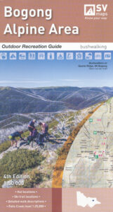
Bogong Alpine Area Map Outdoor Recreation Guides by Spatial Vision
SCALE: 1:50,000
COVERAGE: Bright, Harrietville, Mount Beauty, Falls Creek, Hotham Heights, Dinner Plain
IDEAL FOR: Bushwalking,skiing, mountain biking and car touring
EDITION: 4 th
SIZE (unfolded): 1,000mm wide and 810mm high
Information on other activities such as mountain biking, alpine skiing, horse riding, car touring, four-wheel-driving and fishing.
Campground and Lookout locations, and GPS references
Emergency marker locations, with index provided
1:25,000 map inset of Falls Creek and surrounds
Read More