Drysdale 1-250,000 Topographic Map
Price range: $15.95 through $30.95
Description:
Print on Demand
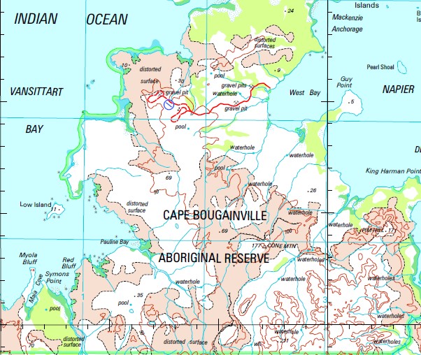
Kalumburu Andrew Creek Aragoon August Point Barton Plain Barton Plains Barton River Bedinbai Bertram Cove Beta Creek Bird Island Bluff Point Boomerang Yard Borda Island Bruce Creek Bulldust Yard Bundilee Cape Bernier Carlia Creek Carson River Cliffy Point Cole Creek Collison Range Cone Mountain Coondillah Creek Cracticus Falls Deep Bay Dominic Creek Doongan Drysdale River Drysdale River National Park Dulcis Falls Dysphania Gorge Eeryoo Encounter Cove Face Point Finches Creek Fish Rock Forest Creek Freshwater Bay Galaxy Swamp Glider Gorge Gonai Guy Point Henry Reef Hill Point Honeymoon Beach Community Ian Bay Jar Island Jiringgur Johnson Creek Jooroo Ridge Judjamoorie Pool July Point Jumburr Hill June Point Kalumburu Aerodrome Kalumburu Community Kalumburu Mission Kalumburu Remote Community School King Edward River King George Falls King Harman Point Langoor Hill Larriman Yard Larryoo Lauwa Creek Longini Loonjool Creek Lorroomoondanee Creek Louis Islands Low Island Lowya Creek Mackenzie Anchorage Maia Cove Majun Malinjar Mama Hill Mangarr Mcdonald Creek Meealoyoo Hill Merrinjie Middle Osborn Island Milyoonga Mission Bay Mission Cove Mission Rocks Moiyoo Creek Monger Creek Mongonai Creek Monorromboora Hill Mool Mool Lagoon Moondoalnee Moongool Gorge Moonlight Yard Moorello Morgan River Mount Connelly Mount Connor Mount Keating Mount Leeming Mount Reid Myola Bluff Napier Broome Bay Ngalawaree Ngoollalah Creek Noachitty Rapids Noolawayoo Creek North Rock Nymphaea Creek Oombrai Hill Ooraro Hill Orchid Creek Osborn Islands Oyster Rock Pago Palmoondoora Palmoondoora Creek Pangoor Pangoor Creek Parndia Creek Parry Harbour Pauline Bay Pearl Shoal Petrogale Gorge Petrophassa Creek Pim Hill Planigale Creek Ponai Creek Poompangala Hill Pronga-Marie Creek Putairta Hill Red Bluff Robin Gully Rocky Cove Rosendo Creek Schizaea Creek Seaflower Bay Seppelt Range September Point Sir Frederick Hills Solea Falls Swider Creek Symons Point Tate Point Theda Tidepole Hill Tilwillie Pool Tingun Creek Truscott Airbase Truscott-Mungalalu Aerodrome Ubach Creek Vansittart Bay Wade Creek Wallis Peak Waloobanbeningai Wanan Creek Waneenee Waratah Shoal West Bay Wollangooyoo Pool Wonjarring Woonjah Creek Woppinbie Creek Yinaringgai Creek Yoolo Creek Yoorawai Billabong Young Creek Louis Islets Pago Mission Drysdale River Mission Station Jar Islet North Island Oomari Longini Landing Oorara Hill Poomrangala Hill Caloombooroo Mission Osborne Islands Langoar Hill Pangoar Odmbrai Hill Dumburr Hill
| Name: | Drysdale |
| Publisher: | Geoscience Australia (Australian Government) |
| Scale: | 1:250000 |
| Latitude Range: | 14° 00.0′ S – 15° 00.0′ S |
| Longitude Range: | 126° 0.0′ E – 127° 30.0′ E |
| Projection / Datum: | Universal Transverse Mercator, GDA94 |
| Approx Print Size: | 0.44m X 0.67m |
| Publication Date: | 1-Jun-03 |