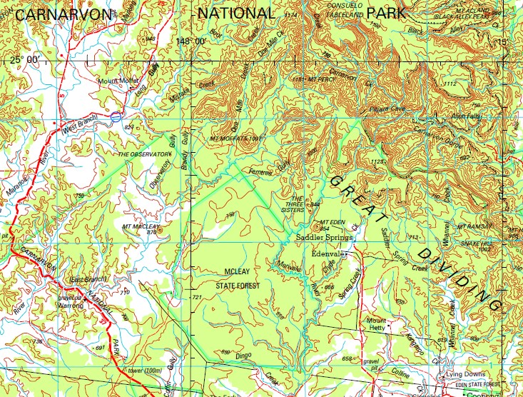
Eddystone 1-250,000 Topographic Map
$15.95 – $30.95
Description:
Print on Demand
Ingelara Mount Moffat Barngo Early Storms Bandana Torres Park Cunno Yanalah Mount Bullen Bullen Warrong Babbiloora Mount Hetty Mount Tabor Lying Downs Attica The Fork Glenolive Forfar Calline Creek Charlies Creek East Sunrise Yoothappinna Darkwater Sunrise Lorne Derbyshire Downs Tunis Mount Owen Hoganthulla Merivale Wetlands Redbank Oak Vale Hillside Rockvale Kildare Timor Silverleaf Crowman Womblebank Home Paddock Moorak Munnaweena Redford Tooloombilla Bungaringa Boxland Quida Downs Blue Hills Glenallen Bendoba Myall Woodlawn Iona Alligator Creek Apple Tree Creek Arch Creek Aubrey Back Creek Bally Lethbridge Battery Gully Bendee Mountain Bevan Spring Big Bend Gully Big Rocky Creek Billin Billin Creek Mount Black Blackfellow Creek Bobs Gully Bogarella Bothwick Box Creek Brandy Gully Bull Gully Bullock Creek Bullock Gully Bullock Mountain Bulmore Creek Bundara Bundara Creek Bungle Creek Mount Campbell Canterbury Spring Carnarvon Gorge Carpenter Gully Cave Creek Cedar Gully Channin Creek Charley Creek Chesterton Chesterton Creek Chesterton Range Christmas Creek Mount Clift Clyde Creek Coffin Gully Collins Creek Colquhour Gully Coopermurra Creek Copland Crystalbrook Cumalong Creek Cunno Creek Darkwater Creek Dingo Creek Dingo Gully Dooloogarah Creek Mount Drummond Dugarry Dundee Creek Eddystone Eddystone Gully Mount Eddystone Eden Mount Eden Eight Mile Gully Mount Elliot Faraday Creek Ferntree Gully Fig Tree Gully Five Mile Creek Fleming Creek Forest Vale Forest Vale Water Facility Forfar Water Facility Gap Gully German Gully Glenlinder Creek Gorge Gully Mount Grassy Green Gully Greenhills Waterhole Haley Creek Haystack Swamp Hebron Hobkins Lagoon Mount Hodgson Hoganthulla Water Facility Mount Hopeless Horse Creek Howe Mount Howe Howigin Waterhole Hutton Creek South Branch Mount Hutton Huttonvale Innisfallen Ironbark Gully Joe Creek Mount Judy Kangaroo Creek Karil Karil Water Facility Kelly Gully Mount Kennedy Kennel Creek Mount King Koolbellup Lagoon Gully Lambing Creek Lambing Gully Little Borer Creek Little Rocky Creek Lobs Gully Long Gully Mount Macleay Maranoa River East Branch Maranoa River West Branch Marlong Creek Maxvale Creek McDonald Creek McLeay Merivale River Mount Misery Mistake Creek Mount Moffatt Morella Morella Gully Mount Yanalah Munga Murphy Creek Murphy Tableland Muya Creek Myall Gully Nine Mile Gully O’Brien Causeway Oak Downs Oakleigh Oaky Creek Observatory Gully Ogilby Ogilby Gully Ogilby Knob Mount Ogilby One Mile Creek Owen Gully Mount Percy Mount Playfair Policeman Gully Possession Creek Possession Creek Water Facility Prior Punchbowl Gully Rams Gully Mount Ramsay Redford Creek Redford Water Facility Reedy Creek Road Gully Rockvale Creek Rocky Creek Rough Mountain Round Swamp Mount Round Saddler Spring Creek Sams Creek Sandy Creek Sawpit Creek Seven Mile Creek Sheep Station Gully Sidesaddle Gully Silverleaf Creek Silverleaf Water Facility Simpson Simpson Creek Six Mile Creek Sleepy Creek Smith Creek Snake Hill Southlands Spa Spring Spring Creek Spring Gully Springbok Springvale Creek Springvale Spring Mount Springvale Station Creek Sunnyside Tabor The Crater The Observatory The Three Sisters Three Mile Creek Tickencote Tickerabang Creek Tipperary Creek Tom Toms Corner Torres Creek Trace Chain Creek Trident Creek Troopers Gully Twelve Mile Creek Twenty Mile Creek Two Mile Creek Wards Canyon Warrong Water Facility Washpool Creek Western Creek Westerton Westgrove Whannel Whannel Creek White Flat Creek Whitfield Whitfield Water Facility Woolshed Creek Yanalah Creek Yard Creek Upper Warrego Forestvale Hutton Creek Redford Roma Regional Council Great Dividing Range Eastern Highlands The Great Divide Cumalong Well Ralph Creek Aljon Falls Bandanna Mount McLeay Tysons Well Mount P.P. King Eden Vale Warrong Hut Carnarvon Range Cunno Well Carella Mount Cliff West Branch Maranoa River Western Branch East Branch Maranoa River Mount Ogilvie Trident Dam Ogilvie Knob Ogilvie Hobkirks Lagoon Mount Brandon Bore Ogilvie Creek Two Mile Dam Springvale Gas Field Myrtleville Bore Twenty Mile Dam Myrtleville West Fifteen Mile Dam Myrtleville Whannell Creek Big Springs Mountain Gully Dam Yellowbank Gas Field Webbs Tank Mountain Gully Bore MacDonald Creek Borer Creek Westgrove Gas Field Pine Camp Bore Merivale Gas Field Yellow Cliffs Back Creek Bore The Farm Killarney Hoganthulla Bore Muya Tank Oak Downs Bore Doyle Gully Colquhoun Gully Battery Tank Taylors Plains South Branch Hutton Creek Warrenville Bullin Creek Four Mile Tank Two Mile Tank Gracemere Bore Purfleet Boxland Bore White Tank Mourak Glentulloch Gas Field Muldoon Dam Silverleaf Bore McCawley Tank Bluff Bore Booka Butha Maxvale Bore Bassett Bore Redford Bore Maxvale Out Station Six Mile Bore Rocky Bore Elray Forestva Ouinda Downs Woolshed Bore Southlands Bore Emmavill Mount Elliott Copthorne Black Stump Dam Mitchell Bore Forest Vale Bore Mirani
| Name: | Eddystone |
| Publisher: | Geoscience Australia (Australian Government) |
| Scale: | 1:250000 |
| Latitude Range: | 25° 0.0′ S – 26° 0.0′ S |
| Longitude Range: | 147° 0.0′ E – 148° 30.0′ E |
| Projection / Datum: | Universal Transverse Mercator, GDA94 |
| Approx Print Size: | 0.44m X 0.67m |
| Publication Date: | 1-Jun-03 |


