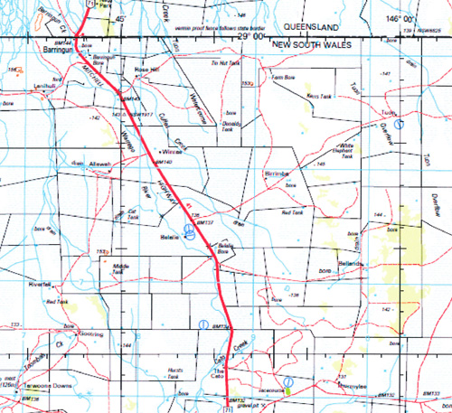
Enngonia 1-250,000 Topographic Map Topographic Map
$15.95 – $30.95
Description:
Locations within this Map
Randwick Downs Toulby Rose Hill Nala Rostella Lanihuli Tuon Widgee Downs Sharoon Winrae Morton Plains Brooksville Waggan Allawah Eureka Plains Birrimba Kahmoo Burban Grange Karalee Ellerslie Waratah Glenora Belalie Dunsandle Kulkyne Bellands Riverfall Gerara Glenmore Bourkes Tank Orana Burbar Wirrawarra Milanda Oswald Goolring Fairfield Glenalbyn Weilmoringle Wapweelah The Cato Bullabelalie Tarwoona Downs Thurmylae Whyman Noorooma Narrawandi Myuna Bukulla Wandella Woolahra Caringle Beulah Urie Point Baringa Lochnagar Wilganea Maylands Boolaboo Congararra Nulty Springs Cartlands Multagoona Bora Boneda Taralba Springvale Dalwood Paisley Lissington Stanbert Staffa Culgoa Downs Talawanta Grass Hut Lila Springs Innisfail Salvation Linchden Inverness Yarkeita Eurah Bellenbar Mundiwa Milroy Bellfields Corella Corella East Tuncoona Bullaroon Harriet Park Lower Lila Calooma Wongal Tara Bokhara Plains Garlands Moongulla Warrella Plains Bundy Westmunda Twin Rivers Allambie Birralee Coolabri Glandore Wongalea Meadow Plains Kenebree Gumbooka Glengeera Mitchell Vale Prairie Gumbercoo Gurrawarra Bundeera Lauradale Kanimbla Lilyfield Coola Marion Downs Belvedere Artesia Wirracanna Quantambone Goonoo The Lagoon Warraweena Goonoo Goonoo The Rocks Pine-View Turee Beemery Bunnawanna Wolkara Gundawera Mapoga Yambacoona Bulola Walkdens Llandillo Bethcar Cooley Arbour Merriman Brewarrina Enngonia Anabranch of Irrara Creek Barringun Barringun Astronomical Station Barringun Bore Barringun Creek Beemery Point Belalie Bore Bibildoolie Bickerjerry Creek The Big Island Birdsnest Swamp Boomery Dam Bottom Lila Lake Bough Bourrawarana Creek Bow Creek Brewarrina Aerodrome Brewarrina Central School Brewarrina Common Brewarrina Railway Station Brewarrina Weir Brigalow Bore Briglow Bore Brumby Waterhole Bubbermore Creek Carrs Waterhole Cato Creek Collerina Coolabah Creek Cuffes Creek Darling River Eighteen Mile Tank Enngonia Bore Gidgea Camp Bore Gilgai Waterhole Gooroomero Spring Grass Hut Tank Grogans Waterhole Gunderbooka Hailstone Tank Mount Hope Horseshoe Lagoon Hospital Creek Irrara Anabranch Irrara Creek Jobs Gate Johns Creek Kellys Camp Bore Kellys Waterhole Gidgee Camp Bore Grogans Hole Gurrera Spring Hospital Creek Part Only The Lake Tank Ledknappa Tank Ledknappa Ledknapper Creek Ledknapper Tank Leila Lila Little Bogan River The Little Bogan Little Culgoa Creek Lower Lila Dam Marion Creek Marion Flats Milroy Tank Minbera Plain Model Hut Lake Mulga Multagoona Dam Multagoona Lagoon Mungulah Creek Munguryania Waterhole Multagoona Creek Narrandool Creek Native Dog Bore Nebine Creek Nimbera Plain Nineteen Mile Tank Nooramia Creek Noorooma Creek Old Geraba Springs Overshot Dam Piano Creek Pickerjerry Creek Pirillie Dam Quartpot Sandhill Racecourse Swamp Red Gate Tank Ropers Creek Ropers Gully Seventeen Mile Plain Sibraas Bore Six Mile Dam Stony Point Sutherlands Lake Ten Mile Waterhole Toms Lake Tooloomai Spring Tooloomi Spring Toomba Toombah Creek Top Brigalow Lagoon Toulby Gate Toulby Gate Bore Tuen Creek Tulls Bore Tuon Overflow Tuon Overflow or Watercourse The Tuon Watercourse Tuon Watercourse The Tuon Creek Upper Darling River Walkdens Bore Walkdens Plain Warraweena Lagoon Weilmoringle Public School Weir 15 Whiskey Creek Whitewood Bore Widgeegoara Creek Willara Creek Willveroo Creek Wongal Cowal Wyaman Waterhole Yambacoona Cowal Yambacuna Cowal Yambacuna Lagoon Diemunga Lagoon Diamantina Dam Druid The Dry Lake Dry Bogan Bunnavinyah Spring Burban Creek Burbar Creek Burnes Burns Creek Kullyna Sandy Springs Gunderwerrie Anderson Booroominia Brolga Bundaleear Buntawarrara Cedia Cockellireena Coolibar Coward Diemunga Dingo Emu Hill Grindie Gurrera Hardie Jamieson Keats Loxton Malgoolie Milroy West Mudelooromun Opal Power Tatala Tawaggan Thurlagoona Wee Warra Weejallah Yamby Yarran Bourinawarrina Brandis Coolamon Cooning Cooper Courallie Cumbooka Cuttabulla Darling Galar Goldson Greig Ledknapper Looden Mooramia Mungunyah Nellys Springs Nidgerie Palmer Polo Quondong Sutherland Tresillian Wommera Yarraman Yurongan Conroy Dwight Gibson Bannockburn Blantyre Boonderra Bragla Bruce Bunyip Cato Drumdelang Gannawarra Gidgier Jumbuck Kelvedon Konowogan Lignum Linchiden Mohenia Nardoo Narrandool Papperton Waroma Wilga Wureep Yarkieta Zara Tully Moco Barungha Yambacuna Currindule Payera Yamby West Boomery Scott Cranbrook Ledknapper Nature Reserve North Bourke Cuttaburra Creek Flats of Widgeegoara Creek Kungie Warrego River Wooroorooka Nebie Creek Wapwella Cartland Old Corella Native Dog Artesian Bore Brigalow Cockellineena Birrie River Collerina Weir Lake Tank Hospital Creek Tank Fords Bridge Tank Belvidere Bokharra River Bokhara River Weir Fifteen Bogan River Culgoa River Mount Druid Yambacuma Darling Shire
Part of the Darling River
| Name: | Enngonia |
| Publisher: | Geoscience Australia (Australian Government) |
| Scale: | 1:250000 |
| Latitude Range: | 29° 0.0′ S – 30° 0.0′ S |
| Longitude Range: | 145° 30.0′ E – 147° 0.0′ E |
| Projection / Datum: | Universal Transverse Mercator, GDA94 |
| Approx Print Size: | 0.44m X 0.67m |


