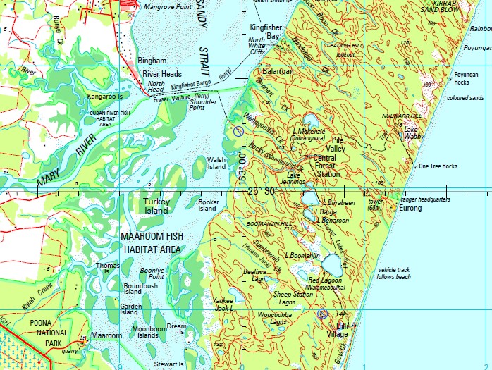
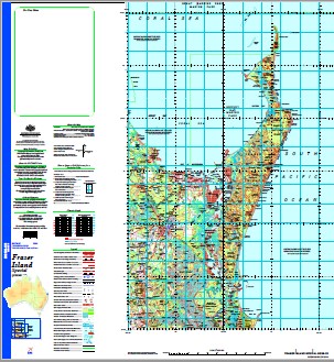
Fraser Island Special 1-250,000 Topographic Map
$15.95 – $30.95
Description:
Print on Demand
Toogoom Stony Creek Tandora Mariana Logwood Kiaora Delamere Gutchy Dun Bobbin Dilkusha Fairview Stewart Hill Rosedale Red Hill Netherton Glenelg Emohruo Ulirrah Bungawatta Allendale Millbrook Booral Burrum Heads Cooloola Cove Craignish Dundowran Dundowran Beach Hervey Bay Howard Maryborough Rainbow Beach River Heads Tiaro Tin Can Bay Torbanlea Woodgate Beach Maaroom Orchid Beach Bauple Eurong Boonooroo Tuan Tinnanbar Poona Point Gunalda Akuna Creek Alderney Island Aldershot Aldridge Creek Alligator Creek Allom Lake Arch Cliff Atkinsons Mountain Aubinville Awinya Creek Baddow Baddow Island Balarrgan Bare Hill Lake Barga Basin Lake Bauple Creek Bauple State Forest Mount Bauple Beaver Rock Beelbi Creek Beeliwa Lagoon Beemeer Benarige Creek Lake Benaroon Bennet Creek Bennetts Waterhole Biddierr Creek Bidwill Bidwill Creek Big Angle Big Boar Creek Big Sandy Creek Big Tuan Creek Big Woody Island Bimjella Hill Bingham Binngih Lake Birrabeen Birre Black Creek Black Lagoon Black Rock Black Spring Black Swamp Creek Black Swan Creek Blackfellow Point Blackmount Blowah Lakes Blowah Rocks Boar Creek Bogimbah Creek Bongmollow Bookar Island Boomanjin Airstrip Boomanjin Hill Lake Boomanjin Boomerang Lakes Boon Boon Creek Boonlye Point Boonooroo Point Boonoy Creek Boowon Boronia Bowal Creek Bowarrady Bowarrady Creek Lake Bowarrady Breaksea Spit Bridge Creek Brothers Islands Browns Camp Browns Camp Creek Browns Rocks Bunya Creek Burgowan Burrgum Hill Burrum Burrum Point Burrum River Burrum Coast National Park Burrumba Butchers Creek Buttenshaw Bank Buttha Creek Calarga Lagoon Cameron Creek Cameron Point Carland Creek Carlo Carlo Creek Carlo Island Carlo Point Carree Central Forest Station Chard Rocks Cherwell River Chinaman Creek Ching Island Colton Cooloola Cooloola Coast Cooloola Creek Coolooloi Creek Coomboo Lakes Coonangoor Creek Coondagarramine Creek Coondoo Creek Coongul Creek Coongul Point Coonoagarramine Creek Coonoongwa Waterholes Coorong Creek Copenhagen Bend Cornwell Gully Corroboree Beach Cowra Cowra Point Crab Islands Crab Point Crooked Creek Cubbih Creek Culvert Creek Datum Point Datum Rock Dayman Dayman Point Dayman Spit Deepwater Lake Denison Devils Elbow Dickabram Dimond Creek Dinna Creek Dinnies Creek Dipuying Dixons Creek Doolong Flat Doongul Creek Double Island Point Dream Island Duck Creek Duck Island Duckinwilla Creek Dundathu Reach Dundonga Creek Dundubara Creek Dunmora Dutton Creek Mount Eaton Eight Mile Rocks Eighteen Mile Creek Elbow Point Eli Creek Eli Point Elliott Enchanted Valley Eudlo Point Fairfield Ferguson Ferguson Spit Figtree Creek Figtree Lake Fison Point Flinders Fork Bank Fraser Island Freshwater Lake Freshwater Lakes Gables Point Lake Garawongera Garden Island Lake Garry Gatakers Bay Lake Geeoong Geewan Creek German Creek Gerowweea Creek Girkum Creek Glenwood Lake Gnarann Goochee Lagoon Gootchie Govi Creek Grahams Creek Granville Grassy Mountain Great Sandy Strait Gregory Islands Gregory River Griffen Creek Guernsey Island Gunalda Gap Gunchellan Swamp Gundiah Gutchy Creek Guyra Mountain Happy Valley Happy Valley Creek Harwood Creek Heath Island Heath Reach Hercules Hidden Lake Hook Point Horseshoe Bank House Creek Ida Island Indian Head Inner South Head Inskip Point Isis River Jabiru Swamp Jacobsons Hill Yankee Jack Creek Jeffery Rock Lake Jennings Jersey Island Johnny Point Johnnys Creek Johnsons Crossing Jordan Creek Judd Point Jumpo Creek Kalah Creek Kangaroo Creek Kangaroo Island Kanigan Creek Mount Kanigan Kanyan Kauri Creek King Parrot Creek Kirrar Kooringa Koorooman Kunst Crossing Kurrnung Creek Lagoon Creek Lake Charles Leading Hill Leg Bank Leslie Reach Little Boar Creek Little Duck Island Little Rocky Creek Little Tahiti Creek Little Tinana Creek Little Tuan Creek Little Woody Island Logbridge Creek Logging Creek Long Shoal Lorne Bank Maaroom Creek Maheno Beach Manann Beach Mangrove Island Mangrove Islands Mangrove Point Manoolcoong Lakes March Maria Creek Markwells Spur Marloo Bay Marong Ridge Lake Marong Marsh Creek Mary River Maryborough West McGregor Creek Lake McKenzie Meereenyoor Creek Meteor Point Middle Bank Middle Bluff Middle Rocks Lake Minker Minni Minni Creek Mooan Moolyyir Creek Moon Point Moonbi Moonboom Islands Moondoora Lagoon Mosquito Creek Mount Eaton Creek Mullen Creek Mungar Myrtle Creek Nashs Gully Native Dog Creek Ndtooching Neerdie Tiaro Shire Neerdie Mount Neerdie Netherby New Island Newtown Ngarr Lagoon Nikenbah North Bluff North Channel North Cooloola Point North Head North Ngkala Rocks North Shore Point North Spit North White Cliffs Nulla Kunggur Nulwarr Hill O’Regan Creek Oaky Creek Ocean Lake One Tree Rocks Opossum Creek Orange Creek Outer Banks Owanyilla Oyster Bank Oyster Rocks Pallas Street Panama Creek Pannikin Island Paterson Pearl Bank Penny Mountain Phoenix Waterholes Picnic Island Pilbil Waterhole Pilerwa Pine Valley Platypus Bay Point Vernon Poona Poona Creek Poona Lake Porpoise Shoal Poverty Point Powell Creek Power Island Poyungan Poyungan Creek Poyungan Rocks Poyungan Valley Proctor Creek Pulgul Creek Puthoo Creek Rainbow Gorge Ration Creek Red Lagoon Red Ridge Creek Redbank Creek Reindeer Rock Richmond Creek Rocky Creek Rocky Point Rooney Point Round Bush Island Round Island Running Creek Salt Creek Saltwater Creek Sandfly Creek Sandy Cape Sandy Cape Shoal Sandy Creek Sandy Point Sandy Point Bank Sark Island Sawpit Creek Scott Rock Scrub Turkey Creek Scrubber Creek Scrubby Creek Searys Creek Semaphore Creek Separation Point Seventy Five Mile Beach Shark Inlet Sheep Station Lagoons Sheepbreak Creek Shell Bank Shelly Bank Sheridan Island Ship Channel Shoulder Point Sinfields Hill Six Mile Creek Slain Island Slaty Creek Slogertys Creek Smooger Point Snapper Creek Snapper Point Snout Point South Bank South Channel South Cooloola Point South Head South Ngkala Rocks South Point South Spit South White Cliffs O’Regan Creek Conservation Park Pipeclay National Park Spudo Gully St Helens Maryborough City St Mary Station Hill Stewart Island Stewarts Camp Creek Stockyard Creek Sugarbag Creek Sugarloaf Creek Susan Island Susan Point Susan River Tahiti Tahiti Creek Takura Heights Talboor Taleerba Creek Talegalla Weir Tawan Tea-Tree Creek Teahwan Teahwan Rocks Teddington Weir Teebar Creek Teebean Point Teewah Creek Teewah Point Tenimby Creek Tewan Creek Thangawang Creek The Bar The Bluff The Cathedrals The Pines The Pinnacles The Red Bank The Reedy Water Hole Theebine Theebine Mountain Theodolite Creek Thomas Island Thow-Wool Lagoon Tin Can Inlet Tinana Tinana Maryborough City Tinana Ford Tinana Creek Tinana Island Tooan Tooan Creek Toogoom Waterhole Toolara Tooleenba Creek Tooloora Creek Tootawwah Creek Tooth Island Toowoora Creek Towoi Creek Towoi Swamp Triangle Cliff Tukkee Turkey Creek Turkey Island Tyroom Roads Ulirrah Creek Ululah Creek Ungowa Creek Upper Mouth Susan River Upper Rocky Point Urang Creek Urangan Urow-Wa Lakes Vernon Violet Creek Lake Wabby Waddy Waddy Point Walker Reach Walkers Point Walliebum Walliebum Lagoon Walliebum Waterhole Walsh Walsh Island Wang-Ann Lagoon Wanggoolba Creek Lake Wanhar Warren Creek Wathumba Wathumba Creek Wathumba Swamp Watson Creek Lake White Wide Bay Wide Bay Harbour Wobber Creek Wobber Springs Wocco Lagoon Wolf Rock Woocoonba Lagoons Woolaan Woolmer Creek Lake Woonjeel Woralie Creek Wyuna Creek Yankee Jack Lake Yard Creek Yathon Cliffs Lake Yeenan Yeenyargoor Creek Yeerall Creek Yengarie Yerra Yidney Creek Yidney Lake Yindeering Lakes Young County of March Lake Lenthall Cockburn Gutter Timbrell Creek Antigua Boolla Lagoons Wokka Baddow Island Conservation Park Beelbi Creek Conservation Park Duggan Conservation Park Granville Conservation Park Great Sandy Conservation Park Kauri Creek Conservation Park Mount Bauple National Park Scientific Police Paddock Conservation Park Poona National Park Tinana Creek Conservation Park Tinana Island Conservation Park Vernon Conservation Park August Creek Cypress Creek Deep Creek Pile Valley The Declivity Tarwhine Point Mariana Creek Gobbles Gully Bauple Forest Kanigan Mungar Tiaro Shire Owanyilla Tiaro Shire Pilerwa Tiaro Shire Pioneers Rest Teddington Tiaro Shire Toolara Forest Tiaro Shire Tuan Forest Tiaro Shire Yerra Tiaro Shire Aldershot Maryborough City Boonooroo Plains Fraser Island Maryborough City Great Sandy Strait Maryborough City Island Plantation Oakhurst Maryborough City The Dimonds Tuan Forest Maryborough City Ferney Glenorchy Mungar Woocoo Shire Owanyilla Woocoo Shire Pilerwa Woocoo Shire Teddington Woocoo Shire Tinana Woocoo Shire Tinana South Yerra Woocoo Shire Aldershot Hervey Bay City Burrum Town Duckinwilla Dundathu Eli Waters Fraser Island Hervey Bay City Great Sandy Strait Hervey Bay City Kawungan Pacific Haven Pialba Prawle Scarness Sunshine Acres Takura Torquay Urraween Walligan Wondunna Fraser Double Island Point Conservation Park Sandy Cape Conservation Park Great Sandy Strait Cooloola Shire Inskip Tin Can Bay Cooloola Shire Tuan State Forest Tin Can Bay Tiaro Shire Magnolia Wallu Neerdie Cooloola Shire Great Sandy National Park Wongi Forest Reserve Oakhurst Woocoo Shire Woodgate Arthur Creek Woakoh Lake Carrea North Gardner Bank Minker Orchid Beach Island Village North Triangle Cliff Triangle Cliffs Arch Cliffs Lake Bowarrdy Traviston Buxton Cherwell Creek Strathdee Creek Strathdees Creek Vernon Point Great Sandy Island ORegan Creek Boomerang Hill ORegan Creek Conservation Park Round Islet Woody Island Long Middle Bank Bogumbah Creek Tree Creek Scrub Hill Ghost Hill Mangrove Creek Duck Islands Little Creek Tyroom Road Shell Island Ketch Spit Seventy-Five Mile Beach Oakhurst Tumbowah Creek Dumbua Creek Lake Boemingen Tinana River Bounlyo Point Walameboulha Lagoon Moonboom Island Mungar Junction Boonaroo Point Huon Mundy Creek Kuari Creek Mount Bauple National Park Tin Can Creek Kanighan Cherry Venture Mount Kanighan Mount Kannagan Toolara Forest Wide Creek Wide Bay Creek Store Creek
| Name: | Fraser Island Special |
| Publisher: | Geoscience Australia (Australian Government) |
| Scale: | 1:250000 |
| Latitude Range: | 24° 30.0′ S – 26° 0.0′ S |
| Longitude Range: | 152° 30.0′ E – 153° 30.0′ E |
| Projection / Datum: | Universal Transverse Mercator, GDA94 |
| Approx Print Size: | 0.67m X 0.44m |
| Publication Date: | 1-Jun-05 |


