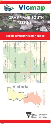
GRAMPIANS SOUTH 1-25,000 Vicmap Topo Map 7323-1-S
$14.00 – $26.00
Description:
THIS MAP IS IN THE NORTHERN SECTIONS OF THE GRAMPIANS, THE TITLE IS MISLEADING
Grampians South 1-25,000 scale Vicmap Topographical map 73231S NOW PRINT ON DEMAND is used for Walking, 4WD, Fishing, Camping, Motorcycle, both On and Off Road, Gold Prospecting and for those simply going for a family weekend drive.
This is a new series of 1-25,000 scale maps, all sections of Victoria are covered by these maps.
Topographical maps show not only Contours of the Terrain but Walking Tracks, Sealed and Unsealed Roads, Rivers, Creeks, Lakes, Historical Points of Interest, Old Mine Sites and National and State Park areas.
Main Features of this map includes:
Covers the old series Victoria Gap 1-25,000 and Moora Moora which is out of print
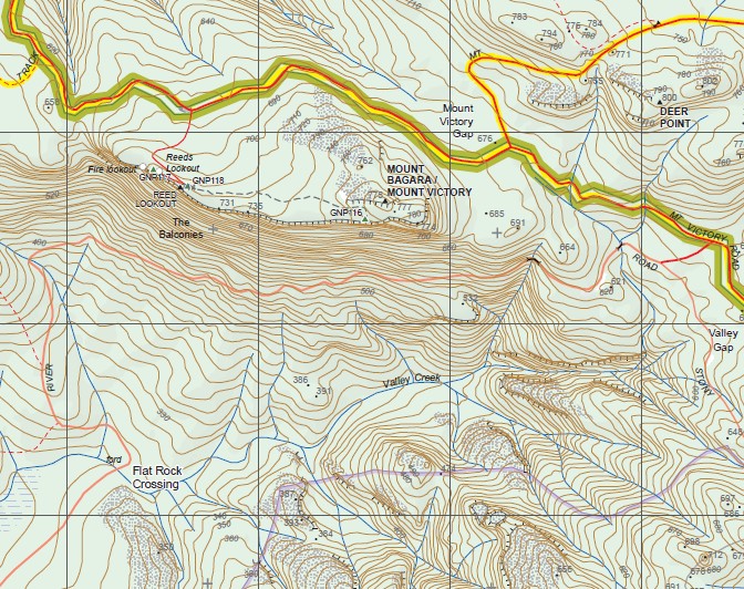
Victoria Range Remote and Natural Area, Yananginj Njawi Gap (Victoria Gap), Moora Moora, Moora Moora Reservoir, Glenisla Crossing, Glenisla State Forest, CAMP OF THE EMU FOOT SHELTER, Billywing State Forest, Jardwadjali Falls, Billimina Shelter, Buandik Campground, Cultivation Creek, BILLIMINA ROCK, Ti Tree Flat, MOOMGALG ROCKS /WALLABY ROCKS, Sheet Of Water Creek, Forest Lodge Forestry Camp, VICTORIA VALLEY (AIRFIELD), Moora Valley Reference Area (no public access), Glenelg River Road Bush Camp 1, Glenelg River Road Bush Camp 2, Moora Henham Bush Camp, Moora Moora Outlet Bush Camp 1, Moora Moora Outlet Bush Camp 2, Phillip Island mbtg,Track Bush Camp, Burrong Falls, Paddy Castle, BURRONG SHORT CUT TRACK, The Balconies, mbtg, Flat Rock Crossing, Boreang Campground, Mount Rosea Creek, Henham Track, Serra Range Remote and Natural Area, Calectasia Falls, Western Wall, Bundaleer Bush Camping, E P A C R I S H I L L S, Valley Gap, Deer Point, MOUNT BAGARA / MOUNT VICTORY, MOUNT VICTORY Gap, MOUNT NGUMADJ / MOUNT MCIVER, Epacris Falls, Wonderland Carpark, Stoney Falls, Pansy Falls, Turret Falls, Garden Of The Grampians, Rosea Track, Stony Creek Bush Camp 1 and 2, GRAND STAIRWAY, GATE OF THE EAST WIND, Sanderson Gap, Dalton Peaks, Middleton Gap, GURDGARAGWURD PEAK / DALTON PEAK,
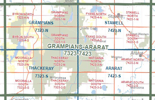
Only Part of the Grampians, please look at the Index Image
You may also like…
-
Grampians 1-50,000 Vicmap
$12.00 – $24.00Select options This product has multiple variants. The options may be chosen on the product page -
Thackeray 1-50,000 Vicmap
$12.00 – $24.00Select options This product has multiple variants. The options may be chosen on the product page -
The Grampians Special 1-100,000 Topo Vicmap
$12.00 – $24.00Select options This product has multiple variants. The options may be chosen on the product page