
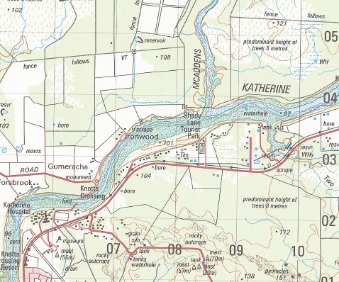

Katherine 1-50,000 Topographic Map 5369-2 NT
Price range: $14.95 through $26.95
Description:
Katherine 1-50.000 Topographic Map 5369-2 NT Print on Demand
Katherine Katherine Gorge Baruwei Loop Walk Biddlecombe Cascade Bullock Creek Butterfly Gorge Walk Callistemon Park Carpentaria Mining Area Casuarina Park Casuarina Street Pre School Casuarina Street Primary School Clyde Fenton Pre School Clyde Fenton Primary School CSIRO Farm CSIRO Research Station Dakota Park De Julia Park Donkey Camp Pool Donkey Camp Weir Dorothy Creek Drome Hill Dunlop Swamp Emungalun Eugene Betti Bridge Jatbula Trail Jodetluk Jukes Park Katherine Airfield Katherine Ambulance Station Katherine Cemetery Katherine Country Club Katherine Court House Katherine East Katherine Fire Station Katherine Gorge Ranger Station Katherine Government Centre Katherine High School Katherine Historical Museum Katherine Hospital Katherine Low Level Nature Park Katherine Police Station Katherine Post Office Katherine School Of The Air Katherine South Katherine South Pre School Katherine South Primary School Kintore Street Pre School Kintore Street School Knotts Crossing Knuckey Creek Kumdidgee Lansdowne Leight Creek Lily Ponds Walk MacFarlane Primary School Maluka Park Maud Creek Maud Creek Mining Area Maude Creek Mc Addens Creek Miali Brumby Miriam Springs Mount Shepherd Old Katherine Railway Station Pats Lookout Peckham Hill Roney Park Rosie Spring Rundle Park Ryan Park Smitt Rock Smitt Rock Walk Southern Rockhole St Josephs Primary School Two Mile Creek Uralla Warlpiri Transient Camp Windolf Walk Seventeen Mile Creek
| Name: | Katherine |
| Publisher: | Geoscience Australia (Australian Government) |
| Scale: | 1:50,000 |
| Latitude Range: | 14° 15.0′ S – 14° 30.0′ S |
| Longitude Range: | 132° 15.0′ E – 132° 30.0′ E |
| Projection / Datum: | Universal Transverse Mercator, GDA94 or WGS84 |
| Approx Print Size: | 0.56m X 0.56m |
| Publication Date: | 1-Jun-05 |
You may also like…
-
Comoye 1-50,000 Topographic Map 5469-3 NT
Price range: $14.95 through $29.95Select options This product has multiple variants. The options may be chosen on the product page -
Eva Valley 1-50,000 Topographic Map 5469-2 NT
Price range: $14.95 through $26.95Select options This product has multiple variants. The options may be chosen on the product page