
South Eastern Queensland Map 431 UBD Gregorys
$12.95
1 in stock
Description:
South Eastern Queensland Map 431 Edition 8 UBD Gregorys
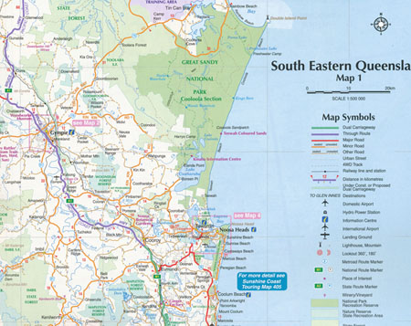
The latest edition of the South Eastern Queensland map has been fully revised and updated and includes regional coverage from Murgon, Gympie and Double Island Point in the north, Tenterfield and Evans Head (NSW) in the south, Columboola in the west and east along the coast from Double Island Point to Evans Head.
There is also an index to towns included on this coverage. There is also a smaller regional map at a scale of 1: 2 600 000 indicating the location of the towns and covering from Brovinia in the north, Deepwater (NSW) in the south and east along the coast from Rainbow Beach in the north to Bundjalung National Park (NSW) in the south & west to Glenmorgan.
Also included are street level maps at a scale at 1 : 20 000 for: the Gympie area including Araluen and Southside; Maroochydore and the surrounding suburbs including Buderim and Alexandra Headland; the Noosa area including the suburbs of Tewantin and Sunrise Beach.
There is also a street level map of Surfers Paradise from Main Beach in the north to Broadbeach in the south (at a scale of 1: 15 000), plus a map of Toowoomba town centre at a scale of 1 : 10 000.
This conveniently sized map is packed with information and is an essential tool when travelling around South Eastern Queensland.
Format: Sheet map, folded
Dimensions: 92cm x 69cm
Published 01 July 2022
ISBN 9780731932924