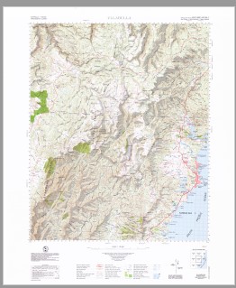
Ulladulla 1-100,000 Topographic Map Geoscience Australia
Price range: $14.95 through $29.95
Description:
Print on Demand
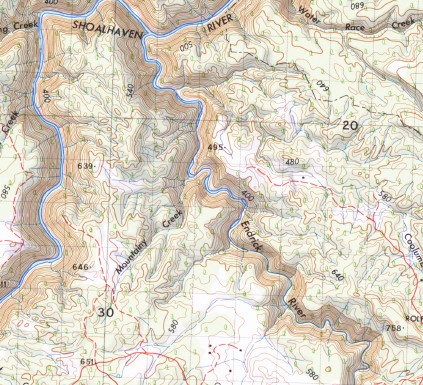
Burrill Lake Fishermans Paradise Kings Point Lake Conjola Lake Conjola West Lake Tabourie Milton Ulladulla Angels Falls Alum Creek Armours Creek Ashville Public School Angel Creek Admiration Point Adder Bay Backhouse Creek Back Range Creek Bainbrig Creek Bald Hill Baldy Bangalow Bay Bannisters Point Barneys Hill Battleship Rock Bawley Point Belowra Creek Bendalong Bendi Brook Berrara Creek Berry Head Bhundoo Hill Mount Bibbenluke Bibbenluke Walls Billys Hill Blands Creek Blacket Creek Black Bobs Creek Binnari Pass Bindi Brook Boodabah Creek Boolijah Boolijah Creek Boonbal Creek Boondobah Creek Boongan Mountain Booran Creek Boyne Boyne Creek Brandaree Creek Breakfast Creek Broad Creek Broad Gully Brooman Broula Brook Buckleys Beach Buckleys Point Mount Budawang Budawang National Park Budawang Range Bulee Bulee Brook Bulee Forest Bulee Gap Bulee Lookout Bulee River Yatteyattah Cambage Head Camping Rock Creek Camping Rock Ravine Camp Rock Canowie Brook Cardies Point Carisbrook Creek castle Creek Castle Gap Castle Head Castle Hill The Castle Cherry Tree Gully Claydons Creek Clyde Gorge Clyde River Clyde State Forest Cockpit Swamp Mount Cole Coles Creek Colley Spur Conjola Conjola Cemetery Conjola Creek Conjola Island Conjola Lake Conjola State Forest Cons Gap Coolumburra Coolumburra Creek Cooyoyo Creek Corang Corang Arch Corang Creek Corang Peak Corang River Coryala Creek Cradle Swamp Crafts Crown Crampton Island Croobyar Croobyar Creek Croobyar State Forest Crooked Creek Crooked Falls Cudmirrah Cundenarrah Bay Currock Currockbilly Currockbilly Mountain Currowar Creek Dark Brothers Cave Darri Head Darri Pass Davison Head Deep Creek Dendrobium Creek Endrick Endrick River Endrick State Forest English Ettrema Gorge Ettrema Ridge Fagans Point Falls Creek First Curradux Creek Flat Rock Flat Rock Creek Flat Rock State Forest Florance Head Flying Fox Gully Folly Point Folly Point Lookout Forks Basin Fosters Mountain Four Mile Creek Freeman Creek Gadara Point Galbraith Plateau Gallaghars Creek Gap Creek Garrets Hut Gully Georges Yard Gilberts Gap Glennelly Creek Gnatilia Creek Goodsell Basin Goodsell Creek Gooloo Creek Granite Falls Grassy Creek The Gulf Hancocks Creek Harper Head Mount Haughton Hawks Nest Gully Hidden Valley Hill Top Hoddle Creek Mount Hoddle Hoddles Castle Hill Hollands Creek Hollands Gorge Hollands Gully Hollands Point Horse Point Hume Head Hylands Lookout Ingold Gap Ingolds Knob Lookout Ironbark Bay Jerralong Jerrawangala Jerrawangala Lookout Jerrawangala State Forest Jerrawangala Valley Jerricknorra Jerricknorra Creek Jindelara Creek The Jumps Kalianna Ridge Kangaroo Hill Campus Head Careless Point Castle Flat Castle Point Cherry Tree Creek Clyde Canyon Colombaco Creek Crevasse Canyon Crooked Gully Cunjurong Lake Demon Scrub Denrobium Creek Dermal Creek Mount Fletcher Gallaghans Creek Gap The Gap Garrets Hut Creek The Gorge Great Natural Arch Green Island Hawkes Nest Gully Holland Canyon Holland Creek Mount Irambang Jannung Jones Creek Kidgee Point Kilpatrick Creek Mount Kingiman Kingiman Range Kingiman Ridge Kings Flat Knights Creek Korra Hill Lagoon Head Lake Conjola Post Office Landslide Landslide Creek Leaning Oak Point Lemon Tree Creek Lightning Creek Little Belowra Creek Little Forest Little Forest Creek Little Forest Plateau Little Grassy Creek Long Point Long Creek Longfella Pass Longfella Ridge Long Gully The Lookout Lucy Kings Creek Luncheon Creek Mcdonald State Forest Main Creek Maurice Spur Meakins Pass Meangora Mella Mella Bay Meroo Head Meroo Lake Meroo Point Middle Creek Middle Curradux Creek Millards Creek Milton Post Office Milton Public School Milton Reservoir Mogood Mollymook Mollymook Beach Mollymook Creek Mollumook Post Office Mongarlowe Monolith Valley Yatteyattah Nature Reserve Mount Mooryan Morton Morton National Park Mother Mcdonalds Creek Mountain Creek Mountainy Creek Mountainy Forest Munno Creek Munnuldi Falls Murramarang Creek Murrays Point Murrumbooie Creek Murrumbooie Falls Myrtle Gully Nadgengutta Creek Narrawallee Narrawallee Creek Narrawallee Creek Nature Reserve Narrawallee Inlet Narriga Native Dog Creek Nerriga Nerriga Forest Nerriga Public School Nettletons Creek Newhaven Creek Newhaven Gap Ngadyoo Falls Ngaityung Falls Mount Nibelung Nibelung Pass Nomchong Creek North Beach North Brooman State Forest Nuggan Point Oaky Creek Mount Owen Oyster Point Pagoda Rocks Pallin Pass Mount Pataird Pattimores Lagoon The Peak Peggys Creek Peggys Gully Penders Hill Pickering Point Picnic Bay Pidgeon House Canyon Piercy Creek Piercy Clearing Pigeon House Pigeon House Creek Pigeon House Gorge Pigeon House Range Plain Creek Plum Creek Pointer Gap Pointer Gap Lookout Pointer Mount Pointer Mountain Porters Creek Porters Creek Dam Preservation Rock Princess Island Profile Rock Profile Rock Hill Prospect Hill Quiltys Clearing Quiltys Mountain Quiltys Pass Quiltys Red Ground Racecourse Beach Racecourse Creek Red Hill Red Johnnys Cave Reedy Creek Mount Renwick Rixon Creek Mount Roberts Roberts Point Rolfe Rolfes Gap Roswaine Mount Rotary Lookout Round Hill The Round Hill Round Mountain Running Creek Rusden Head Sailors Gully Sallee Creek Sally Creek Sallys Creek Saltwater Creek Sandell Pass Sandridge Cemetery Sandy Point Sapling Yard Creek Sassafras Sawyers Gully Sentinel Hill Seven Gods Pinnacles Sewells Point Shrouded Gods Mountain Skull Island Sluice Box Falls Smilers Creek South Creek Spa Creek Spring Creek Square Top Mountain Station Point Stockyard Creek Stokes Island Stoney Creek Stony Creek Stony Hill Strang Gully Sturgiss Mountain Styles Cave Styles Creek Sugarloaf Creek The Sugar Loaf Tabourie Creek Tabourie Lake Tabourie Lake Post Office Tabourie Point Tairn Mount Talaterang Creek Talaterang Mountain Talaterang Mount Tanderra Camp Mount Tarn Termeil Termeil Creek Termeil Lake Termeil Point Termeil State Forest The Bald Hill Vines The Forts The Red Ground The Vines Third Curradux Creek Tianjara Tianjara Creek Tianjara Falls Mount Tianjara Timberlight Creek Timberlight Forest Tinga Clearing Titringo Creek Toomboolomobah Creek Toubouree Creek Toubouree Lake Toubouree Lake Post Office Toubouree Point Trawalla Falls Tumblebar Creek Turpentine Range Turpy Gully Twelve Mile Peg Twin Hills Ulladulla Harbour Ulladulla Head Ulladulla High School Ulladulla Post Office Ulladulla Lighthouse Ulladulla Public School Ulladulla Wildflower Reserve Vendandree Creek Vines Creek Viney Creek Wairo Beach Walkers Creek Wandandian Creek Wandean Wandean Gap Wandrawandian Creek Warden Head Warre Head Wasons Creek Waterfall Creek Wattle Flat Webbs Crown Whitemans Leap Willies Creek Willinga Lake Willinga Point Wirritin Basin Wirritin Mountain Wirritin Ridge Wog Wog Wog Wog Creek Wog Wog Mountain Wombat Ridge Woodburn Woodburn State Forest Woodstock Creek Yackungarrah Creek Yadboro Yadboro Creek Yadboro Flat Yadboro River Yadboro State Forest Diarite Creek Yatteyatah Post Office Yellow Spring Creek Yerriyong Yerriyong State Forest Yooralla Bay Yooralla Lake Yurnga Lookout Bullfrog Creek Dirty Swamp Creek Dithol Creek Doctors Creek Dolphin Point Donjon Mountain Double Creek Douglass Paddock Dummal Creek Donjon Tops Bungalow Park Bunnair Creek Bunnair Swamp Burrill Burrill Beach Burrill Inlet Burroman Burroman Creek Burrumbeet Brook Mount Bushwalker Byangee Mountain Byangee Walls Broad Creek Flora Reserve Mogood Flora Reserve South Pacific Heathland Reserve Yatteyatah Milton Memorial Park Collers Beach Edith Twynam Reserve Mollymoke Farm Creek Blackwater Creek Leaneys Creek Pettys Creek Mares Hill Flora Reserve Lower Curradux Creek Martins Gap Egans Gap Narrawallee Beach Mount Elliott Graeme Mitchell Lookout Watson Pass Arthur Jones Reserve Budawang School For Specific Purposes Lake Conjola Pioneers Reserve Ulladulla Rotary Park Cooper Creek Hazel Robotham Reserve Pattemore Lagoon Barker Reserve Conjola Park St George Woodstock Yatte Yattah Water Fall Island Mountain Burrill Lake Lions Park Smithys Point Rennies Beach Snedden Pass George Hill Didthul Dark Brother Cave Ulladulla Sports Park Garrad Reserve Rolfe Creek Shoalhaven Shire Mount Coolumburra Attaahua Farm Wiluna Sassafrass Wandandian Nodgengutta Creek Jericknorra Creek Mount Sydney Mount Sidney Cooks Pigeon House Burril Lake Curroebilly Curroebilly Hill Curroebilly Hills Mount Campbell Bimberamala Creek Crampton Islet Stokes Islet Budawang Hill Merro Lake Merroo Lake First Sandy Point
| Name: | Ulladulla |
| Publisher: | Geoscience Australia (Australian Government) |
| Scale: | 1:100000 |
| Latitude Range: | 35° 0.0′ S – 35° 30.0′ S |
| Longitude Range: | 150° 0.0′ E – 150° 30.0′ E |
| Projection / Datum: | Universal Transverse Mercator, GDA94 |
| Approx Print Size: | 0.56m X 0.56m |
| Publication Date: | 1973 |