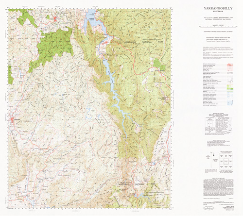
Yarrangobilly 1-100,000 Topographic Map
Price range: $13.95 through $28.95
Description:
Locations within this Map
Batlow Cabramurra Talbingo Tumbarumba Atkinsons Flat Atkinsons Creek Ash Gully Ash Creek Andrews Gully Appletree Gully Acacia Creek Adelong Creek Back Creek Back Creek Left Branch Back Gully Bago Range Bago State Forest Baileys Gully Bald Hill Basin Creek Batlow Central School Batlow Post Office Batlow Railway Station Batlow Showground Beaumont Beebys Gully Big Bogong Mountain Big Creek Big Gunyam Creek Big Hill The Big Plain Big Plain Big Plain Creek Big Plain Peak Big Stringybark Mountain The Big Stringy Bark Big Talbingo Big Talbingo Mountain Bobtail Gully Blakes Creek Blue Creek Black Perry Creek Black Perry Mountain Mount Black Jack Black Jack Creek Black Jack Bloomfield Creek Black Gully Black Creek Boggy Creek Boggy Gully Bogong Mountain Bogong Peaks Boltons Creek Boltons Hill Boomerang Creek Boonoo Creek Boonoo Gully Boraig Boundary Creek Boxes Gully Brandy Mary Spur Brennans Creek Brennans Gully Bridle Creek Bridle Gully Bridle Mountain Broadhursts Creek Brownleys Back Creek Brownleys Creek Buccleuch Buchanans Creek Buchanans Gully Buddong Buddong Creek Buddong Falls Buddong Range Buddong Ridge Bull and Damper Creek Cabramurra Landing Ground Cabramurra Public School Cave Creek Cave Gully Chambers Creek Charcoal Gully China Walls Christians Gully Clarkes Gully Clarkes Hill Clear Creek Clydes Creek Cockneys Creek Cockneys Spur Coffee Pot Commissioners Gully Corduroy Gully Coultons Creek Courabyra Cowra Crack Hardy Point Cumberland Break Cumberland Creek Cumberland Gap Cumberland Range Dallans Gully Dalys Creek Dead Mans Ridge Deep Creek Deep Creek Dam Deep Gully Devils Gully Dunns Gully Dunns Hill East Burra Creek Eight Mile Creek Eurabbie Gully Faheys Creek Fifteen Mile Creek Foxes Creek Free Damper Creek Frenchmans Creek Frikes Creek Gannons Creek Gap Creek Gap Gully Garden Gully Mount Garland Geordies Ridge Giandarra Gully Gibsons Plains Glendower Creek Glory Hole Cave Goat Ridge Goldies Gully Goodmans Gully Gordons Gully Gormans Gully Granite Granite Mountain Gurkeroo Ridge Hammonds Gully Happy Valley Creek Hardys Mill Hardys Sugarloaf Harrisons Gully Hay Hickory Creek Highground Creek High Rock Lookout Honeysuckle Creek Howards Gully Hume and Hovell Lookout Hussels Gully Hyde Inspiration Lookout Inspiration Point Jagumba Jagumba Creek Jagumba Mountain Jersey Cave Jillabenan Cave Johnsons Gully Jounama Jounama Creek Jounama Dam Jounama Pondage Kellys Creek Kellys Gully Keoghs Ridge Cabramurra Airstrip Cave or Clive Creek The China Walls Clarks Gully Corduroy Creek Cowra Creek or Paddys River Dallans Creek Eight Mile Dam/ Eight Mile Lagoon Eurabbie Creek Faheys Gully Feathertop Round Top Fifteen Mile Spur Head of Four Mile Creek Freedamper or Middle Creek Frenchman Creek Geordies Spur Giandarra Creek Gilmore Sheep Station Creek Gordons Creek Gormans Creek Hickory Gully Horse Creek Keoghs Range Kiandra Kiandra Plain King Kings Cross Kosciusko National Park Kunama Kunama Railway Station Village of Kunama Lagoon Gully Lampe Lampes Creek Lampes Corner Landers Creek Landers Falls Larrys Creek Larrys Ridge Laurel Hill Laurel Hill Public School Leos Creek Lick Hole Creek Lick Hole Gully Lindsays Creek Little Buddong Creek Little Gilmore Creek Little Glory Hole Creek Little Plain Little Talbingo Lobs Hole Logbridge Creek Long Creek Long Jacks Hill Loughlins Gully Lyne Park Mackays Gully Mccabes Creek Mccredies Gully McGeochs Creek Mcgregors Creek Mcgregors Gully Mcphersons Plain Maddens Creek Madmans Gully Main Creek Main Range Majuba Hill Malabar Mountain Mandys Creek Manjar Manjar Creek Mannus State Forest Maragle Creek Maragle Maragle Back Creek Maragle Hill Maragle Mountain Maragle Range Maragle State Forest Marica Mettys Gully Mica Creek Mica Gully Michelago Michelago Peak Middle Creek Middle Ridge Milkmans Creek Milk Shanty Milk Shanty Creek Mill Creek The Mill Creek Millers Gully Mitchell Gully Modder Creek Modder River Sparkes Creek Moody Moodys Hill Mount Ash Creek Mount Maragle Mullins Gully Murphys Creek Murphys Gully Murrays Gully Native Dog Creek Natural Bridge New Chum Hill New Maragle Creek New Maragle Hill New Maragle State Forest New Zealand Gully Nine Mile Creek Head of Nine Mile Creek Nurenmerenmong Nutt Gully O’Hares Creek O’Hares Hill O’Hares Ridge O’Hares Spur Oldmaragle Old Yachting Point Paddys River Paddys River Falls Paddys River Dam Paddys Rock Palace Saddle The Palace Parsons Gully Patrick Gully Pells Gully Pennyweight Creek Permanent Creek Perrots Flat Piding Creek Pillared Rock Ridge Pillared Rock Range Pilot Hill Pilot Reef Mountain The Pilot Reef Pinbeyan Pinbeyan Creek Pinbeyan Ridge Pinchgut Creek Pipeclay Hill Plain Creek Pleasant Gully Plot Creek Plot Gully Poison Rock Creek Pollocks Creek Possum Point Mountain Pound Creek Pounds Creek Pound Ridge Powers Creek Prospector Creek Pub Creek Pub Gully Quartzville Racecourse Creek Ravine General Cemetery Village of Ravine Ravine Razorback Ridge Reeds Creek Reeds Hill Reedy Creek Reedy Flat Reef Creek Reids Creek Richardsons Creek Ridings Creek Right Branch Rings Creek Rocky Creek Rocky Gully Rough Creek Round Hill Round Top Mountain Ruby Creek Rutherfords Ridge Rutherfords Range Sailors Gully Sandy Creek Sandy Gully Sawpit Creek Sawpit Gully Scotch Creek Scotch Gully Scotchmans Creek Scotchmans Gully Section Creek Section Ridge Selwyn Settlement Creek Shaw Hill Shay Creek Shay Gully Sheep Station Creek Sheep Station Gully Sheep Station Ridge Sheepyard Creek Shores Gully Shortridge Creek The Sisters Skeleton Creek Skeleton Gully Smalls Gully Snow Ridge Snubba Snubba Creek Somersault Creek Somersault Gully Sparkes Creek Sparkes Gully Sparkes Plain Spencers Creek Spring Creek Spurgeons Gully Stable Creek Stable Walls Steep Gully Stockmans Creek Stockmans Gully Stockyard Gully Stony Creek Storm Lookout The Storm Lookout Sue City Sue City Camp Sugarloaf Sugarloaf Spur The Sugarloaf Table Top Talbingo Dam Talbingo Mountain Talbingo Post Office. Talbingo Public School Talbingo Reservoir Tarcutta Swamp Temperance Creek Temperance Ridge Temperance Spur The Cliffend Walls The Devils Gully The Five Corners The Gulf The High Ground The Island The Nine Mile The Pipe Clay Hill The Racecourse The Sounding Ground The Yarrangobilly Caves Three Mile Creek Three Mile Dam Toll Bar Ridge Tommies Plain Creek Tomneys Plain Tomneys Plain Creek Toolong Range Tooma Tooma Public School Tooma River Town of Tumbarumba Tumbarumba Cemetery Tumbarumba Creek Tumbarumba General Cemetery Tumbarumba Golf Course Tumbarumba High School Tumbarumba Hill Tumbarumba Post Office Tumbarumba Public School Tumbarumba Racecourse Tumbarumba Showground Tumut Pond Dam Tumut Pond Reservoir Tumut Two Pondage Two Mile Creek Two Mile Hill Union Jack Race Walker Creek Wallace Wallaces Creek The Walls Wambat Gully Wangara Gap Wargunyah Creek Warm Spring Weir Creek Weir Gully Welumba Welumba Hill Whipstick Creek Whipstick Gully White Horse Creek Wickhams Gully Wild Duck Creek Wild Duck Gully Wild Horse Ridge Wild Mares Creek Wild Mares Gully Wilkinsons Creek Willigobung Swamp Wombat Gully Worlds End Yans Creek Yans Crossing Yans Gully Yarrangobilly Yarrangobilly Caves Yarrangobilly Village Of Yellow Bog Creek Yellow Creek Yellowin Creek Yorkers Creek Bull Hole Creek Bullock Head Creek Bullocks Head Creek Bulls Flat Bulls Flat Creek Doctors Creek Dog Creek Doughtys Gully Dry Dam Dry Gully Duffer Gully Duffers Gully Doughty Gully Dry Creek Burns Creek Burnt Gully Burra Burra Creek Burra Creek Left Branch Burra Creek Right Branch Burra Ridge Byron Byrons Range Byrons Ridge Bago Flora Reserve Paddys River Flora Reserve Helms Flora Reserve Pegmill Creek Yellowin Forest Park Jounama Forest Park Mansfield Gully Batlow Technology School Beebys Creek Willigobung Bogong Peaks Wilderness Back Maragle Creek Horse Gully Stoney Creek The Pipeclay Hill Mcgregors Brownleys Creek Kiandra Creek Kosciuszko National Park The Pilot Wybalena Bogong Mountain Range Yellowin Budding Falls Pineview Yarrangobilly Cave Yarrangobilly River OHares Hill Greenwood Akuna Cowra Creek Glenbrook Eight Mile Dam Mannus Creek Mount Jagumba Kosciusko State Park
| Name: | Yarrangobilly |
| Publisher: | Geoscience Australia (Australian Government) |
| Scale: | 1:100000 |
| Latitude Range: | 35° 30.0′ S – 36° 00.0′ S |
| Longitude Range: | 148° 0.0′ E – 148° 30.0′ E |
| Projection / Datum: | Universal Transverse Mercator, GDA94 |
| Approx Print Size: | 0.56m X 0.56m |
| Publication Date: | 1977 |