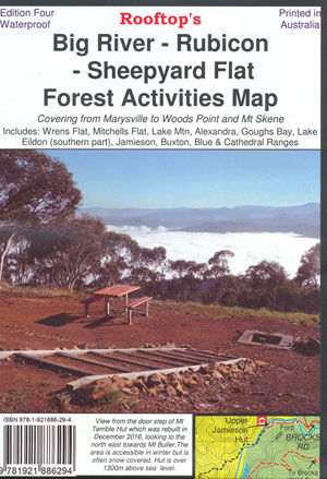
Big River Rubicon Forest Activities Map Rooftop
$14.95
Description:
Big River Rubicon Forest Activities Map Rooftop
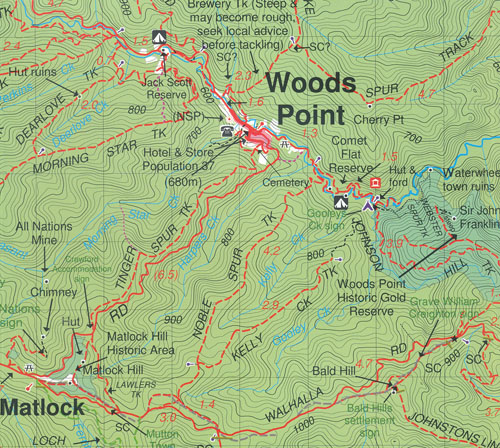
For the 2018 edition 4, the original Big River – Rubicon Rooftop map has been extended to cover the Upper Goulburn and Jamieson Valleys. The map is now double-sided providing the user with even more value for money. One side includes Big River, Woods Point, Big River Arm of Lake Eildon, Jamieson, Gaffneys Creek and Enoch Point, Wrens Flat, Mitchells Flat, Lake Mountain, Buxton, Blue Range, Cathedral Range, Southern Part of Lake Eildon, Mt Skene Scenic Reserve, Howqua River, Howqua Hills, Sheepyard Flat, Knockwood, R2 Lookout, The Low Saddle. Jamieson River, A1 Settlement, Black River, Matlock, Frenchmans Creek
The other side includes Narbethong, Lake Eildon, Alexandra, Stockmans Reward, Marysville, Eildon, Blue Range and Rubicon,Jerusalem Creek, Thortnton, Rubicon, Mount Torbreck, Big River, Acheron, Taggerty, Lake Mountain Alpine Resort, Mt Bullfight, Big River Camp, Granton, Steavensons Falls, Mt Margaret, Cambarville, Shaws to Oaks Inset Map.
Scale is 1:50,000 with contours.
All the usual Rooftop information has been included with lots more notes and places of interest.
Edition 4
Published 2018
ISBN 98781921886294
Printed on Waterproof Paper
You may also like…
-
Jamieson Licola Adventure Map Rooftop
Price range: $11.95 through $25.00Select options This product has multiple variants. The options may be chosen on the product page -
Walhalla Woods Point Adventure Map Rooftop
Price range: $12.95 through $25.00Select options This product has multiple variants. The options may be chosen on the product page