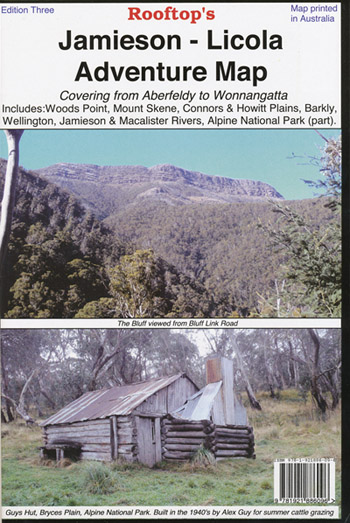
Jamieson Licola Adventure Map Rooftop
Price range: $11.95 through $25.00
Description:
Jamieson Licola Adventure Map Rooftop
Explore the Upper Goulburn, Jamieson & Licola region as you’ve never seen it before.
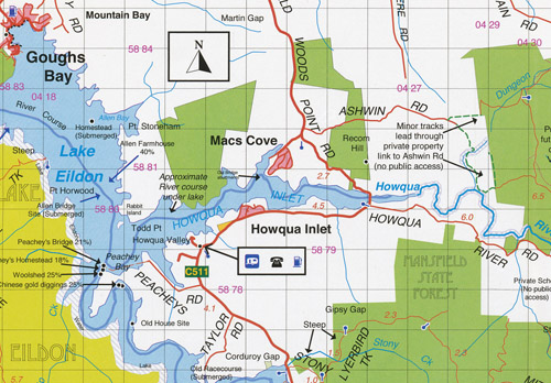
Map coverage is from Goughs Bay, Jamieson and the Howqua River in the north to the Upper Thomson, Aberfeldy and Licola in the south. It includes Woods Point, Mount Skene, Alpine National Park, Wellington, Jamieson, Macalister and Thomson Rivers, Connors and Howitt Plains, Goughs Bay, Howqua Inlet, Enoch Point, Gaffneys Creek, mbtg Matlock, A1 Mine Settlement.
Scale is 1:100,000.
The reverse of the map has a 1:50,000 scale enlargement titled ‘Jamieson – Sheepyard Flat Forest Activities Map’ with contours. Also The Bastards Neck, Caladonia River Track, High Cone, Lickhole Creek Walking Track, Mt Darling, Mitchells Homestead, Mt Skene Scenic Reserve, Mt Sunday, The Low Saddle, mbtg, Whiskey Knob Mining Camp, Mt McDonald, Parts of the Alpine Walking Track, Chesters Hut, Saltlick Saddle, The Bluff and Bluff Hut, Lovicks Hut, Mount Lovick, King Billy No1, Mt Magdala.
All parks, reserves and state forests are shown and all roads and tracks have been plotted using GPS mapping technology.
Edition 3 Published December 2012
ISBN 9781921886096
The Rooftop Jamieson Licola Adventure Map is also available Laminated
You may also like…
-
Mansfield Mt Howitt Map Rooftop
Price range: $8.95 through $17.00Select options This product has multiple variants. The options may be chosen on the product page -
JAMIESON SOUTH 1-25,000 Vicmap Topo Map 8123-3-S
Price range: $14.00 through $26.00Select options This product has multiple variants. The options may be chosen on the product page -
Walhalla Woods Point Adventure Map Rooftop
Price range: $12.95 through $25.00Select options This product has multiple variants. The options may be chosen on the product page -
Skene 1-50,000 Vicmap
Price range: $12.00 through $24.00Select options This product has multiple variants. The options may be chosen on the product page -
JAMIESON NORTH 1-25,000 Vicmap Topo Map 8123-3-N
Price range: $14.00 through $26.00Select options This product has multiple variants. The options may be chosen on the product page