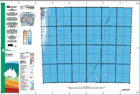
Bodalla 1-1,000,000 Topographic Map GA
Price range: $16.95 through $28.95
Description:
Bodalla 1-1,000,000 Topographic Map Geoscience Australia
1: 1 Million General Reference Topographic Map Print on Demand
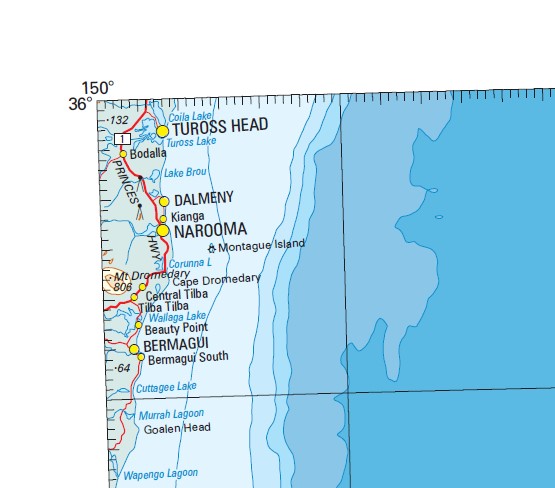
MAINLY SEA
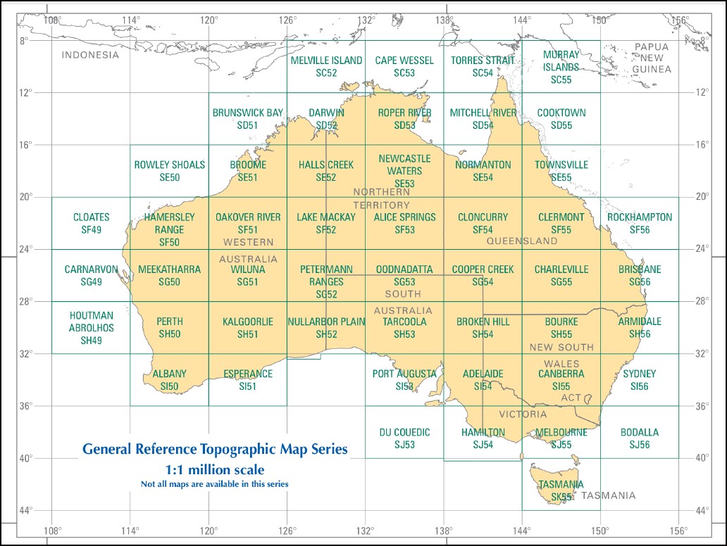
This map is part of a series which comprises 50 maps which covers the whole of Australia at a scale of 1:1 000 000 (1cm on a map represents 10km on the ground). Each standard map covers an area of 6 degrees longitude by 4 degrees latitude or about 590 kilometres east to west and about 440 kilometres from north to south. These maps depict natural and constructed features including transport infrastructure (roads, railway airports), hydrography, contours, hypsometric and bathymetric layers, localities and some administrative boundaries, making this a useful general reference map.
Beauty Point Bermagui Bodalla Dalmeny Narooma Tuross Head Wallaga Lake Mystery Bay Wallaga Lake Heights Potato Point Araganui Bay Aragunnu Bay Aragunnu Beach Aragunnu Creek Amherst Island Amhurst Island Arnolds Creek Arnolds Gully Armands Bay Baragoot Beach Baragoot Lake Baragoot Point Bar Beach Barlows Bay Baronda Head Barragga Bay Barragga Point Barunga Point Barunguba Beares Beach Ben Boyd National Park Bermaguee Bermaguee State Forest Bermagui Nature Reserve Bermagui Public School Billa Bilba Creek Bodalla Public School Bodalla State Forest Bobundara Swamp Bobundura Swamp Bobundara Creek Blue Pool Blackfellows Point Black Bream Point Bithry Inlet Bittangabee Bay Lake Birroul Bingie Beach Bingie Bingie Point Binge Binge Point Boggy Creek Bogola Head Boogumgoridge Point Borang Creek Borang Lake Boro Lake Borrong Lake Borung Lake Brices Bay Brobothalle Brobothalle Point Brockelos Creek The Brothers Brou Beach Lake Brou Brow Beach Brow Creek Lake Brow Lake Brunderee Brush Lake Cambathin Island Camel Rock Cemetery Point Central Tilba Central Tilba Public School Charleys Gully Clarks Bay Cobra Mountain Comerang Cooper Island Coppins Creek Coradge Point Corunna Corunna Lake Corunna Point Corunna State Forest Couria Bay Couria Creek Cowdroy Creek Cuttagee Beach Cuttagee Lake Cuttagee Point Evans Point Fairhaven Flying Fox Bay Forsters Bay Frenchmans Gully Freshwater Bay Fullers Beach Ginns Lookout Glasshouse Rocks Goalen Head Goura Nature Reserve No. 47 Grants Lookout Grassy Hill Green Cape Green Cape Lighthouse Growlers Gully Hayward Point Haywards Beach Hobbs Bay Hobbs Point Horse Island Horseshoe Bay Jabarrah Point Jaggers Bay James Creek Jemisons Beach Jemisons Point Jerimbut Point Keatings Headland Callo Point Charleys Creek Coila Beach Corrunna Point Eurungona Fosters Bay Four Mile Beach Fresh Water Lake Handkerchief Lake Horse Shoe Bay Karea Creek Kianga Kianga Creek Kianga Estate Kianga Lake Kianga Point Killarney Bay King Merriman Island Aboriginal Place Lavender Point Lawlers Creek Little Bumbo Creek Little Dromedary Creek Dromedary Hill Little Lake Long Swamp Loader Beach Long Beach Ly-Ee Moon Cemetery Ly-Ee Moon Graveyard Makins Creek Makins Hill Marka Point Marka Matthews Creek Meringo Beach Merriman Island Middle Beach Middle Lagoon Middle Lake Mill Beach Mimosa Rocks Montague Island Montagu Island Montreal Mount Dromedary Flora Reserve Mowarry Point Mummuga Mummuga Creek Mummuga Head Lake Mummuga Murrah Murrah Beach Murrah Head Murrah Lagoon Murrah Lake Murrah River Murrah State Forest Murunna Point Myrtle Gully Nangudga Lake Nargal Lake Narooma Beach Narooma General Cemetery Narooma High School Narooma Post Office Narooma Public School Nerrigundah Naorooma Noorooma Noorooma General Cemetery Noorooma Public School Northern Branch of Bumbo Creek Nouben Point Nouben Nugget Head Nuttal Lake Olsons Creek One Tree Rock Page Islets The Pages Paradise Point Peacocks Crossing Piccaninny Beach Picnic Beach Picnic Point Pig Island Pitmans Creek Pooles Creek Potato Beach Potato Creek Punkalla Punkally Creek Rats Head Creek Reedy Island Regatta Point Ringlands Bay Ringlands Point Rose Bay Shell Point Silvestris Flora Reserve Skelton Skelton Hill Snake Island Stony Creek Surf Beach Tanja Tanja Lagoon Tarandore Point Lake Tarourga Thubbul Tilba Tilba Lake Tilba Tilba Tilba Tilba Lake Tommys Bay Trunketabella Turlinjah Tuross Lake Umeboro Island Victoria Creek Wagonga Wagonga Head Wagonga Hill Wagonga Inlet Wagonga River Wagonga Lake Wajurda Point Wallaga Lake National Park Wallaga Lake State Park Wapengo Lagoon Wapengo Lake Waramba Rocks Wedget Plain Whittakers Creek Dignams Creek Dingo Hole Yellow Creek Yellow Gully Yellow Hill Yum Point Zane Grey Pool Bullengella Lake Bumbo Bumbo Creek Bumbo Lake Dromedary Dromedary Creek Little Dromedary Mountain Mount Dromedary Deuaumba Island Bundooro Bunga Bunga Beach Bunga Head Bunga Lagoon Bunga Lake Bunga Pinch Road Buro Buro Point Burrimbidgee Creek Akelelee Akolele Baragoot Creek Bar Rock Lookout Bermagui Flora and Fauna Reserve Bermagui Harbour Bermagui North Lagoon Bermagui River Bermagui South Lagoon Black Creek Black Lagoon Boat Harbour Point Bounds Bay Bounds Creek Bowns Creek Bowns Bay Breakaway Beach Brothers Rocks Bucks Lookout Buckeridge Lookout Cape Dromedary Carters Beach Coolagolite Creek Dickinson Recreation Reserve Dignams Swamp Duesburys Point Fairhaven Inlet Fishermans Bay George Noble Park Handkerchief Beach Harold Buckeridge Lookout Honeymoon Bay Honeymoon Point Jaggers Beach Kianga Beach Kings Corner Kitchen Hole Little Cuttagee Lake Main Beach Mangans Creek Meads Bay Meads Creek Merriwinga Creek Mill Bay Moorhead Beach Montague Island Lighthouse Myrtle Bay One Tree Beach Pebbly Beach Pigs Crossing Point Dickinson Shallow Lake Snake Flat The Broadwater Three Brothers Rocks Trunketabella Creek Trunketabella Flat Trunketabella Lake Tuross Broadwater Bengunnu Point Trunkedabella Plain Chatham Park Clive Park Dalmeny Beach Dorl Bay Duesburys Beach Freds Island Gillards Beach Penders Beach Potato Point Beach Yabbara Beach Yabbara Point Montague Island Nature Reserve Gulaga Flora Reserve Romays Island Monaro Point Golden Gate Iron Reef Joshs Beach South Tuross Beach Bermagui Point Michael Lerner Lookout Bermagui Lagoon Bermagui State Forest The Gut Old Jetty Bay Jetty Bay Dalmeny Rotary Park Coila North Narooma Cuttagee Bingie Eurobodalla National Park Bill Robinson Park Coila Lake Coila Bar Spring Creek Narooma Quota Park Cresswick Cove Stinking Bay Dori Bay Wallaga Beach Flathead Bay Long Bay Green Bay School Point Snapper Point Honeysuckle Island Hawkes Nest Cowrie Beach Shelly Beach Blue Point Jack Common Beach Hegartys Bay Comerang Reach Ferry Crossing Park Lake View Mullimburra Point Mullinburra Point Tuross Heads Tuross Inlet Tuross River Turos River Barbunga Point Marka Point Mark Point Burra Lake Minmuga Lake Yellow Head Bogolo Head Nugget Point Aughinish Rock Boat Harbor Point Ajungagua Hill Goura Nature Reserve Number Forty-Seven Bermagui Bay Wallagal Lake Wallage Lake Walluga Lake Narira Creek Burragat Rocks Baragga Point Erungona Creek Dry River Goalen Point Mimosa Rock Callo Tanya Lagoon Mowwarry Point Bitangabee Creek Nelsons Plains Muddy Creek The Basin Blind Cove
| Name: | Bodalla |
| Publisher: | Geoscience Australia (Australian Government) |
| Scale: | 1:1000000 |
| Latitude Range: | 36° 00.0′ S – 40° 0.0′ S |
| Longitude Range: | 150° 0.0′ E – 156° 0.0′ E |
| Projection / Datum: | Lambert Conformal Conic, GDA94 |
| Approx Print Size: | 0.44m X 0.67m |
| Publication Date: | 2013 |