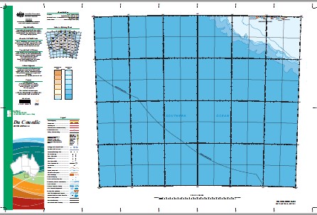
Du Couedic 1-1,000,000 Topographic Map GA
$16.95
1 in stock (can be backordered)
Description:
Du Couedic 1-1,000,000 Topographic Map Geoscience Australia
1: 1 Million General Reference Topographic Map Print on Demand
MAP MAINLY SEA
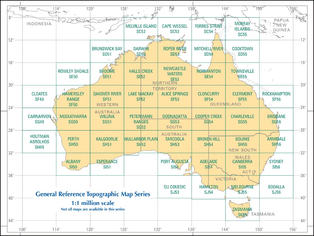
This map is part of a series which comprises 50 maps which covers the whole of Australia at a scale of 1:1 000 000 (1cm on a map represents 10km on the ground). Each standard map covers an area of 6 degrees longitude by 4 degrees latitude or about 590 kilometres east to west and about 440 kilometres from north to south. These maps depict natural and constructed features including transport infrastructure (roads, railway airports), hydrography, contours, hypsometric and bathymetric layers, localities and some administrative boundaries, making this a useful general reference map.
Althorpe Canyon Du Couedic Canyon Couedic Canyon De Couedic Canyon Gambier Canyon Gantheaume Canyon Kangaroo Canyon Lincoln Canyon Murray Canyon Neptune Canyon Pearson Canyon Seal Canyon Spencer Canyon Sprigg Canyon Topgallant Canyon Whidbey Canyon Young Rock North Rock Stun’Sail Boom Quin Rock Atalanta Woody Range North West Snares Stun’sail-Boom River Stunsail Boom River Cape Linois Pudna Pointe du Pincon Hindmarsh District High School Pilchera Bore School Wheatleigh Primary School Piddington Special School Sunny Hill Primary School Pelican Point Primary School McDonald Railway Station Yatala Reef Yertamaiyo Wildflower Narhanna Well Lake Kitty The Parks High School Stony Grove School Hills Christian Community School Stockwell-Modbury Primary Schools Camp Site Sunbury Primary School Concord School Belvidere Primary School Diamond Lake Primary School Strong Bay Wandra-Brin-Nannie South East Community College Wanappe Pondoothy Rosatala Ulalpauidkee Yungga-Umburrumburri Hindmarsh Reservoir Douglas Railway Station Eden Park Special School Harrigan Gap Mount Watson Alabaster Post Office Murraylands College of TAFE Yanderby Rockhole Elizabeth Rebecca Freebridge War Dar Gunna Onkaparinga Plains Lords Dam Thomas Reservoir Murri Murri Ando Hornets Nest Homestead Beachs Gow Creek Walpunyie Rockhole Benlo Tuckinga Peck Hill Rosetta Cove Wooley Block Peela Tank Wirlpana Railway Station Stadlunga Lorna Glen Perukila Hill Hayes Range Kammaroo Watson Park Sanderson Bay OG Agneta Yaldyilinha Wandina Kadlunga Noonameena School Yattagolinga Mine Overland Camp Springs Ity-A-Mudkie Lake Seymour Whalebone Head Zanoni Remarkable Rocks Psyche Go-De-Rannie Creek Tilleys Accommodation House Wurtun Railway Station Stony Plain Wirpa Railway Station Urea Cowie Hill Pedinga Ngurralanha Cape Bouger Warumba Tuna-midi Kundanyimbo Rufus Creek Tungkillo-Daperoo Primary School Camp Site Spencer Junction Railway Station Woonamulla Yarraville School Tigress The Pinery Tilkola Yakati South-West River Pointe des Aiguilles Forrester School Marlka Vari Virdnivirdni-Nurranha Rose Widapa Awi Urtu Rosetta Bay St Cecelia Creek Spencer Institute of Vocational Education Stun’Sail Boom Beach Cape du Couedic Cap du Couedic Dry Creek South East Snares Peg Gap Gullett Hut Governor Musgrave Lighthouse Pinefield School Yantawena Gilliston Osmond River Cotanaranna Water Nicholson Avenue Junior Primary School River Light Primary School Mora Mora School Light-Riverland Institute of Vocational Education Rail Point Burnside Lower Reservour Cape de Couedic Lighthouse Match Hill Arachne Umera Vivonne Bay Conservation Park White Flat Primary School Oaks Primary School Salt Creek Rural School Moorowie Primary School South Road Junior Primary School Pioneer-Woodleigh School Moopina Pointe de le Savane Mount Brizell Primary School Tenafeate Primary School Koninderie Railway Station Cottabidnya Spring Hill Paisley Well Perrichina Station Pitfall Hill Stun’Sail-Boom River Southern Kangaroo Island Marine Park Weirs Cove Summit Railway Station Ward Crossing Open Access College Ooldabinna Gass Bird Sanctuary Kirkpatrick Point Weir Cove Pine Cap Gantheaume Wanama Breeze Point Pretoria Pine Comb Flat Mount North East Muralappi Railway Station Tuni Railway Station Nukulla Point Phillips Lands End Conservation Park Warriapendi Alternative School Advanced School For Girls Boundary Creek School Beitirie-Ma-Lunie Hall Gully Cap South South West Rock Lander Creek Hermitage Wodliparri Port Willson Rivers Creek Little Totness Cuddubaien Port Clare Pointe des Requins Lovely Valley School Murray Institute of Vocational Education Brightwood Primary School Millbrae Primary School Young Surveyor Venture Milleyoora Werridi Marara The Brothers Barmeedki Bunker Hill Ulgar Railway Station Tank Cave Hawkers Creek Toopwarinna Thompson Flat Blumenthal Hampdeon Primary School Shoal Bay Primary School Woodside Camp Primary School Grey Point Pretoria Place Loch Sloy Yacca Flat Hills College of TAFE Yantaringa Railway Station Tuckamana Narragogoonnoo Mooku Cape Gantheaume Cave Point North West Snare South East Snare Baram-Nerrany Bumbeyadna The Little Plains Mungala Railway Station Pointe des Pigrieches Nilyuntana Primary School Dollings Corner School Woods Primary School South Downs Primary School Beau Vale Primary School Boodnemunna Tundroo Railway Station Kerno Reynolds Grove Park Hill Boucauts Folly Witawirra Anti-Wocarra Cape Bouguer Wilderness Protection Area Pirlakaya Jervois West Primary School Ngapla Primary School Pointe de la Reprise Mount Melville Primary School Whyalla Onkaparinga Institute of Vocational Education South West River Sandy Lake White Hut School Murraylands Campus Pelorus Islet Pine Forest Riverland College of TAFE Lowanna Railway Station Peters Hill Primary School Gum Vale Primary School Wingfield Camp School Wingelbunna Raglan Primary School Cap Linois Douglas Reef Mount Ellen Lake Cardivallawarracurracurrieappalarndoo Undaganie Arannie Point Debuy Watts Creek Hansen Bay Sea Cave Gillen Public School Scaddon House Salt Lake School Maitpa-Ngga Point Wilson New Discovery O’Halloran Creek Twenty Eight Mile Tank Mutooroo Railway Station You Yangs Mississipi River Pointe des Adieux Woorolong Primary School Maryvale Yertabukko Winnininnie Hill Light College of TAFE Yorke Peninsula College of TAFE James A Nelson School Yernayerna Tiers D’etat Mobilong Campus Moolkarra Tracoona Native Well Hanson Bay Cape Kersaint Cape Younghusband Cape Bouguer Cape de Coudie Admirals Arch Casuarina Islets Douglas Rock Grassdale Grasslands Station Point Ellen StunSail Boom Beach Sou West River N.W. Snare Kilpatrick Point Cape Du Couedic Cape Couedie Casuarina Island Casuarina Islands S.E. Snare Quia Rock Pelorus Island Lipson Reef Young Rocks
| Name: | Du Couedic |
| Publisher: | Geoscience Australia (Australian Government) |
| Scale: | 1:1000000 |
| Latitude Range: | 36° 00.0′ S – 40° 0.0′ S |
| Longitude Range: | 132° 0.0′ E – 138° 0.0′ E |
| Projection / Datum: | Lambert Conformal Conic, GDA94 |
| Approx Print Size: | 0.44m X 0.67m |
| Publication Date: | 2013 |