Broome 1-250,000 Topographic Map
Price range: $15.95 through $30.95
Description:
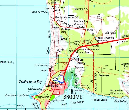
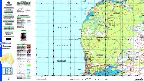
This 1-250,000 topographic map is part of the series that covers the whole of Australia at a scale of 1:250 000 (1cm on a map represents 2.5 km on the ground) and comprises 513 maps. This is the largest scale at which published topographic maps cover the entire continent. Each standard map covers an area of 1.5 degrees longitude by 1 degree latitude or about 150 kilometres from east to west and 110 kilometres from north to south. There are about 50 special maps in the series and these maps cover a non-standard area. Typically, where a map produced on standard sheet lines is largely ocean it is combined with its landward neighbour. These maps contain natural and constructed features including road and rail infrastructure, vegetation, hydrography, contours (interval 50m), localities and some administrative boundaries. The topographic map and data index shows coverage of the sheets. Product Specifications Coverage: The series covers the whole of Australia with 513 maps. Currency: Ranges from 1995 to 2009. 95 of maps have a reliability date of 1994 or later. Coordinates: Geographical and either AMG or MGA (post-1993) Datum: AGD66, GDA94, AHD. Projection: Universal Traverse Mercator (UTM) Medium: Paper, flat and folded copies.
Broome 7 Mile Bore Alistairs Bore Anastasias Pool Andys Bore Baldwin Creek Baldwin Creek Mill Barlee Spring Bore Barred Creek Barred Creek Bore Baskerville Shoal Bedford Park Bells Tower Bernis Bore Bilgungurr Community Bilingurr Billignuru Black Ledge Black Tank Bohemia Bore Boileau Patches Brolga Park Broome Airport Broome Bird Observatory Broome Community Health Services Broome Golf Club Broome Primary School Broome Senior High School Buccaneer Rock Buckleys Bore Budgarjook Community Bull Gate Bore Bunda Bunda Mill Burrgugun Community Cable Beach Cable Beach Primary School Cable Beach Reserve Cape Baskerville Cape Bertholet Cape Boileau Cape Latreille Carnot Bay Carnot Bay Spring Carnot Peak Carnot Springs Community Cary Patch Charlies Bore Chippindall Park Clarksons Bore Cockle Well Collins Bore Collins Creek Collins Lagoon Cookes Pillar Coulomb Point Coulomb Point Nature Reserve Country Downs Country Downs Mill Cow Bore Crab Creek Cygnet Park Dakas Park Dampier Dampier Creek Dampier Peninsula Declaration Rock Deep Creek Deep Creek Bore Demco Park Djibbinj Community Djugun Duncan Bore East Hole Bore Escape Rocks Fall Point False Saddle Hill Farm Shoal Fishermens Bend Flow Dam Frog Hole Bore Gantheaume Point Gantheaume Point Light Goodjara Bore Goolarabooloo Community Government Cow Bore Grey Shoal Grotte Bore Gurumbul Bore Hays Bore Home Bore Horsewater Soak Horsewater Well Inner Anchorage Jabir Jabir Community James Price Patches James Price Point Jarangar Jerricop Bore Jones Place Joseph Well Kennedys Cottage Kilto Kilto Microwave Repeater Station Kimberley Camp School Kimberley Region King Peaks Kirby Gardens Kurrajong Bore Lake Campion Lake Campion Bore Lake Eda Lake Eda Point Tank Lake Louisa Lawrence Park Lookout Hill Low Sandy Point Lower Loominggum Bore Mackie Park Mallingbar Community Mamabulanjin Community Manari Mangrove Point Maritana Park Mcmahon Reserve Melaleuca Miller Park Minyirr Monbon Community Moorak Bore Morard Bore Morard Community Morrells Park Community Mount Jowlaenga Mundud Community Nab Rock Naringla Shoal Neds Bore New Pollys Bore New Seven Mile Bore Nillir Irbanjin Community Nimalarragun Claypan No. 1 Bore No. 10 Bore No. 2 Bore No. 3 Bore No. 4 Bore No. 5 Bore No. 6 Bore North Rock Nudugun Community Panton Shoals Peter Haynes Reserve Pioneer Cemetery Planigale Park Poinciana Well Quarry Dam Quondong Beach Quondong Point Reactor Lodge Red Bluff Red Hill Red Point Riddell Beach Riddell Point Roadhouse Corner Roebuck Roebuck Bay Golf Club Roebuck Deep Roebuck Microwave Repeater Station Roebuck Plains Roebuck Primary School Saddle Hill Sam Male Reserve Sayonara Park Sibosado Park Skuthorpe Smirnoff Beach Solway Park Spookhole St Marys College Station Hill Sugar Glider Park Sunset Park Swirl Rock Tagarana Bore Talboys Rock Tangier Shoals Taylors Lagoon Taylors Lagoon Bore Tolentino Park Town Beach Reserve Two Wells Tyre Corner Ungani Bore Ungani Lakes Ungani Well Upper Loominggum Bore Van Tuyn Point Vincent Well Wanganut Spring Outcamp Waromberni Bore Waterbank West Roebuck Whale Rock Wibajaba Well Willagree Park Willie Creek Willie Creek Pearl Farm Woods Park Yulleroo No. 1 Oil Well Yulleroo Well Baldwin Well Josephs Well Bungadoc Tangier Shoal Nevilles Well Palm Farm Bunda Bunda Well Panton Reef Panton Shoal Chowtengan Spring Talboy Rock Green Hillock Red Cliffs Wanganut Well Dampier Land Number Three Bore Chinki Well Bones Well Willy Creek Hill Hill Station Low Point Loomungun Well Loo-mun-gun Spring Leanwarringah Well Roebuck Roadhouse Barlee Spring Barley Spring Gantheaume Bay Edah Lake Elliot Lake Duncan Well Station Head Paterson Well Prospectors Well One Mile Tank Unguni Bore Unquni Bore Escape Rock Cape Huygens Pearl Shoals Bittern Rock Broome Harbour Beacon Hill Beacon Head
| Name: | Broome |
| Publisher: | Geoscience Australia (Australian Government) |
| Scale: | 1:250000 |
| Latitude Range: | 17° 0.0′ S – 18° 00.0′ S |
| Longitude Range: | 121° 30.0′ E – 123° 0.0′ E |
| Projection / Datum: | Universal Transverse Mercator, GDA94 |
| Approx Print Size: | 0.44m X 0.67m |
| Publication Date: | 1-Jun-03 |