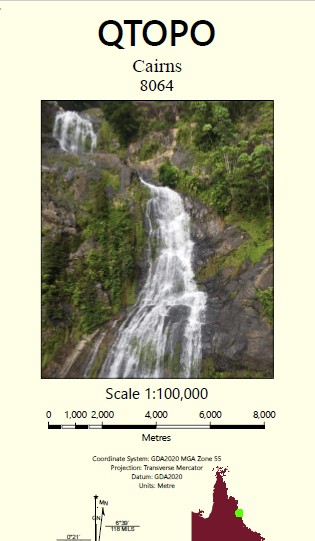
Cairns 1-100,000 Topographic Map
Price range: $15.95 through $30.95
Description:
Locations within this Map
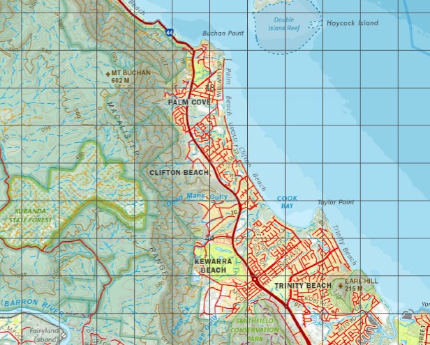
Oyster Reef Pixie Reef Spring Valley Snake Gully Speewah Caravonica Cairns Kuranda Smithfield Heights Yarrabah Admiralty Island Aeroglen Alligator Creek Arnold Knob Avondale Creek Bare Hill Barr Creek Barron Beach Barron Falls Barron Gorge National Park Barron River Beebo Peak Bessie Falls Bessie Point Big Rooty Creek Blackfellows Creek Boiboi Peak Boughtons Creek Bouliarae Hill Bridle Creek Brindle Creek Brinsmead Gap Brown Bay Brown Creek Buchan Buchan Point Mount Buchan Bullburra Beach Bungalow Cains Creek Cairns Harbour Cairns North Camp Oven Creek Campbells Lookout Carter Creek Cascade Creek Cassowary Creek Casuarina Point Mount Charlie Cheepi Creek Chinaman Creek Christmas Pocket Chujeba Peak Clarkes Creek Clohesy River Cook Bay Cowley Creek Crowleys Creek Currunda Creek Davies Creek Dead Mans Gully Deans Lookout Deception Point Deep Creek Devils Pool Dinden Dismal Creek Double Island Dowah Creek Mount Dug Dulanban Earl Hill Egmont Reef Ellie Point Ellis Beach Fairyland Falls Creek False Cape Fern Creek Fitzalan Creek Fitzroy Island Flaggy Creek Forgan Smith Lookout Mount Formartine North Summit Mount Formartine South Summit Four Mile Ridge Freshwater Freshwater Creek Ganyan Creek Garioch Reef Mount Garioch George Creek Giangurra Glacier Rock Glen Creek Glendon Gully Golden Orchid Falls Gordon Creek Mount Gorton Cape Grafton Grant Hill Green Island Green Island National Park Groves Creek Hamilton Pocket Hamliffe Creek Haren Creek Hartleys Creek Hastings Reef Haycock Island Hills Creek Hockley Hydro Janetta Creek Jigol Peak Jorgensen Patch Jump Up Jumrum Creek Jungara Kamerunga Crossing Kamerunga Island Kappa Creek Kauri Creek Kikitit Creek King Beach King O’Malleys Chair Koombal Korea Reef Kowrowa Lady Robinsons Lookout Lake Placid Lily Creek Little Fitzroy Island Little Pine Creek Little Turtle Bay Lumley Hill Lyons Point Macalister Range Mackenzies Pocket Mackey Creek Mantaka Mount Mar May Peak Mervyn Creek Michaelmas Cay Mick Creek Mickies Pocket Middle Rooty Creek Milmilgee Falls Mission Bay Monamona Moonooba Creek Moores Gully Mooroobool Peak Lake Morris Murray Prior Range Mount Murray Prior Myola Nares Nisbet Range North Peak Oak Beach Oak Forest Observation Hill One Mile Creek Oombunghi Oombunghi Beach Oombunghi Creek Owen Creek Palm Beach Paradise Pearce Creek Pearce Flat Pease Lookout Pebbly Beach Picnic Hill Pine Creek Pretty Beach Rainbow Creek Rainy Mountain Red Bluff Red Cliff Point Red Hill Red Peak Redbank Creek Redden Creek Redlynch Reids Pocket Richter Creek Rocky Creek Rocky Island Rolling Bay Saddle Mountain Sandy Island Sawpit Gully Second Beach Secret Seelee Creek Mount Sheridan Shoteel Creek Simpson Point Skeleton Creek Slip Cliff Point Smithfield Smiths Creek Speewah Creek Spring Creek Springs Stafford Point Stones Hill Stoney Creek Stony Creek Stony Creek Falls Stratford Siding Streets Creek Sturt Cove Sunny Bay Surprise Creek Taylor Point The Green Tree Thirty Three Mile Creek Thomatis Creek Tichum Creek Tin Creek Mount Williams Trinity Trinity Bay Trinity Inlet Troughton Creek Troughton Pocket Turtle Bay Turtle Creek Turtle Creek Beach Unity Reef Upolu Cay Viever Creek Vlasoff Cay Vlasoff Reef Waddlebla Peak Wahday Creek Wallaroo Creek Wangetti Warren Creek Warril Creek Wentworth Reef White Cliff Point White Cliffs White Rock White Rock Peak Whites Gap Whitfield Range Mount Whitfield Wide Bay Wongalee Falls Woorman Creek Woree Wrights Creek Yalbogie Hill Yarrabah Beach Mount Yarrabah Yorkeys Creek Yorkeys Knob Yorkeys Point Yule Point Yule Reef Koah Anderson Street Conservation Park Fitzroy Island National Park Jumrum Creek Conservation Park Kamerunga Conservation Park Michaelmas And Upolu Cays National Park Mount Whitfield Conservation Park Delaney Creek Clifton Beach Jack And Jill Lookout Upolu Reef Upolu Passage Machans Beach Trinity Beach Holloways Beach Smithfield Conservation Park Gunjurra Island Kewarra Beach Gaviolis Hill Middle Creek Saltwater Creek Trinity Forest Reserve Dinden State Forest Dinden National Park Dinden National Park Recovery Bare Hill Conservation Park Kuranda State Forest Kuranda Forest Reserve Kuranda National Park Barron Barron Gorge Bayview Heights Brinsmead Cairns City Earlville East Trinity Edge Hill Glen Boughton Kamerunga Kanimbla Manoora Manunda Mooroobool Palm Cove Parramatta Park Portsmith Stratford Trinity Park Westcourt White Rock Cairns Regional Council Whitfield Mona Mona Alexandra Reefs Alexander Reef Alexandra Reef Trinity Opening Arnold Nob Black Mountain Harris Peak Mount Black Mount Harris Hartley Creek MacAlister Range North Summit Mount Formartine Mount Formantine Mount Formartine North Summit North Summit Mount Formantine South Summit Mount Formartine Mount Formantine South Summit Mount South Summit Formartine South Summit Haycock Islet Mona Mona Mission Oak Forest Station Mantaka Station Saddle Hill Double Island Lookout Smithfield Creek Holloway Beach Grove Creek The Glacier Rock Bulburra Beach Cairns International Airport Little Barron River Jungara Station Gribble Point LittleTurtle Bay Yarrabah Aboriginal Community Bouliare Hill Yarrabah Mission Magazine Creek Senrab Point Firewood Creek Trinity Island Lamb Range Lambs Range Oombunchi Beach Queerah Wright Creek
| Name: | 8064 |
| Publisher: | Queensland Government |
| Scale: | 1:100000 |
| Latitude Range: | 16° 30.0′ S – 17° 0.0′ S |
| Longitude Range: | 145° 30.0′ E – 146° 1.07′ E |
| Projection / Datum: | Universal Transverse Mercator, GDA 94 |
| Approx Print Size: | 0.56m X 0.58m |