Cloates 1-1,000,000 Topographic Map Geoscience Australia
Price range: $16.95 through $28.95
Description:
Cloates 1-1,000,000 Topographic Map Geoscience Australia
1: 1 Million General Reference Topographic Map Print on demand
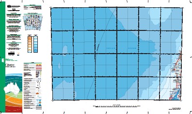
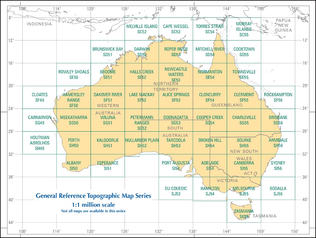
This map is part of a series which comprises 50 maps which covers the whole of Australia at a scale of 1:1 000 000 (1cm on a map represents 10km on the ground). Each standard map covers an area of 6 degrees longitude by 4 degrees latitude or about 590 kilometres east to west and about 440 kilometres from north to south. These maps depict natural and constructed features including transport infrastructure (roads, railway airports), hydrography, contours, hypsometric and bathymetric layers, localities and some administrative boundaries, making this a useful general reference map.
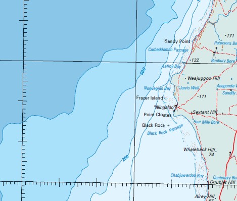
Cuvier Exmouth Cape Range Canyon Cape Range Escarpment Cape Range Fracture Zone Carnavon Canyon Cloates Canyon Cuvier Abyssal Plain Cuvier Basin Cuvier Plain Exmouth Plateau Exmouth Rise Exmouth Swell Montebello Saddle Montebello Trough Sonja Ridge Sonne Ridge Coral Bay 10 Mile Well 11 Mile Tank 16 Mile Tank 17 Mile Well 184 Well 3 Mile Tank 3 Mile Well 5 Mile Tank 6 Mile Well 7 Mile Tank 9 Mile Wells Airey Hill Airey Pool Alison Point Amherst Point Anaconda Well Anchor Hill Apex Hill Artesian Bore Ayliff Tank Ayliff Well Barrabiddy Creek Bateman Bay Beacon Point Big Bore Billabong Tank Bills Bay Black Rock Black Rock Passage Bolman Hill Booracoorilya Pool Boorawoora Pool Boundary Reef Brockmans Tank Brown Well Bruboodjoo Point Bulbarli Point Bulbarli Reef Bulbarli Well Bunbury Bore Bunbury Tank Camp Hill Cape Farquhar Cape Range Cape Range National Park Cape Range No. 2 Oil Well Carbaddaman Passage Cardabia Cardabia Passage Carlilywaroo Pool Carter Hill Cattle Tank Centenary Bore Central Hill Chabjuwardoo Bay Chingarri Well Cloates Hill Coast Hill Coral Bay Nursing Post Corbett Well Crayfish Reef Daly Hill Dawson Hill Doublet Hill Eighteen Mile Pool End Tank Entrance Hill False Hill Farnham Well Five Finger Reef Flemington Well Fletcher Hill Frazer Island French Hill Gnaraloo Gnargoo Pool Gnargoo Range Gnarraloo Bay Gooseneck Hill Greyling Hill Griffen Bore House Well Jane Bay Jarvis Well Javis Well Jurabi Point Kadjilikundi Well Kooloobelloo Well Lakeside Lefroy Bay Lilydale Tank Low Point Lund Hill Lyndon River MacLeod Madges Bore Manarrah Creek Mandu Mandu Mandu Mandu Bore Mandu Mandu Creek Mandu Mandu Gorge Mangrove Bay Mangrove Creek Marsh Hill Maud Hill Mauds Landing Mesa Milyering Milyering Well Minilya Minilya Pool Minilya River Monajee Cave Monck Head Monument Well Moonta Rock Mount Campbell Neds Ningaloo Ningaloo Marine Park Ningaloo Reef No. 1 Bore No. 2 Tank No. 4 Tank No. 6 Tank North Bore North Hill Norwegian Bay Old Gnaraloo Osprey Bay Oyster Stacks Paterson Bore Pearson Hill Pelican Point Perth Hill Pilgonaman Bay Pilgonaman Creek Pilgonaman Gorge Pilgonaman Well Pilgramunna Point Anderson Point Billie Point Cloates Point Cloates Light Point Cloates Lighthouse Point Edgar Point Maud Pommies Tank R.A.A.F. Canyon Range Well Round Headed Hill S.S. Perth Sandfly Bore Sandy Bay Sandy Bluff Sandy Point Scorpion Well Sextant Hill Shed Well Skeleton Beach Snake Gully Well South Hill South Passage South Yardie Well Stanley Hill Stanley Pool Steve Well Steves Well Stone Tank T Bone Bay Tantabiddi Tantabiddi Creek Tantabiddi Passage Tantabiddi Well The Bore Tulki Beach Tulki Gorge Tulki Well Turkey Hill Turquoise Bay Twin Hill Twin Tanks Unknown Hill Upper Bulbarli Well View Hill Wadera Bore Wally Tank Wally Well Warroora Warroora Well Weajuggoo Hill West End Tank Whaleback Hill White Ant Bore Wilson Well Winderabandi Point Yalobia Hill Yalobia Passage Yalobia Well Yardie Creek Yellow Hill Wilds Island Darwin Reefs Kudumurra Well Tantabiddy Well Noridear Millarrin Trealla Hill The Jacob Remessens Yardi Creek Bundera Bundera Well Bunderra Bunderra Well Bundera Bundera Wealjugoo Hill Weaguggu Hill Fraser Island Frazer Islet Crayfish Rock Bauboodjoo Point Maud Landing Yalobra Hill Waroora North Reef Gnarraloo Gnaraloo Homestead Moodoogooroo Pool Lake McLeod
| Name: | Cloates |
| Publisher: | Geoscience Australia (Australian Government) |
| Scale: | 1:1000000 |
| Latitude Range: | 20° 0.0′ S – 24° 00.0′ S |
| Longitude Range: | 108° 0.0′ E – 114° 0.0′ E |
| Projection / Datum: | Lambert Conformal Conic, GDA94 |
| Approx Print Size: | 0.44m X 0.67m |
| Publication Date: | 2013 |