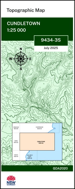

Cundletown 1-25,000 NSW Topographic Map 9434-3-S
$16.95
Description:
Cundletown 1-25,000 NSW Topographic Map 9434-3-S Print on Demand
Cundletown 1-25,000 Scale NSW Topographical Map is used for Walking, 4WD, Fishing, Camping, Motorcycle, both On and Off Road, Gold Prospecting and for those simply going for a family weekend drive.
Topographical maps show not only Contours of the Terrain but also Walking Tracks, Sealed and Unsealed Roads, Rivers, Creeks, Lakes, Historical Point of Interest, Old Mine Sites mbtg and National and State Park areas.
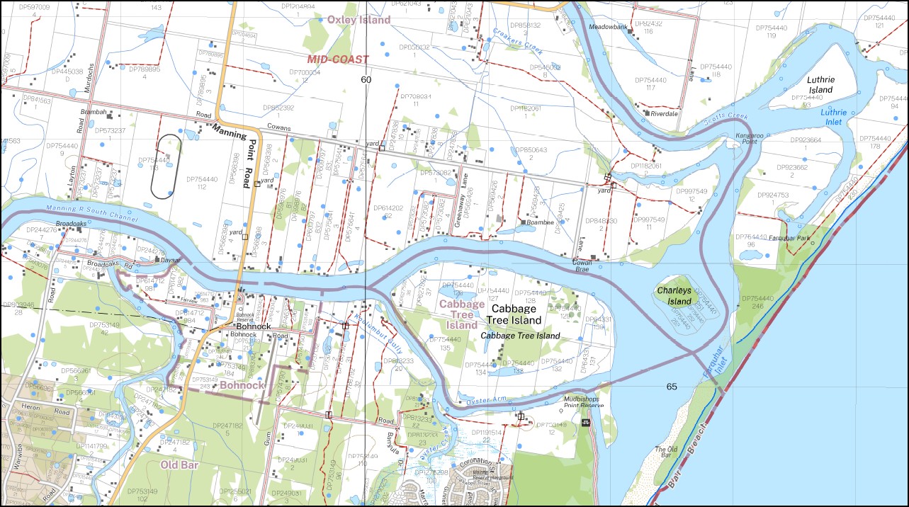
This map includes the following localities: Orange Grove Meadowbank Willow Grove Dernley Paringa Broadoaks Manning Point Old Bar Wallabi Point Berady Creek Blairs Creek Bohnock Brighton Brimbin Creek Bukkan Bukkan Creek Cabbage Tree Island Charleys Island Croakers Creek Cundletown Dawson River Farquhar Inlet Farquhar Park First Rock Gully Ghinni Ghinni Goat Island Harrington Inlet Carbeba Charlies Island Dawsons River First Rock Creek Gilmore Creek Khappinghat Creek Kiwarrak State Forest Koolumbut Gully Koorainghat Creek Lone Island Luthrie Bay Luthrie Inlet Luthrie Island Mangrove Creek Manning River South Channel Market Square Midgy Gharrat Island Midgy Creek Millers Creek Millers Swamp Mitchells Island Mitchells Island Cemetery Mudbishops Point Reserve Muddy Creek North Passage Old Bar Park The Old Bar Oxley Oxley Island Oxley Island Cemetery Oyster Arm Oyster Creek Oyster Reach Paddys Creek Pampoolah Pampoolah Reserve Pelican Bay Pelican Island Pelican Point Scotts Creek South Passage Stingray Creek Stingray Inlet Taree Airport Thelcuback Creek The Moor Tungheraba Victoria Square Warkawerook Varwiba Creek Warwiba River Duckhole Gully Dumaresq Island Duckhole Creek Bushland Park Albert Square Cundletown Public School Dennis Shoal Ghinni Ghinni Public School Kangaroo Island Kangaroo Point Kendall Reserve Old Bar Beach Racecourse Creek Race Course Gully Saltwater Point Saltwater Urana Bombora Sheather Creek Old Bar Pine
| Scale: | 1:25,000 |
| Latitude Range: | 31 52.5 S – 32 00.0 S |
| Longitude Range: | 152 30.0 E – 152 45.0 E |
| Approx Print Size: | 0.56m X 1.11m |
| Projection: | Transverse Mercator
GDA 2020 Edition 2025 |
You may also like…
-
Grants Head 1-25,000 NSW Topographic Map 9434-1-N
Price range: $16.95 through $28.95Select options This product has multiple variants. The options may be chosen on the product page -
Laurieton 1-25,000 NSW Topographic Map 9434-1-S
Price range: $16.95 through $28.95Select options This product has multiple variants. The options may be chosen on the product page -
Lorne 1-25,000 NSW Topographic Map 9434-4-S
Price range: $16.95 through $28.95Select options This product has multiple variants. The options may be chosen on the product page -
Taree 1-25,000 NSW Topographic Map 9334-2-S
Price range: $16.95 through $28.95Select options This product has multiple variants. The options may be chosen on the product page