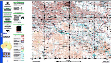
Henbury 1-250,000 Topographic Map GA
Price range: $15.95 through $27.95
Description:
Henbury 1-250,000 Topographic Map GA Print on Demand
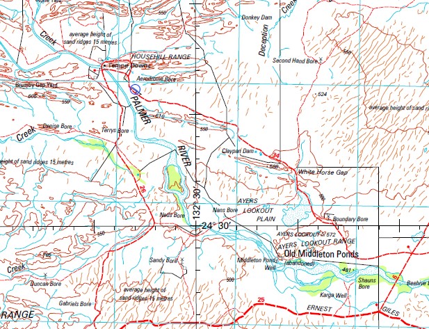
Areyonga Alalgara Yard Amphitheatre Ampire Waterhole Antiarra Waterhole Areyonga Airfield Areyonga Creek Areyonga Health Centre Areyonga School Arkanta Ayers Lookout Ayers Lookout Plain Bacon Range Black Cap Dam Bluehill Dam Boggy Hole Creek Boomerang No 4 Bore Boswell Bore Bowra Bore Bowson Waterhole Boxwood Dam Briscoe Pass Briscoe Tent Hill Britannia Waterhole Brumby Waterhole Bulldust Dam Canteen Waterhole castle Hill Cave Hole Mill Cave Hole Yard Chandlers Range Christopher Pinnacle Circle Gully Cockys Camp Yard Cottonbush Bore Crows Nest Bore Dead Bird Dam Dead Bullock Dam Deception Creek Dry Yard Dam Eight Mile Waterhole Eninta Creek Farrar Yard Ferrar Spring Fifteen Mile Creek Five Mile Creek Four Mile Bore Fox Dam Froud Creek Glen of Palms Gordon and Ida Abbott Park Government Bore Harts Camp Waterhole Haunted Tree Bore Henbury Henbury Aerodrome Henbury Meteorite Conservation Park Henbury Meteorite Craters Highway Bore Highway Dam Horse Camp Waterhole Horse Paddock Well Horse Plain Househill Range Illamurta Spring Illara Creek Illara North Creek Illara Rocks Illara Waterhole Illawilla Bore Illawilla Creek Illbilla Creek Illbilla Spring Dam Ilpurla Indera Bore Indera Dam Intjartnama Ipolera No 1 Bore James Range Bore James Ranges Karga Well Krichauff Ranges Lawrence Gorge Levi Penham Park Levi Range Liddle Hills Little Ampire Well Little Palm Creek Log Hole Creek Ltira Maldney Hill Maloney Bore Maloney Creek Maudacadatta Bore Mcclures Gap Mcclures Springs Mcguinnes Bore McMinn Creek Merrick Gully Meteorite Dam Middleton Ponds Middleton Ponds Well Mill Ridge Monument Waterhole Moonlight Gap Dam Mopoke Dam Mount Alfred Mount Caldwell Mount Hermannsburg Mount Hitchins Mount Holder Mount Keartland Mount Levi Mount Lewis Mount Merrick Mount Ormerod Mount Quin Mount Reginald Mount Shady Mt Quinn Bore Mt Sunday Dam Nallysnum Bore Napplebar Yard Natjitnama Nineteen Mile Creek Nineteen Mile Gully Norman Gully Old Station Old Station Well Orange Creek Palm Creek Palm Paddock Palm Valley Palm Valley Chalet Palmer River Palmer Valley Pantyinteme Pertarratenge Petermann Hills Phillip Creek Pituri Bore Red Sandhill Redbank Waterhole Redbank Yard Rockhole Bore Rogers Pass Salt Creek Bore Salt Creek Dam Salt Hole Seymour Range Shag Waterhole Snake Hole Southward Bore Stadium Bore Stephenson Dam Stock Hill Stone Yard Storm Creek Stuart Well Tempe Downs Tent Hill The Bluff Waterhole The Sisters The Twins Three Mile Dam Tidenvale Creek Titra Well Todd Glen Trickett Creek Turkey Bore Turner Bore Ukaka Ukaka School Undia Creek Undia Waterhole Valley Bore Valley Dam Victory Waterhole Walker Gorge Walker Plain Wallace Rockhole Wallace Rockhole Health Centre Wallace Rockhole School Wallera Ranch White Horse Gap Windy Dam XXXX Bore Yaua Bore Yaua Creek Owen Springs Owens Springs McMinn Spring McMinns Spring Ellerys Creek Waterhouse Range Krichauff Range Mount Parks The Mueller Muller Creek Laurences Gorge James Range Bowsons Waterhole Harris Gap Illara Rock Walker Creek McMinns Creek Doctors Stones Renners Rock Tricketts Creek Middletons Fish Ponds Middletons Ponds Peterman Creek Box Flat Christophers Pinnacle Bacons Range Wollara Well Old Angas Downs Peddles Ponds Angas Downs Angus Downs Liddle Hill Briscoes Pass Mount Quinn Seymours Range Kernot Range
| Name: | Henbury SG53-01 |
| Publisher: | Geoscience Australia (Australian Government) |
| Scale: | 1:250,000 |
| Latitude Range: | 24° 00.0′ S – 25° 0.0′ S |
| Longitude Range: | 132° 0.0′ E – 133° 30.0′ E |
| Projection / Datum: | Universal Transverse Mercator, GDA94 |
| Approx Print Size: | 0.44m X 0.67m |
| Publication Date: | 1-Jun-04 |