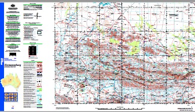
Hermannsburg 1-250,000 Topographic Map
$15.95 – $30.95
Description:
This 1-250,000 topographic map is part of the series that covers the whole of Australia at a scale of 1:250 000 (1cm on a map represents 2.5 km on the ground) and comprises 513 maps. This is the largest scale at which published topographic maps cover the entire continent. Each standard map covers an area of 1.5 degrees longitude by 1 degree latitude or about 150 kilometres from east to west and 110 kilometres from north to south. There are about 50 special maps in the series and these maps cover a non-standard area. Typically, where a map produced on standard sheet lines is largely ocean it is combined with its landward neighbour. These maps contain natural and constructed features including road and rail infrastructure, vegetation, hydrography, contours (interval 50m), localities and some administrative boundaries. The topographic map and data index shows coverage of the sheets. Product Specifications Coverage: The series covers the whole of Australia with 513 maps. Currency: Ranges from 1995 to 2009. 95 of maps have a reliability date of 1994 or later. Coordinates: Geographical and either AMG or MGA (post-1993) Datum: AGD66, GDA94, AHD. Projection: Universal Traverse Mercator (UTM) Medium: Paper, flat and folded copies.
Part of the Tanami Road Alice Springs to Halls Creek
Hermannsburg 16 Mile Dam 5 Mile Bore 5 Mile Gap 8 Mile Gap Ace Bore Adnoondo Waterhole Alice Valley Alkngarriintja Amburla Amburla Airstrip Amburla Creek Amburla Dam Andantoompantie Waterhole Angkerle Arrenge A Angkerle Arrenge B Argilkie Creek Armstrongs Arrkapa Arumbera Creek Audantoompantie Waterhole Bagot Creek Bagot Springs Blackhill Dam Bluegrass Bore Boggy Hole Bore Boomerang Bore Boundary Dam Breaden Creek Breaden Yard Brinkley Bluff Brumby Bore Bullocky Bore Burt Plain Cattle Creek Bore Ceilidh Hill Chain Of Ponds Yard Chalet Ridge Charley Bore Charley Creek Chewings Range Clarke Creek Clearhole Waterhole Crawford Creek Crossing Well Cumming Yard Currenjackie Bore Dashwood Creek Dashwood Crossing Bore Dashwood No 8 Bore Davenport Creek David Bore Derwent Desert Bore Devitt Hill East Creek East Waterhole Eastern Dam Eclipse Bore Edgar Springs Eight Mile Eight Mile Yard Elbulinger Bore Ellery Creek Ellery Creek Big Hole Ellery Creek Big Hole Nature Park Ellery Creek Yard Erajaca Dam Erajaka Well Ewarts Springs Exoil No 1 Oil Bore Fifteen Mile Yard Figtree Point Finke Gorge Finke Gorge National Park Fish Hole Fish Hole Yard Five Mile Frazer Hill Frews Yard Gilbert Creek Gilbert Spring Gilbert Springs Giles Spring Gill Pass Glen Helen Glen Helen Lodge Glen Ormiston Yard Gosse Dam Gosses Bluff Goyder Pass Gussys Well Haasts Bluff Halcombs Creek Halleem Creek Hamburger Dam Hamilton Bore Hamilton Creek Hamilton Downs Hanson Bluff Healing Heavitree Range Hermannsburg Aerodrome Hermannsburg Health Centre Hugh Gorge Ildirika Dam Ilkarralalama Ilyabba Dam Importna Injulkama Ipalala Ipolera Ipolera Dam Ipolera No 1 Bore Ipolera No 2 Bore Ipolera School Ironwood Bore Jerimah Creek Joker Bore Junction Bore Kaporilja Spring Kaporilya Karanji Bore Katapata Gap Katjutari Kulpitarra Kulpitharra Kutta Putta Kwala Labrapuntja Latz Dam Left Bower Bore Liltjera Limestone Bore Littles Yard Ljiltera Spring Long Hole Bore Look Down Yard Lower Mount Hermannsburg Luntharra Lyilyalanama MacDonnell Ranges Madderns Yard Mallee Bore Marshall Bore Max Bore Mbalkanaka Mbunghara Mbunghara School Mereeni Bore Mereenie Range Mereenie Valley Merral Ntarrakala Middle Dam Middle Waterhole Milton Park Missionaries Plain Missionary Plain Mitchell Bore Mothers Dam Motna’s Mount Chapple Mount Chapple Bore Mount Conway Mount Giles Mount Hay Mount Hay Bore Mount Hermannsburg Mount Heuglin Mount Katapata Mount Razorback Mount Sonder Mount Zeil Mulga Bore Namatjira Narwietooma Neil Hargraves Lookout New Bore No 1 Bore No 10 Bore No 15 Bore No 16 Bore No 18 Bore No 19 Bore No 2 Bore No 20 Bore No 21 Bore No 23 Bore No 25 Bore No 26 Bore No 28 Bore No 29 Bore No 3 Bore No 31 Bore No 32 Bore No 33 Bore No 34 Bore No 35 Bore No 36 Bore No 37 Bore No 38 Bore No 4 Bore No 40 Bore No 41 Bore No 42 Bore No 43 Bore No 6 Bore No 7 Bore No 9 Bore Ntakarra Ntaria Police Station Ntaria School Old Hamilton Downs Old Owen Springs Old Station Well Oolooroo Waterhole Oondoomoola Waterhole Ormiston Creek Ormiston Gorge Ormiston Pound Owen Springs Owen Well Paisley Bluff Pats Hole Dam Pile Hill Pine Point Pioneer Creek Point Helena Point Howard Poll And Diamond Dam Pridmore Bore Punya Dam Queens Bore Raggatts Well Rarangantjuta Redbank Creek Redbank Gorge Redbank Hill Reedy Hole Waterhole Right Bower Bore Robbies Bore Rockybar Creek Rodina Bore Rodina Waterhole Rodna Rudalls Creek Rutjingka Ryans Gap Ryans Gap Dam Sandscreen Bore Serpentine Chalet Serpentine Gorge Shulbunga Yard Sixteen Mile Creek Snake Bore Snake Hole Dam South Creek Spencer Gorge Spinifex Bore Spring Gap Bore Standley Chasm Stokes Pass Stokes Well Stuart Pass Sugar Creek Supplejack Dam Teapot Yard The Darwent The Derwent Thelma Bore Titra Well Tjamangkurra Tnawurta Tnyimipurta Town Bore Trucking Yard Turkey Bore Turn Off Bore Twin Bore Tylers No 1 Oil Bore Tylers Pass Ulpunda Umbarta Creek Undandita Undandita Claypan Undandita Creek Undurana 1C Undurana 2A Valley Bore Waterhouse Range Welcome Spring West MacDonnell National Park West Waterhole West Waterhouse Western Dam Yakala The Dashwood Derwent Creek Anburta Creek Mount Heughlin Six Mile Creek Sixteen Mile Dam Mount Ziel Adla Hill Redbank Old Redbank Ceildh Well Uldirika Dam Davenport River Glen Helen Tourist Camp Glen Helen Homestead The Ormiston Paisleys Bluff Brinkleys Bluff Macdonnell Ranges Jay Creek Strehlows Camp Gosses Bluff Range Gosse Range Rudall Creek Missionary Plains Milners Camp Hermannsburg Mission Bagot Spring Owens Springs
| Name: | Hermannsburg |
| Publisher: | Geoscience Australia (Australian Government) |
| Scale: | 1:250000 |
| Latitude Range: | 23° 00.0′ S – 24° 00.0′ S |
| Longitude Range: | 132° 0.0′ E – 133° 30.0′ E |
| Projection / Datum: | Universal Transverse Mercator, GDA94 |
| Approx Print Size: | 0.44m X 0.67m |
| Publication Date: | 1-Jun-04 |


