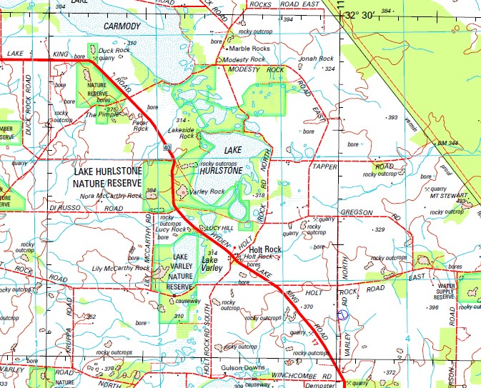
Hyden 1-250,000 Topographic Map
$15.95 – $30.95
Description:
Print on Demand
Locations within this Map
Varley Karlgarin Hyden Agnes Gully Allen Soak Altona Downs Anderson Rocks Bemrose Biglin Nature Reserve Bottle Rock Bounty Broom Gully Burngup Bushfire Rock Bushfire Rock Nature Reserve Camel Peaks Camm Farms Captain Roe Rock Chalk Hill Cockatoo Rock Coombrae Crooks Nature Reserve Cunningham Hill Curringutting Rock Dampling Spring Daymar Dempster Rock Desert Fringe Digger Rocks Dornock Dragon Rocks Dragon Rocks Nature Reserve Dryden Hills Duck Rock Eclipse Lake Emu Plains Emu Rock Flower Hill Forrestania Forrestania Aerodrome Forrestania Group Four Rocks Gibb Rock Goddard Soak Gorry Gross Graball Graham Rock Graham Rock Nature Reserve Greenwell Hill Gregmaun Farms Harris Nature Reserve Hatter Hill Hippos Yawn Hodgson Bin Holt Rock Hyden Golf Club Hyden North Hyden Pre-School Hyden Primary School Hyden Rock Illawarra Ino Hill Jackson Nature Reserve Jackson Rock Jam Patch Rock Jonah Rock Karlgarin Hill Karlgarin Nature Reserve Karlgarin Primary School Kerrigan Kerrigan Rock Kiadec King Rock King Rocks Kuender Kuender Nature Reserve Kyarran Lake Ace Nature Reserve Lake Austral Lake Biddy Lake Camm Lake Carmody Lake Cronin Lake Cronin Nature Reserve Lake Fox Lake Gounter Lake Gounter Nature Reserve Lake Gulson Lake Hurlstone Lake Hurlstone Nature Reserve Lake Kathleen Lake Liddelow Lake Liddelow Nature Reserve Lake Newton Lake O’Connor Lake Varley Lake Varley Nature Reserve Lakeside Lakeside Rock Langfield Larconda Valley Lily Mccarthy Rock Little Italy Lucy Hill Lucy Rock Lynch Hill Malleevallee Manna Gum Soak Marble Rocks Marble Rocks Nature Reserve Mccann Rock Mcglinn Nature Reserve Mettam Knob Middle Ironcap Midgi Soak Milo Range Minyaka Modesty Rock Mordetta Mordetta Nature Reserve Mount Gibbs Mount Holland Mount Holland Aerodrome Mount Mallet Mount Sheridan Mount Stewart Mount Vernon Mount Walker Mount Walker Golf Club Mount Walker Primary School Mulkas Cave Murray Rock Narembeen Native Rocks Nora Mccarthy Rock North Burngup North Ironcap North Karlgarin Nyonger Panorama Pederah Pederah Nature Reserve Peter Rock Pingaring Pingaring Golf Club Pingaring Nature Reserve Pingaring Spring Powder Puff Hill Purnta Rock Rock View Nature Reserve Roe Roe Nature Reserve Sandalwood Rocks Sandplain Knoll Sandplain Rocks Scrivener Rockhole Scrivener Rocks Scriveners Nature Reserve Sedgemore Sharonville Sheoak Hill Sheoak Rock Sibford South Ironcap South Kuender Nature Reserve Springfield Sugg Rock Swanara Tamma Hill The Basin The Humps The Pimple Timcobs Townsend Soak Toy Hill Tullamarine Twine Reserve Uno Hill Varley Country Club Varley Rock Warrawidgee Wattle Rocks Wave Rock Welcome Hill Welsh Nature Reserve West Holleton Wheeler Rock Woolocutty Woolocutty Soak Worland Hill Y Worrie Breakaways Sandalwood Rock Challenger Harbour Woolcutting Soak Camel Rocks Bald Rock Dreyden Hills Rock Hill Lake OConnor Lake OConner Marble Rock Ironstone Rocks Lake Hurlestone Lily McCarthy Rock Jackson Rocks South Lake Vasley Wardercarrin Soak Wardercarrin Goddards Soak
| Name: | Hyden |
| Publisher: | Geoscience Australia (Australian Government) |
| Scale: | 1:250000 |
| Latitude Range: | 32° 00.0′ S – 33° 00.0′ S |
| Longitude Range: | 118° 30.0′ E – 120° 0.0′ E |
| Projection / Datum: | Universal Transverse Mercator, GDA94 |
| Approx Print Size: | 0.44m X 0.67m |
| Publication Date: | 1-Jun-99 |


