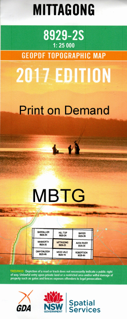
Mittagong 1-25,000 NSW Topographic Map
Price range: $16.95 through $31.95
Description:
8929-2-S Print on Demand
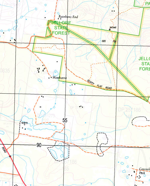
Colo Valley Farm Wombeyan Park Jellore The Crags Lynfield Kanangra Park Mandemar Bimbadgen Colo Vale Berrima Bowral Mittagong Willow Vale Aylmerton Aylmerton Public School Lake Alexandra Mount Alexandra Bendooley Hill Town of Berrima Berrima Public School Boardman Park Black Springs Creek Blacksprings Creek Bloomfield Borehole Creek Bore Hole Creek Bowens Creek Bowmans Creek Bowmans Hill Bowral High School Bowral Public School Bowral Railway Station Bowral Quarry Siding Braemar Braemar Railway Platform Braemar Railway Station Chinamans Creek Clear Hills Cockatoo Hill Colo Vale Railway Station Cordeaux Creek Cutaway Creek Cutaway Hill Foley Park Forty Foot Falls Gap Creek Gibbergunyah Gibbergunyah Creek Gibraltar Gibraltar Gap Mount Gibraltar Glebe Park Glen Lorne Hassall Hurdle Hurdle Ridge Iron Mines Creek Jackey Jackeys Creek Jamieson Hill Joadja Creek Kells Creek College Park Cordeauxs Creek Fitzroy The Gap Creek The Gap Gibraltar or Gibbergunyah Creek Greenhill Green Hill The Green Hills Hurdle Range The Hurdle Range Ironstone Creek Lower Mittagong Mcarthurs Crossing Makin Reserve Mandemar Creek Mandemar Ridge Mandemar Range Mandemar Flat Right Branch Mandemar Creek Mandemar Creek Left Branch Part Of Medway Medway Dam Village of Medway Mount Misery Mittagong Creek Mittagong Public School Mittagong Railway Station Mount Alexander Mount Gibralter Nattai Nattai Creek Ninety Acre Hill North Bowral Oldbury Creek One Tree Hill Oxley Hill Oxleys Hill Powells Gully Powells or Paul Creek Reedy Creek Retford Public School Round Hill Sheepwash Creek Sixty Foot Falls Slippery Rock Soapy Flat The Soapy Flat Spring Hill Springside Stephens Park Stony Creek Sugarloaf Rock The Black Springs Creek The Clear Hills The Gib The Head of Joadja Creek Wallaby Rocks The Wallaby Rocks Mount Waratah Wattle Wattle Hill Weeping Falls Welby Wingecarribee River Woolshed Creek Drapers Creek Burradoo Burradoo Park Burradoo Platform Burradoo Railway Station Alexandra Anglewood School Burradoo Truant School Gibbergunyah Reserve Woodlands East Bowral Chisholm Hill David Wood Sporting Fields Balaclava Renwick High Range Mittagong Shire Carrada Rivulet
| Name: | Mittagong |
| Publisher: | New South Wales Government |
| Scale: | 1:25000 |
| Latitude Range: | 34° 22.5′ S – 34° 30.0′ S |
| Longitude Range: | 150° 15.0′ E – 150° 30.0′ E |
| Datum: | GDA 94 |
| Approx Print Size: | 0.56m X 1.11m |