
Mt Disappointment Kinglake Ranges Map Rooftop
$10.95
Description:
Mt Disappointment Kinglake Ranges Map Rooftop Waterproof
Featuring Mount Disappointment Forest
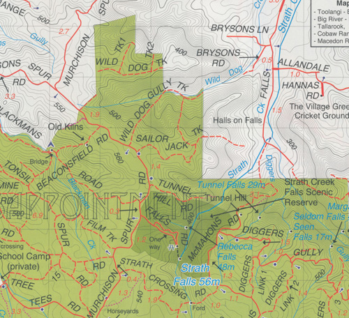
Coverage includes Reedy Creek, Wandong, Upper Plenty, Mount Disappointment, Hazeldene, Flowerdale, Strath Creek Falls, No.1 Camp, Blair’s Hut etc.
Facility symbols include Camping Areas, Picnic Areas, Lookouts and Fishing Spots.
The 1:50,000 scale map also includes, roads, vehicle, motorcycle and walking tracks, contours, elevations, and GPS co-ordinates with an inset of the Strath Creek falls area.
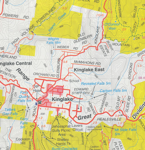
Also Featuring Kinglake National Park
Coverage includes Kinglake West, East & Central; Steels Creek, Strathewen, Pheasant Creek, Masons Falls, Mt Jerusalem, Mount Robertson, West Bridge, Wombelano.
Facility symbols include Camping Areas & Wineries.
The 1:50,000 scale map also includes, roads, vehicle, motorcycle and walking tracks, contours, elevations, and GPS co-ordinates.
New waterproof edition.
Additional product information
| Edition | Edition 3 |
| Publication date | 2015 |
| Map Scale | 1:50,000 scale |
| ISBN | 9781921886225 |
You may also like…
-
Yarra Glen 1-50,000 Vicmap
Price range: $12.00 through $24.00Select options This product has multiple variants. The options may be chosen on the product page -
Glenburn 1-50,000 Vicmap
Price range: $12.00 through $24.00Select options This product has multiple variants. The options may be chosen on the product page