

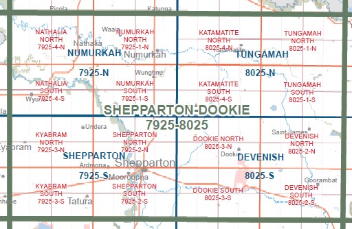
NATHALIA NORTH 1-25,000 Vicmap Topo Map 7925-4-N
Price range: $14.00 through $26.00
Description:
NATHALIA NORTH 1-25,000 Vicmap Topographic Map 79254N Now Print On Demand is used for Walking, 4WD, Fishing, Camping, Motorcycle, both On and Off Road, Gold Prospecting and for those simply going for a family weekend drive.
This is a new series of 1-25,000 scale maps, all of Victoria is now covered by these maps, including maps over the South Australian and NSW Borders.
Topographical maps show not only Contours of the Terrain but Walking Tracks, Sealed and Unsealed Roads, Rivers, Creeks, Lakes, Historical Points of Interest, Old Mine Sites, mbtg and National and State Park areas.
Main Features of this map includes:
Covers the old series Nathalia North 1-25,000 Vicmap
Nathalia, Barmah East, Numurkah Picola Rail Line BR, Nathalia NFR, part of River Murray Reserve, mbtg, part of Lower Goulburn National Park, Wakiti Creek SSR, part of Skelton Creek SSR, Wrights Bridge, Lower Moira, mbtg, MADOWLA PARK AIRFIELD, Elringtons Bridge, NARIOKA BR, James Bridge, Picola, NATHALIA NFR, SKELETON CREEK, Barwo
You may also like…
-
NUMURKAH NORTH 1-25,000 Vicmap Topo Map 7925-1-N
Price range: $14.00 through $26.00Select options This product has multiple variants. The options may be chosen on the product page -
Barmah Shepparton Deniliquin Adventure Map Haymans
Price range: $12.95 through $25.00Select options This product has multiple variants. The options may be chosen on the product page -
NATHALIA SOUTH 1-25,000 Vicmap Topo Map 7925-4-S
Price range: $14.00 through $26.00Select options This product has multiple variants. The options may be chosen on the product page -
NUMURKAH SOUTH 1-25,000 Vicmap Topo Map 7925-1-S
Price range: $14.00 through $26.00Select options This product has multiple variants. The options may be chosen on the product page -
Numurkah 1-50,000 Vicmap
Price range: $12.00 through $24.00Select options This product has multiple variants. The options may be chosen on the product page