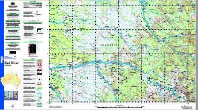
Red River 1-250,000 Topographic Map
$15.95 – $30.95
Description:
Print on Demand
Locations within this Map
Dagworth Abingdon Albemarle Albert Nyanza Lagoon Alldalla Ancaster Anglesey Aylesbury Aylesford Back Creek Barney Knob Barramundi Lagoon Barry Lagoon Battle Lagoon Berkeley Big Pelican Waterhole Big Sandy Creek Billycan Waterhole Birdwood Black Dog Creek Blackdown Blackfellow Waterhole Boomerang Lagoon Brodies Creek Buffalo Creek Bull Creek Bullock Creek Bydown Byerley Camp Creek Camp Oven Creek Campbell Creek Campbell Mountain Camperdown Cattle Creek Cawdor Cleanskin Creek Cobran Cope Crooked Creek Cumbana Dagworth Creek Daltons Lagoon Dance Creek Dandry Davis Lagoon Mount Departure Dickson Creek Mount Direction Dismal Creek Ducie Duckhole Dunmega Dwella Dynan Eaglehawk Creek Eden Vale Effingham Eight Mile Creek Eight Mile Waterhole Einasleigh Elizabeth Creek Mount Emu Enisse Lagoon Eresby Etheridge Etheridge River Fiery Creek Finch First Bull Run Creek Five Mile Creek Galloway Creek Goose Lagoon Goose Swamp Graces Creek Green Swamp Guttapercha Creek Harrowby Harry Lagoon Hertford Hill Lagoon Horse Lagoon Hotel Creek Iddesleigh Innes Insulator Creek Mount Jack Jacks Creek Jacks Lagoon Jampot Creek Jamtin Creek Jar Lagoon Kangaroo Creek Kara Knob Camp Kutchera Lancewood Creek Laragon Lees Lagoon Leggin Creek Leicester Leichhardt Creek Lily Lagoon Little Companion Creek Little Sandy Creek Lucy Lagoon Lygon Martin Creek Middle Creek Minnie Lagoon Minnies Mistake Creek Mooth Munbaverry Muthera Native Creek Nine Mile Creek Number Ten Creek One Mile Swamp Oswald Palmers Lagoon Parallel Creek Paulet Pelican Lagoon Pikes Creek Pinnacle Creek Point Ester Lagoons Police Creek Promise Creek Publican Creek Pudding Creek Puranga Randal Ravensworth Red Lagoon Red River Retreat Waterhole Ridge Lagoon Ripon Road Creek Roan Bull Waterhole Romney Rosie Lagoon Rowdier Lagoon Ryder Saddlecloth Creek Sandy Creek Saturday Creek Schneider Creek Scrubby Creek Sedan Creek Silent Creek Silky Oak Creek Six Mile Creek Soldiers Cap Sondes Spring Creek Stanhope Station Creek Strathmore Strathmore Lagoon Tate River Telegraph Waterhole Ten Mile Creek Thanyonce The Mill Ponds Three Horse Lagoon Three Mile Creek Tom McLean Waterhole Tomahawk Creek Tomahawk Swamp Torwood Torwood Creek Troopers Creek Tuckers Waterhole Turtle Creek Two Mile Creek Vesey Wallaroo Creek Waterloo Creek Watsons Waterhole Whistling Duck Waterhole Womblealla Woorgaman Yard Creek Yellow Biddy Lagoon Bulleringa National Park Strathmore Etheridge Shire Abingdon Downs Arbouin Bulleringa Strathmore Tablelands Regional Council The Lake The Lake Outstation Evergreen Piccanniny Outstation Retreat Dingo Springs Yard Rosie Lagoons Blackfellow Creek Mill Pond Lagoon Saddlecloth Yard Sixteen Mile Hut Middle Yard Holding Paddock Wearymans Rest Creek Palmers Yards New Bulleringa Soda Spring Brodies Camp Danes Creek Waterloo Holding Paddock Friendly Spring Camp Calloway Skull Yards Silkyoak Creek Dingo Spring Jam Tin Creek Jam Tim Creek Van Lee Pidgeon Spring Middle Lagoon Eden Vale Outstation Stumpy Lagoon Dismal Lagoon Angor Mount Campbell Myall Spring Clarkes Well Lancewood Soda Springs Little River Bells Waterhole Daniel Creek
| Name: | Red River |
| Publisher: | Geoscience Australia (Australian Government) |
| Scale: | 1:250000 |
| Latitude Range: | 17° 0.0′ S – 18° 00.0′ S |
| Longitude Range: | 142° 30.0′ E – 144° 0.0′ E |
| Projection / Datum: | Universal Transverse Mercator, GDA94 |
| Approx Print Size: | 0.44m X 0.67m |
| Publication Date: | 1-Jun-02 |


