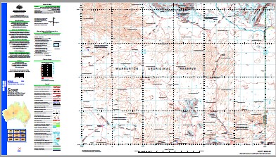
Scott 1-250,000 Topographic Map
$15.95 – $30.95
Description:
Print on Demand
Hidden Secret Waterhole Amy Giles Hill Amy Giles Rocks Arnold Creek Blackstone Community Butterfly Hill Caesar Hill Camel Bore Dean Range Edith Hull Springs Eliza Rocks Finlay Range Giles Aerodrome Giles Creek Giles Meteorological Station Glen Helen Hope Range Hubert Soak Jamieson Range Kathleen Range Kutjurntarl Rockhole Lehmann Hills Llurrpa Bore Mantamaru Community Match Hill Moorloru Bore Morgan Range Morgan Range A Bore Morraninna Hill Mount Daisy Bates Mount Deering Mount Elliott Mount Fanny Mount Finlayson Mount Gosse Mount Holt Mount Muir Mount Scott Murray Range Ngaanyatjarra-Giles Papulankutja Community Petermann Ranges Pine Tree Rocks Pirrul Bore Prostanthera Hill Tjulun Rockhole View Hill Walpa Pulka Bore Walu Community Walu Rockhole Walu Waterhole Walyina Bore Wannan Community Wannan Outstation Yungal Rockhole Yungalga Hill Pass of the Abencerrages The Giles Jameson Range Mount Elliot
| Name: | Scott |
| Publisher: | Geoscience Australia (Australian Government) |
| Scale: | 1:250000 |
| Latitude Range: | 25° 0.0′ S – 26° 0.0′ S |
| Longitude Range: | 127° 30.0′ E – 129° 0.0′ E |
| Projection / Datum: | Universal Transverse Mercator, GDA94 |
| Approx Print Size: | 0.44m X 0.67m |
| Publication Date: | 1-Jun-01 |


