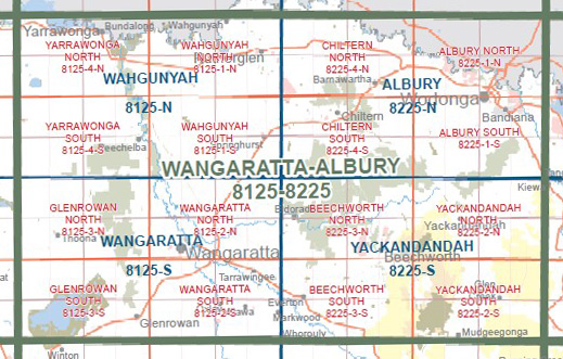
Wahgunyah 1-50,000 Vicmap
$12.00 – $24.00
Description:
Wahgunyah 1-50,000 scale Vicmap Topographical map 8125N is used for Walking, 4WD, Fishing, Camping, Motorcycle, both On and Off Road, Gold Prospecting and for those simply going for a family weekend drive.
Topographical maps show not only Contours of the Terrain but Walking Tracks, Sealed and Unsealed Roads, Rivers, Creeks, Lakes, Historical Points of Interest, Old Mine Sites mbtg and National and State Park areas.
Main Features of this map includes:
The Murray River from Yarrawonga to Corowa
Yarrawonga, Bundalong, Brimin, Rams Head, Lake Mulwala, River Murray Reserve, Williams Island, Lower Ovens WR, Parolas Bend Camping, mbtg, Naughtons South, Big Naughtons Camp, Boorhaman North, part of Warby-Ovens NP, Camerons Bend, Bundalong South, Mcquades Bend, Esmond, Dowdle Swamp, Boomahnoomoonah, Robinsons Track Camping Area, mbtg,Wilby, Peechelba, Boweya North, Almonds, Yeerip, Killawara, part of Warby-Ovens NP, Lavis Bend, part of Irishtown Creek, Killawara Forest Camp, mbtg, Spring Flower Walk, Warby Range, Mount Killawara, Killawara Reference Area (no public access)
Corowa, Wahgunyah, Rutherglen, Norong Central, Dugays Bridge, part of River Murray Reserve, Snake Island, Croppers Lagoon, Lumbys Bend, mbtg, Taylors Bend, Colclough Bend, Stantons Bend, Lake Moodemere, Liliput BR, Doma Mungi Creek SSR, Rutherglen NCR, mbtg, Springhurst, Norong, Rocky Waterholes Creek SSR, Peechelba East, Bontherambo BR, Black Swamp (Black Dog Creek NCR & WR), part of Warby – Ovens NP, mbtg, Boorhaman, Barambogie BR, Carrargarmungee BR, Peechelba-Wangaratta Rail Line BR, Wilson Bend Camping Area, Peartree Lane Camp, Killawarra, Hills Track Camp, Cod Point
You may also like…
-
YARRAWONGA NORTH 1-25,000 Vicmap Topographic Map 8125-4-N
$14.00 – $26.00Select options This product has multiple variants. The options may be chosen on the product page -
WAHGUNYAH SOUTH 1-25,000 Vicmap Topographic Map 8125-1-S
$14.00 – $26.00Select options This product has multiple variants. The options may be chosen on the product page -
Buraja 1-50,000 Vicmap
$12.00 – $24.00Select options This product has multiple variants. The options may be chosen on the product page -
WAHGUNYAH NORTH 1-25,000 Vicmap Topographic Map 8125-1-N
$14.00 – $26.00Select options This product has multiple variants. The options may be chosen on the product page -
Tungamah 1-50,000 Vicmap
$12.00 – $24.00Select options This product has multiple variants. The options may be chosen on the product page -
Fishing and Camping the Murray River AFN
Select options This product has multiple variants. The options may be chosen on the product page -
YARRAWONGA SOUTH 1-25,000 Vicmap Topographic Map 8125-4-S
$14.00 – $26.00Select options This product has multiple variants. The options may be chosen on the product page -
Wangaratta 1-50,000 Vicmap
$12.00 – $24.00Select options This product has multiple variants. The options may be chosen on the product page -
Mount Gwynne 1-50,000 Vicmap Topographical map 8026S
$12.00 – $24.00Select options This product has multiple variants. The options may be chosen on the product page -
Albury 1-50,000 Vicmap
$12.00 – $24.00Select options This product has multiple variants. The options may be chosen on the product page -
Howlong 1-50,000 Vicmap
$12.00 – $24.00Select options This product has multiple variants. The options may be chosen on the product page


