Alice Springs Oodnadatta Map Westprint
$15.95
5 in stock
Description:
Alice Springs Oodnadatta Map Westprint
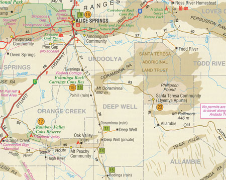
This Westprint Heritage Map has a map of the routes between Oodnadatta and Alice Springs on one side and is packed with all sorts of great information on the reverse side.
Coverage is from Oodnadatta and Marla in the south to Alice Springs, Glen Helen and Ross River HS in the north and includes the Old Ghan Route, Old Andado and the Stuart Highway.
A feature of all Westprint maps is the amount of text of historic and tourist interest. The map contains numbered symbols cross-referenced to detailed information on each numbered site. Intermediate and major distances are clearly shown and there are symbols for fuel locations, rest areas, caravan parks and camp sites. Early explorers routes have been colour-coded.
There are also GPS co-ordinates.
Scale: 1:1 Million Edition: 3rd
ISBN 978187560801