Broken Hill 1-250,000 Topographic Map
Price range: $15.95 through $30.95
Description:
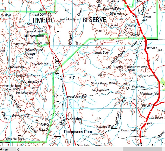
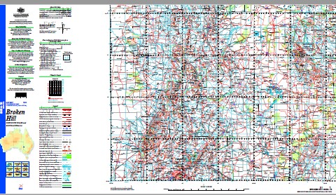
This 1-250,000 topographic map is part of the series that covers the whole of Australia at a scale of 1:250 000 (1cm on a map represents 2.5 km on the ground) and comprises 513 maps. This is the largest scale at which published topographic maps cover the entire continent. Each standard map covers an area of 1.5 degrees longitude by 1 degree latitude or about 150 kilometres from east to west and 110 kilometres from north to south. There are about 50 special maps in the series and these maps cover a non-standard area. Typically, where a map produced on standard sheet lines is largely ocean it is combined with its landward neighbour. These maps contain natural and constructed features including road and rail infrastructure, vegetation, hydrography, contours (interval 50m), localities and some administrative boundaries. The topographic map and data index shows coverage of the sheets. Product Specifications Coverage: The series covers the whole of Australia with 513 maps. Currency: Ranges from 1995 to 2009. 95 of maps have a reliability date of 1994 or later. Coordinates: Geographical and either AMG or MGA (post-1993) Datum: AGD66, GDA94, AHD. Projection: Universal Traverse Mercator (UTM) Medium: Paper, flat and folded copies.
Lynray Floods Creek Gnalta Fowlers Gap Research Station Mc Dougalls Well Rowena Ravendale Cymbric Vale Mount Woowoolahra Tirlta Mootwingee Yandaroo Gum Park Corona Sturts Meadows Old Rowena Kantappa Mulga Valley Bijerkerno Acacia Downs Langawirra Wilangee Boorungie Coogee Lake Waterbag Poolamacca Lintis Vale Paringa Mawarra Wendalpa Glenora Langidoon Koralta Mount Gipps Eldee Lake View Purnamoota Yalcowinna Hazel Vale Golden King abandoned Metford The Springs Glen Idol Nine Mile Melool Belmont ruins Bilpa Glen Lyon Mundi Mundi Acacia Vale K Tank Topar Broughton Vale Limestone Green Acres Rupee Mount Darling Peak Hill abandoned Donsandel Avondale Stirling Vale Clevedale Inkerman Byrnedale Broken Hill Silverton Albion Alberta Creek Gum Creek Acacia Siding Acacia Acacia Creek Barrier Ranges Big Aller Creek Big Bilpa Creek Bluff Blue Lake Black Hill Creek Mount Black Hill or Eurodo Blue Anchor Blue Anchor Tank Black Hill Bomangaldy Hill Brewery Creek Broken Hill Cemetery Broken Hill High School Broken Hill North Base Broken Hill Post Office Broken Hill Public School Broken Hill Railway Station Broken Hill South Base Broken Hill Sportsground Broken Hill Technical College Caloola Bluff Caloola Creek Campbells Creek Campbells Creek Bore Canegrass Swamp Cartwrights Creek Condah Creek Coonbaralba Range Corona Springs Cusin Creek Dead Finish Creek Democrat Creek Dense Camp Creek Depot Swamp Dering Mount Dering Eckerboon Lake Eldee Creek Mount Ellie Euriowie Euriowie Creek Euriowie Tank Evelyns Fairy Hill Floods Range Fowlers Gap Fowlers Gap Tank Mount Franks Gairdner Gairdners Creek Gairdners Tank Gap Glen Lyon Hills Gundara Waterhole Homestead Creek Imperial Lake Reserve Inkerman Lake Inkerman Swamp Ironblow Creek Joes Waterhole Jones Creek Jones Lake Kanandah Siding Kennedys Tank Kennys Hill Corona Creek Darling Creek Darling Range Fitzgeralds Creek Folly Creek Gum Creek Part Of Gum Creek Part of Wookookuroo Creek Joes Hole Joes Hole Creek Lakes Creek Lakes Grave Creek Lakes Knob Lakes Nob Langawirra Lake Lewis Peak Lewis Point Limestone Bore Lindsays Creek Little Aller Creek Little Bilpa Creek Little Star Creek Little Topar Little Topar Swamp Little Topar Tank Mount Lookout Lords Gorge Main Barrier Range Marachi Creek Midpoint Mindioomballa Creek Mindioomballa or Dry Creek Moorkaie Moorkaie Hill Moorkai Hill Mootwingee Historic Site Mootwingee Waterhole Morgan Street Public School Morphetts Creek Mount Darling Creek Mount Darling Range Mount Eltee Mt Gipps Railway Station Mount Pintapah or Euriowie Mount Wright Mount Wright Creek Mount Wright Tank Mulga Springs Mulga Springs Creek Mundi Mundi Creek Mount Mundi Mundi Mundi Mundi Plain Mundi Mundi Plains Mundi Mundi Range Murphys Lake Myalla Tank New Well Creek Nine Mile Creek The Nine Mile Creek Nootumbulla Creek North Barrier Nuchea Lake Number One Lake Oak Creek Old Mootwingee Creek Old Topar Swamp One Mile Creek One Tree Hill Paps Hills The Paps Para Creek Para Gully or Little Aller Creek Parnell Creek Picnic Creek Piesses Nob Piesses Knob Pine Lake Pine Swamp Mount Pintapah Poison Creek Polygonum Swamp Poolamacca Creek Poole Hills Pulpit Bluff Purnamoota Creek Village of Purnamoota Quarry Nob Queen Elizabeth Park Ramparts Ramparts Creek Ramparts Hills Rathole Rathole Creek Rathole Tank Rathol Razor Back Razorback Hill Red Hill The Red Hill Robe Mount Robe Robe Range Rock Hole Creek Rocky Creek Round Rowena Tank Ryans Creek Saladin Swamp Salt Hole Creek Sandy Gum Creek Scropes Scropes Range Scropes Range Creek Scropes Range Tank Shell Hill Silistria Lake Silver King Creek Silverton Cemetery Sinclairs Camp Sisters Hill The Sisters Slate Range Smiths Well Smiths Well Creek Soapstone Creek South Base Spring Creek Star Creek Stephen Stephens Creek Stephens Creek Reservoir Sundown Taltingan Tarltala Creek Tarrawingee Tarrawingee Springs Teamsters Creek Te Uro Creek The Bluff The Gorge Railway Station Three Mile Swamp Top Lake Treloar Creek Turtoopooroo Creek Mount Umberumberka Umberumberka Reservoir Umberumberka Storage Reservoir Umberumberka Umberumberka Creek Mount Vulcan Wallace Creek Waverly Creek Willa Willyong Creek Willowurrawa Creek Willyama Willyama High School Woodstock Lake Wookookaroo Creek Wookookuroo Creek Woolshed Creek Woolshed Tank Woolwash Creek Woowoolahra Worungil Yanco Glen Yancowinna Creek Yancowinnia Creek Vangulla or Big Aller Creek Burkes Cave Burke Ward Public School Byjerkerno Creek Byjerkerno Range Byjerkerno Ridge Byjerkerno Waterhole Byngnano Range Barrier School Silverlea School Bengoro Ridge J P Keenan Lookout Mundi Mundi Nature Reserve Corruga Flat Top Lewis Hill O’Neill Park Penrose Park Wills Street Infants School Morris’s Blow Alma Mootwingee National Park Alberta Badjerrigarn Bligh Byjerkerno Campbell Chamberlain Cook Coonbaralba Glenmore Harris Mulcatcha Sturt Tanyarto Yowahro Bengoro Bomgadah Byngnano Donnelly Forrest Fort Otway Maropinna Munye Nootumbulla Waverley Woodstock Woonunga Burke Burnayto Malta Nadbuck Patterson Bolaira Bomangaldy Bray Carrington Cathcart Jamieson Lewis Maharatta Matong Meadows Myalla Naradin Picton Tara Thackaringa Waukeroo Yancowinna East Yancowinna North Loftus Pampara Baroorangee Koonburra Eckerboon Wills Yancowinna Yangalla Torrowangee Follys Creek Follies Creek Folleys Creek Elti Scropes Range Bore Mutawintji Historic Site Mutawintji Waterhole Boco Teegarraara Mutawintji Cochra Well Linray Amphitheatre Creek Bengoro Range The Gap The Gap Out Station Nucha Lake Calcoola Creek McDougalls Well Bynguano Range Turtoopooroo Tirita Mount Woowoolahrah Cimbric Vale Kulka Saladin Lake Camels Hump Barrier Range Broken Hill Upland Broken Hill Uplands Main Dividing Range Stanley Range Barorangee Creek Willangee Coogee Daisy Lake Mount Robie Mount Gipps Out Station Mount Gipps Homestead Seventy Mile Plain Glenlyon Scoopes Ranges Scopes Ranges Peak Hill Broken Hill Municipality ONeill Park Mount Eurodo Wahratta Station
| Name: | Broken Hill |
| Publisher: | Geoscience Australia (Australian Government) |
| Scale: | 1:250000 |
| Latitude Range: | 31° 0.0′ S – 32° 00.0′ S |
| Longitude Range: | 141° 0.0′ E – 142° 30.0′ E |
| Projection / Datum: | Universal Transverse Mercator, GDA94 |
| Approx Print Size: | 0.44m X 0.67m |
| Publication Date: | 1-Jun-02 |