

Buller Howitt Alpine Area Map Spatial Vision FLAT
$16.95 – $28.95
Description:
Single Sided Map Only FLAT No Text
2 Sided map also available Print on Demand, see link below
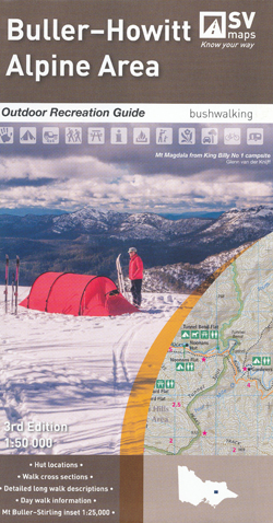
The Buller-Howitt Alpine Area recreation guide has visitor information regarding overnight hiking, walking tracks, major activities, car and four wheel touring as well as flora and fauna.
Special Features include:
Mt Buller Resort Mt Stirling Mt Howitt The Vikings Howitt Plain Bryces Plain The Bluff The Razorback Mt Magdala King Billy 1&2 Cobbler Plain Pineapple Flat Mt Buggery Howqua Hills Crosscut Saw Sheepyard Flat, Mt Speculation, Mt Despair
- Colour topographic map at 1:50,000 scale
- Overnight hiking routes and campsites
- Selected walking track cross sections indicating slope and difficulty
- Major recreational facilities, huts, parks and forests
- GPS co-ordinates of campsites and huts
- Historical information and photographs
SCALE: 1:50,000
COVERAGE: Mt Buller, Mt Stirling, Mt Howitt, Wonnangatta Station Sheepyard Flat
IDEAL FOR: Bushwalking, Cross-country skiing, mountain biking and car touring
EDITION: 1
SIZE (unfolded): 1000mm wide by 675mm high
ISBN9780648337621
Read More