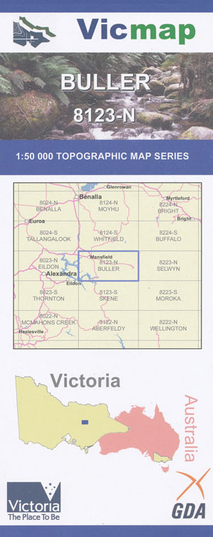
Buller 1-50,000 Vicmap
Price range: $12.00 through $24.00
Description:
Buller 1-50,000 scale Vicmap Topographical map 8123N is used for Walking, 4WD, Fishing, Camping, Motorcycle, both On and Off Road, Gold Prospecting and for those simply going for a family weekend drive.
Topographical maps show not only Contours of the Terrain but Walking Tracks, Sealed and Unsealed Roads, Rivers, Creeks, Lakes, Historical Point of Interest, Old Mine Sites mbtg and National and State Park areas.
Main Features of this map includes:
Eastern Section of Eildon and Eildon National Park
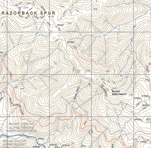
Mount Buller, Mt Buller Alpine Village , The Bluff, Howqua Gap, Howqua Hills, Howqua River, Mount Stirling, The Governors Remote and Natural Area, Eagle Peaks, Eight Mile Flat, Seven Mile Flat, Little Mount Buller, Tabacco Flat, mbtg, Lickhole Creek, Mount Timbertop, Fry Flat, Tunnel Bends, Frys Hut, mbtg, Merrijg, Saw Mill Settlement, mbtg, Part of the Razorback Spur, Bald Hill, Pilgrims Airstrip, Tomohawk Gap, Burnt Hut Knob, Mount Number 3, Mount Russell The Pinnacle, Pineapple Flat Camping Area, Charlie Rock, Mount Winstanley, Edge of Mount Stirling, King Saddle
Mansfield, Blue Range, Mount Battery, Mansfield Airport, Mahony Bridge, Chapple Hill, mbtg, Goughs Bay, Howqua, Howqua Hills, Parts of Lake Eildon, Macs Cove, Martin Gap, Brack Bridge, Howqua River, Delatite, Barwite
ISBN 9781742084336
You may also like…
-
BULLER SOUTH 1-25,000 Vicmap Topo Map 8123-1-S
Price range: $14.00 through $26.00Select options This product has multiple variants. The options may be chosen on the product page -
Selwyn 1-50,000 Vicmap
Price range: $12.00 through $24.00Select options This product has multiple variants. The options may be chosen on the product page -
Buffalo 1-50,000 Vicmap
Price range: $12.00 through $24.00Select options This product has multiple variants. The options may be chosen on the product page -
MANSFIELD SOUTH 1-25,000 Vicmap Topo Map 8123-4-S
Price range: $14.00 through $26.00Select options This product has multiple variants. The options may be chosen on the product page -
Eildon 1-50,000 Vicmap
Price range: $12.00 through $24.00Select options This product has multiple variants. The options may be chosen on the product page -
Buller North 1-25,000 Vicmap Topographic Map 8123-1-N
Price range: $14.00 through $26.00Select options This product has multiple variants. The options may be chosen on the product page -
Mansfield Mt Howitt Map Rooftop
Price range: $8.95 through $17.00Select options This product has multiple variants. The options may be chosen on the product page -
Buller Howitt Alpine Area Map Spatial Vision
Price range: $19.95 through $29.95Select options This product has multiple variants. The options may be chosen on the product page -
Moroka 1-50,000 Vicmap
Price range: $12.00 through $24.00Select options This product has multiple variants. The options may be chosen on the product page -
Whitfield 1-50,000 Vicmap
Price range: $12.00 through $24.00Select options This product has multiple variants. The options may be chosen on the product page -
Thornton 1-50,000 Vicmap
Price range: $12.00 through $24.00Select options This product has multiple variants. The options may be chosen on the product page -
MANSFIELD NORTH 1-25,000 Vicmap Topo Map 8123-4-N
Price range: $14.00 through $26.00Select options This product has multiple variants. The options may be chosen on the product page -
Skene 1-50,000 Vicmap
Price range: $12.00 through $24.00Select options This product has multiple variants. The options may be chosen on the product page