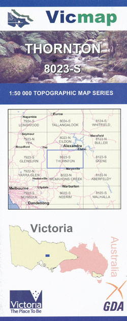
Thornton 1-50,000 Vicmap
Price range: $12.00 through $24.00
Description:
Thornton 1-50,000 scale Vicmap Topographical map 8023S is used for Walking, 4WD, Fishing, Camping, Motorcycle, both On and Off Road, Gold Prospecting and for those simply going for a family weekend drive.
Topographical maps show not only Contours of the Terrain but Walking Tracks, Sealed and Unsealed Roads, Rivers, Creeks, Lakes, Historical Points of Interest, Old Mine Sites mbtg and National and State Park areas.
Main Features of this map includes:
Buxton, Thornton, Taggerty, Acheron, Rubicon towns
The Bicentennial Trail Track from Keppel Falls to Athur Range near Torbreck Station
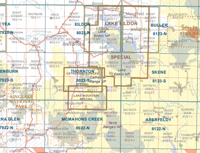
Cathedral Range State Park
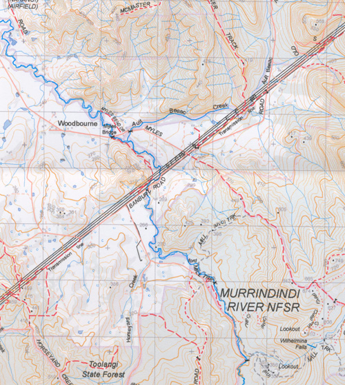
Murrindini River and Reserve and town, Mount Torbreck
Part of the Black Range State Forest and Toolangi State Forest
Horseyard Range, Edge of the Devils Staircase, Rock Mouth Spur. Break o Day Range, Spion Kopje, Glendale Plantation, Snobs Creek, Rubicon State Forest, Parts of the Marysville State Forest, Cerberean Range, Ghost Point, Mount Bullfight, Federation Range, Royston Gap, Second Creek Range, the bottom of Lake Eildon, Hargrave Spur
Thornton, Rubicon, Mount Torbreck, Goulburn River, Walker Hill, pert of the Rubicon State Forest, Andrews Spur, C E R B E R E A N R A N G E S, Christie Hill, Robb Hill, Snobs Creek, Wightman Hill, Snobs Creek Falls, Banyarmbite Cascades, Morriss Lookout, Kendals Camping Area, Royston Range, Rubicon Falls, Lower Royston Cascades, Hobin Gap (Pound Gap), Torbreck Range, MOUNT TORBRECK NFSR, Blue Gum Saddle, Dry Creek Hill, mbtg, Dry Creek Gap, Barkers Ridge, Barkers Gully Falls, southern section of Lake Eildon, Jerusalem Inlet, Wilson Inlet, Knowles Gap, White Cow Gap, Conn Hill, Cabbage Tree Gap, Otoole Flat Camping Area, The Pinnacle, Rocky Spur, Pinnacle Walking Track, Wombat Spur
Western part of the Cathedral Ranges, including TEN FATHOM RIDGE, Knobbys Spur, Neds Gully, Blackwood Flat, mbtg, The Gorge Falls, mbtg, South Eastern part of the Cathedral Ranges including The Gorge, Cooks Mill Camping Area, Lower Little River Cascades, Little River Cascades, Worrun Gorge Falls, Buttress Pinnacles, Mount Sugarloaf Paek and Mount Sugarloaf Saddle, The Green Hill, Ghost Point, Gumbadik Falls, Marysville View Lookout, edge of Marysville, Keppel Ridge, Keppel Walking Track, Whitehorse Saddle, Mount Margaret, Lady Talbot Drive, Tweed Spur, CERBEREAN RANGES, Rubicon Dam, Royston Dam, Rubicon Valley Historia Region, Long Heath, Triangle Junction, J U B I L E E R I D G E, Royston Gap, Mount Bullfight, DEAD TIMBER HILL, MBTG, Stillmans Lookout, ROYSTON RANGE, Torbreck Range, Snobs Gap, WINCH HILL, COLD WEATHER RANGE, Cold Weather Hill, Dudley Saddle, Hargrave Spur, Second Creek Range, Stocco Junction, Arthurs Range, Bull Range, Gum Top Ridge
Taggerty, Limestone, Spion Kopje, Humpback Bridge, Murrindindi, Woodbourne, McMasters Track, Black Range State Forest, Scrubby Creek Falls, Quinns Junction, Acheron, the edge of the Cathedral Range State Park including The Cathedral, Cathedral North, Little Cathedral, Neds Gully, Neds Peak, Neds Saddle The Gorge Falls, Dhadhadhong Falls, mbtg, Buxton, Buxton Peak, Taggerty State Forest, Break O Day Range, The Bald Hills, Sheehans Hills, MOUNT KLONDYKE, Devils Staircase, Xylophone Bridge, Murrindindi Cascades, Murrindindi Middle Cascades, Murrindindi Lower Cascades, Trafford Historic Mill Site, Upper Camp Creek Slide, Camp Creek Cascades, Murrindindi River, Mount Despair, MURRINDINDI RIVER NFSR, Wilhelmina Falls, Wilhelmina Falls Track, Mount Mitchell, Yea Rock, Glendale Plantation, Acheron Ridge, Granite Range
ISBN 9781742085920
You may also like…
-
Buller 1-50,000 Vicmap
Price range: $12.00 through $24.00Select options This product has multiple variants. The options may be chosen on the product page -
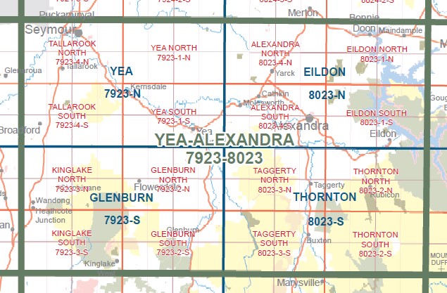
YEA ALEXANDRA 1-100,000 Vicmap Topo 7923-8023
Price range: $14.00 through $26.00Select options This product has multiple variants. The options may be chosen on the product page -
Glenburn 1-50,000 Vicmap
Price range: $12.00 through $24.00Select options This product has multiple variants. The options may be chosen on the product page -
TAGGERTY SOUTH 1-25,000 Vicmap Topo Map 8023-3-S
Price range: $14.00 through $26.00Select options This product has multiple variants. The options may be chosen on the product page -
THORNTON NORTH 1-25,000 Vicmap Topo Map 8023-2-N
Price range: $14.00 through $26.00Select options This product has multiple variants. The options may be chosen on the product page -
McMahons Creek 1-50,000 Vicmap
Price range: $12.00 through $26.00Select options This product has multiple variants. The options may be chosen on the product page -
Lake Mountain Marysville Special 1-25000 Vicmap
Price range: $14.00 through $26.00Select options This product has multiple variants. The options may be chosen on the product page -
Eildon 1-50,000 Vicmap
Price range: $12.00 through $24.00Select options This product has multiple variants. The options may be chosen on the product page -
Skene 1-50,000 Vicmap
Price range: $12.00 through $24.00Select options This product has multiple variants. The options may be chosen on the product page -
TAGGERTY NORTH 1-25,000 Vicmap Topo Map 8023-3-N
Price range: $14.00 through $26.00Select options This product has multiple variants. The options may be chosen on the product page -
Yea 1-50,000 Vicmap
Price range: $12.00 through $24.00Select options This product has multiple variants. The options may be chosen on the product page -
Yarra Glen 1-50,000 Vicmap
Price range: $12.00 through $24.00Select options This product has multiple variants. The options may be chosen on the product page -
Aberfeldy 1-50,000 Vicmap
Price range: $12.00 through $24.00Select options This product has multiple variants. The options may be chosen on the product page -
THORNTON SOUTH 1-25,000 Vicmap Topo Map 8023-2-S
Price range: $14.00 through $26.00Select options This product has multiple variants. The options may be chosen on the product page