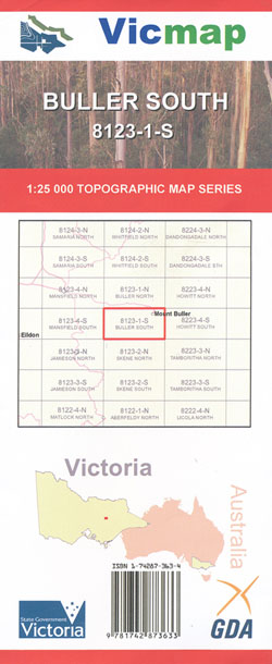
BULLER SOUTH 1-25,000 Vicmap Topo Map 8123-1-S
Price range: $14.00 through $26.00
Description:
Buller South 1-25,000 Topographic map Vicmap 81231S
Part of the Australian Alpine Walking Track
Mount Buller, The Bluff, Howqua Gap, Howqua Hills, Howqua River, Mount Stirling, The Governors Remote and Natural Area, Eagle Peaks, Eight Mile Flat, Seven Mile Flat, Little Mount Buller, Tabacco Flat, mbtg, Lickhole Creek, Mount Timbertop, Fry Flat, Tunnel Bends, Frys Hut
Read More
You may also like…
-
Buller Howitt Alpine Area Map Spatial Vision
Price range: $19.95 through $29.95Select options This product has multiple variants. The options may be chosen on the product page -
Buller North 1-25,000 Vicmap Topographic Map 8123-1-N
Price range: $14.00 through $26.00Select options This product has multiple variants. The options may be chosen on the product page -
Buller 1-50,000 Vicmap
Price range: $12.00 through $24.00Select options This product has multiple variants. The options may be chosen on the product page