
Frenchmans Cap Walk Map Tasmap
Price range: $8.95 through $18.95
Description:
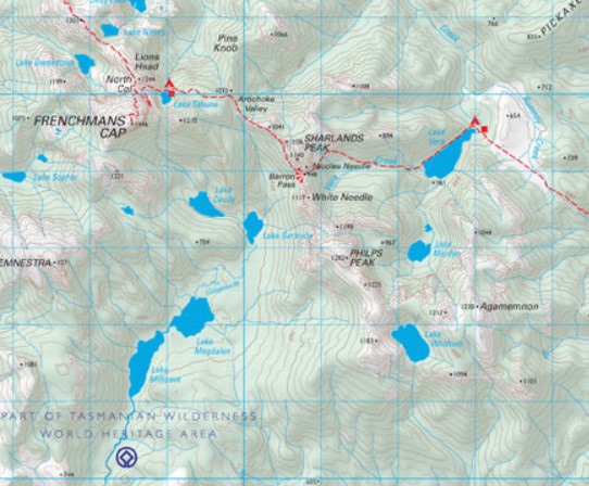
The magnificent quartzite dome of Frenchmans Cap (1443m) is a mecca for bushwalkers and climbers. The panoramic view from the peak on a clear day includes Mt Ossa, features of the southern end of Cradle Mountain – Lake St Clair National Park and Macquarie Harbour to the west.
This map highlights the walking tracks and features tourist information along with general topographic detail. The notes on the reverse side introduce visitors to the vegetation, land forms, animals, history of the area, bushwalking tips and safety essentials.
Reprinted with minor amendments in 2007.
| Production Year: | 2025 |
Datum:Australian Geodetic Datum 2020
Scale:1:50 000
ISBN: 9318923008296
Read More
You may also like…
-
Hartz Mountains National Park Map Tasmap
Price range: $12.95 through $24.95Select options This product has multiple variants. The options may be chosen on the product page -
Walls of Jerusalem National Park Map Tasmap
Price range: $14.95 through $26.95Select options This product has multiple variants. The options may be chosen on the product page -
Lake St Clair Day Walks Map Tasmap
Price range: $8.95 through $18.95Select options This product has multiple variants. The options may be chosen on the product page -
Bruny Island Walks Map Tasmap
Price range: $13.95 through $25.95Select options This product has multiple variants. The options may be chosen on the product page -
Highland Lakes Map and Angling Notes Tasmap
Price range: $13.95 through $24.95Select options This product has multiple variants. The options may be chosen on the product page