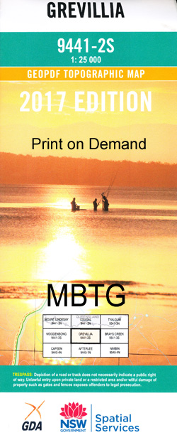
Grevillia 1-25,000 NSW Topographic Map
Price range: $16.95 through $31.95
Description:
Locations within this Map
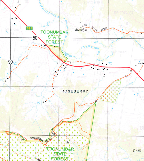
Avalon Glen Erin Glenarvon Treberth Unumgar The Gorge The Billabong Kildare Riverview Calamia Pinewood Gilgal Rosevilla Figtree Brooklyn Lionview Mount Lion Range View Rosedale Dowan Hill Orsova The Willows Avonleigh The Gap Carribee The Meadows Camberra Creek The Cape Railway Station Cedar Getters Creek Cougal Dennis Scrub Creek Ferndale Creek Findon Findon Creek Mount Glennie Gorge Creek Gradys Creek Grevillia Grevillia Gorge Mount Grevillia Grevillia Public School Gullyvul Peak Gullyvul Spring Hoppindick Creek Hungry Gully Mount Ida Imesons Johnstons Gully Findon Creek Public School Fords Creek Grevillias Mill Horseshoe Spur Imerson Imersons Kurrajong Creek Lemon Creek Lindesay View Lindsay View Lion Lion Mount Little O’Donnel Creek Loadstone Loadstone Public School Loadstone Railway Station Long Creek Middle Mount Mount Lion Public School Mount Lion Railway Station Murray Scrub Flora Reserve North Branch North Peak Oakey Creek Oaky Creek Old Grevillia Palm Gully Razorback Saddle The Razorback Richmond River The Risk Railway Station Roseberry Roseberry Creek Rukenvale Rukenvale Public School Sherwood Tayling Creek Terrace Creek The Risk The Risk Public School Toonumbar National Forest Waterhole Creek Dourrigans Gap Bundgeam Bundgeam Public School Moore Park Nature Reserve Roseberry State Forest Lynchs Creek Sheepstation Creek Loadstone Station Brindle Creek Mount Lion Station Warrazambil Creek The Cape Collins Creek
| Scale: | 1:25000 |
| Latitude Range: | 28° 22.5′ S – 28° 30.0′ S |
| Longitude Range: | 152° 45.0′ E – 153° 0.0′ E |
| Datum: | GDA 94 |
| Approx Print Size: | 0.56m X 1.11m |
Print on Demand