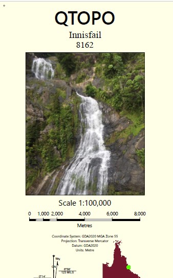
Innisfail 1-100,000 Topographic Map
Price range: $15.95 through $30.95
Description:
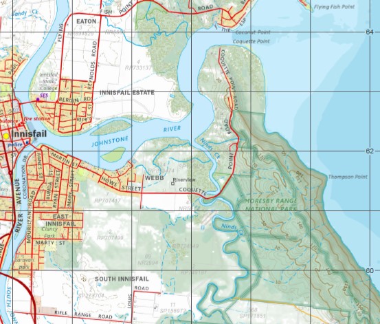
Locations within this Map
Riverview Granadilla Bingil Bay El Arish Innisfail Kurrimine Mission Beach Mourilyan Silkwood Wangan Wongaling Beach Moresby Mundoo Old Silkwood Adelaide Reef Armit Creek Bamboo Creek Banana Island Barley Creek Barneys Point Basilisk Range Beaver Reef Bay Hill Berryman Creek Bicton Creek Bicton Hill Big Maria Creek Boltons Saddle Boobah Creek Boobah Creek South Branch Boundary Creek Bovril Creek Bradshaw Island Brammo Bay Bresnahan Island Brown Range Buckleys Creek Bunting Creek Camp Point Carmoo Creek Cedar Creek Cheeki Creek Clump Mountain Clump Point Coconut Bay Coconut Point Condoi Creek Mount Coom Coo-Nana Coquette Point Cowley Beach Cowley Creek Cowley Creek South Branch Dargin Creek Daru Creek Digger Creek Double Barrel Creek Double Mountain Double Point Mount Douglas Dunk Island Dunkalli Eddy Reef Mount Edna Eel Creek Ellison Reef Ercegs Creek Esmeralda Hill Ethel Hill Etty Bay Feather Reef Fenbys Gap Flying Fish Point Framtons Gully Garners Beach Georgie Hill Geranium Passage Gill-Gill Mountain Glady Inlet Goodman Point Goondi Goor-Tchur Creek Goudge Bank Granadilla Creek Granadilla Ridge Hall Point Hall Rock Hall-Thompson Reef Hayter Point Hilda Hill Hull Hull Gap Hull Heads Hull River Humbug Reach Hutchison Island Innisfail Harbour Inno-Noo-Bah Jessie Island Johnstone River Junction Creek Jurs Creek Jurs Gap Kar-Tee Kaygaroo Creek Kennedy Bay Kenning Creek Kent Island King Reefs Koo-Lal-Bee Koo-Tal-Oo Mountain Kumboola Island Kurrimine Beach Kut-Tay Mountain Kyboola Creek Lacey Creek Lagoon Creek Mount Leeper Lily Island Limbo Creek Lindquist Island Little Moresby Creek Liverpool Creek Lockyer Creek Log Bridge Creek Luff Hill Lugger Bay Maizie Island Maria Creek Mar-Tel-Kee Martin Creek McCabes Gap Meaburn Rock Meera Midgeree Bar Creek Miks Gully Mission Hill Mistake Creek Moor-In-Jin Moresby Range Moresby River Mourilyan Creek Mourilyan Harbour Muff Creek Muggy-Muggy Mung Um Gnackum Island Murdering Point Mount Myrtle Ninds Creek Ninds Creek West Branch Ninney Point North Bamboo Creek North Barnard Islands North Hull River North Maria Creek Number One Creek Number Two Creek O’Donnell Creek Olive Rocks One Mile Creek Oom-Balla Pall-Koo-Loo Point Pallon Beach Panjoo Perry Rock Pil-Cal Poie-Koo-Kee Polka Corner Quatia Ramleh Robinsons Beach Rocky Point Saltwater Creek Sandy Creek Scheu Creek Shaws Corner Sisters Islands Snake Creek South Bamboo Creek South Barnard Islands South Johnstone River South Maria Creek South Mission Beach Spiers Rock Stagnant Creek Stephens Island Stewart Creek Stingaree Reefs Stockyard Creek Stony Creek Sugarcane Creek Surprise Shoal Swampy Creek Tah-Loo Mountain Tam O’Shanter Point Tam O’Shanter Range Mount Tam O’Shanter Tambal-Tambal Tams Creek Tapp-Ana Tawalla Creek Tchu-Goo-Berri-Me Point Teatree Gap Thompson Point Thorpe Island Tippett Creek Mount Tippett Toogan-Toogan Tool-Guy-Ah Creek Walter Creek Wambyan Warragon Beach Warrubullen Webb Creek Wildsoets Gap Wolngarin Island Wongaling Creek Wylies Creek Zahra Creek Bulguru Swamp Barnard Island Group National Park Carello Palm Swamp Conservation Park Etty Bay Road Conservation Park Family Islands National Park Hull River National Park Kurrimine Beach Conservation Park Kurrimine Beach National Park Maria Creek National Park Moresby Range National Park Warrina Conservation Park Mount Julia Moresby Range Resources Reserve Mount Archer Resources Reserve Mound Island Clump Mountain National Park Tam O’Shanter Forest Reserve Tam O’Shanter National Park Ambah-Ambah Barcoo Creek Bee-Ran Bidgeroo Boo-Garoo Bul-Loo-Go Creek Coobin-Cotan-You Cum-Mai-Nubble-Nubble Creek Gin-Gee Har-Ran Ika-Ika Karra-Malla Karra-Man Kee-Woo Kit-Ah Kum-Moo-Arra Mood-Goo-Gar Moo-Jee Creek Murgon Neyring Poola-Djoon Pool-Bee-Ee Tak-Al Tar-Koo-Kee Tarn-Coo-Rah-Ee Mountain Tee-Ree Tiering Keep-In-Ma Toora-Coorang Toorgey-Toorgey Creek Wallon-Boo Woor-Amboo Creek Carmoo Daveson Djiru Dunk Friday Pocket Boogan Coconuts Comoon Loop Cowley Cullinane East Innisfail Eaton Goolboo Goondi Bend Goondi Hill Innisfail Estate Lower Cowley Lower Tully Maria Creeks Martyville McCutcheon Midgeree Bar Mighell New Harbourline No. 5 Branch Sandy Pocket South Innisfail Stockton Tam O’Shanter Webb Victory Creek Nind Creek Mind Creek North Johnstone River North Branch Johnstone River Gladys Inlet Geraldton Johnstone River South Branch Mundoc Mount Leiper Hall Thompson Reef South Johnstone Niggerhead Goodman Rock Hayten Point Heyter Point Inarlinga Warrbullen Mountain Brown Sisters Island Sisters Islet Jaffa King Reef Double Hill Maadi Fenby Gap Tam OShanter National Park Mount Tam OShanter Mount Carron Mound Islet Purtaboi Island Mount Doulas Pedalion Point Toogan Toogan Point Pall Koo Loo Point Mung-um-gnackum Island Tam OShanter Point Timana Island
| Name: | 8162 |
| Publisher: | Queensland Government |
| Scale: | 1:100000 |
| Latitude Range: | 17° 30.0′ S – 18° 00.0′ S |
| Longitude Range: | 146° 0.0′ E – 146° 30.0′ E |
| Projection / Datum: | Universal Transverse Mercator, GDA 94 |
| Approx Print Size: | 0.56m X 0.56m |