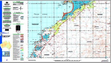
Lagrange 1-250,000 Topographic Map
$15.95 – $30.95
Description:
Print on Demand
Bidyadanga Community Admiral Bay Alex Well Ambrookah Well Balladonga Well Bamboo Landing Bannamah Well Barn Hill Barn Hill Outstation Beacon Hill Bethwyn Rise Microwave Repeater Station Billabong Dam Bittern Rock Black Rocks Blackrock Point Bloodwood Bore Boat Reef Brians Bore Brunbrunganjal Community Bush Point Cabbage Gum Well Cape Bossut Cape Bossut Creek Cape Bossut Lighthouse Cape Du Boulay Cape Duhamel Cape Frezier Cape Gourdon Cape Jaubert Cape Latouche Treville Cape Villaret Casuarina Reef Charlies Bore Chain Pump Bore Channel Rock Chingalgooring Well Chinkamuddage Well Church Hill Cliff Point Cookies Bore Coomacop Bore Coorooninga Well Cork Bark Well Cowan Creek Deep Bore Deep Well Desault Bay Disaster Rock Dondis Dam East Imbadah Well East Rock Eeganaht Well Eelwaringah Well Eendah Well Eerandoo Well Entrance Point Errols Bore Eugarongah Well False Cape Bossut False Cape Creek Fly Flat Bore Fly Flat Outstation Fraser Lake Fraser Lake Bore Frazier Community Frazier Downs Frazier Microwave Repeater Station Geoffroy Bay Gilberts Bore Gingers Well Goldwyer Well Gourdon Bay Gururu Creek Hedonia Bore Herbs Bore Highway Bore Hill Top Bore Howards Bore Injudinah Bore Injudinah Swamp Islet Point Jaubert Creek John Glenn Well Justice Shoal Kalyadayan Community Kittys Bore Lagrange Lagrange Bay Lagrange Microwave Repeater Station Lagrange Remote Community School Langet Well Larry Innes Well Ledge Point Looroo Well Lungada Yards Mcgregors Bore Mckelson Creek Middle Creek Middle Reef Mungully Well Nandanarr Rocks Neck Point Nibrica Bore Nibrica Well No. 1 Bore No. 10 Bore No. 11 Bore No. 12 Bore No. 2 Bore No. 25 Bore No. 3 Bore No. 4 Bore No. 5 Bore No. 6 Bore No. 8 Well No. 9 Bore Nowhere Yards Nygah Nygah Community Outer Reef Outer Rock Overflow Bore Parda Hill Pearl Shoals Pelling Pelling Community Pindan Well Pinnacle Rock Police Camp Well Port Smith Quoimbeenah Well Racecourse Plains Ram Paddock Well Red Islet Redwing Bore Rig Bore Ringers Bore Rockhole Rocky Point Roebuck Bay Rollah Group Community Rollah Well Roy Bank Saddle Hill Sandy Point Shallow Bore Shamrock Sheep Camp Bore Shelamar Shell Patch Spit Patch Spit Point Stony Hill Thangoo Thangoo Well The Dam Tips Tank Toms Tank Bore Top Bore Tree Hill Tryon Point Wanamulyundong Community Wangpoo Bore Wangpoo Corner Wapet No. 1 Goldwyer Bore Warralong Well Warroobpah Well West Imbadah Well Widdingmarl Bore Wobinah Well Wonglie Yard Yardoogarra Bore Yardoogarra Community Yardoogarra Creek Yardoogarra Well Riddell Point Red Hill Broome Harbour Beacon Head Roebuck Deep Number Four Bore Thangoolngun Well Than-gool-ngun-jal Native Well Marrinoocal Well Marrin-oo-cal Native Well Hamiltons Well Chanjah-cood-ingah Well Chanjah-Cood-ingah Native Well Cowan Well Number Nine Bore Bal Yarrangun Jal Yardoogarra Outstation Yardogarra Well Nygah-Nygah Boat Rock Eeranoo Well Black Rock Point Lagrange Mission Bohemia Geoffrey Bay Munganoo Well Bahnamah Well Willara Hill
| Name: | Lagrange |
| Publisher: | Geoscience Australia (Australian Government) |
| Scale: | 1:250000 |
| Latitude Range: | 18° 00.0′ S – 19° 00.0′ S |
| Longitude Range: | 121° 30.0′ E – 123° 0.0′ E |
| Projection / Datum: | Universal Transverse Mercator, GDA94 |
| Approx Print Size: | 0.44m X 0.67m |
| Publication Date: | 1-Jun-03 |


