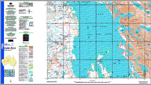
Lake Eyre 1-250,000 Topographic Map
$15.95 – $30.95
Description:
Locations within this Map
No 2 Dam The Warburton Groove Horseshoe Dam Fenner Depression Sunny Creek Ninety Nine Dam Palpalpa Hill Browns Creek Neales Overflow Yard Chincardina Waterhole Wadlalgla Hill Ballanuna Waterhole Jackboot Bay Level Post Bay Lake Mulapula Elliot Price Conservation Park Midway Dam Australia Betawappamuninbinna Waterhole Flint Mount Dam Armistice Bore Bandoo Hill No 3 Bore Silcrete Island Wildhorse Dam Lake Eyre National Park Yarra-Thungana No 1 Dam Bonython Headland Midla Milda Hill Willow Head Toongamoona Dam Artemia Point Piarooka Bore Skylark Dam Wadmatacunnieudinga Waterhole Victory Dam Hawken Creek Wangneerarangena Waterhole Neales River Nappamurra Black Arrow Dam Warmakidyaboo Hill Barlow Dam Halligan Bay Piarooka Hill Hambidge Point Babbage Peninsula Prescott Point Dulhunty Island Eric Island Kunoth Shoal Chincardina Creek Toongamoona Creek Wadmatagunnieudinga Waterhole Teemurrina Waterhole Cooper Inlet Campbell Point Palpalpa Swamp Piarooka Dam Barlow Creek Walpacunnia Waterhole Lake Koolkootinnie Brooks Island Lake Wadmadingalinda Hidden Valley Dam Victoria Creek Douglas Creek Up and Down Dam Warmakidyaboo Waterhole Barlow Waterholes Junction Gully Blanket Waterhole Nancy Bore Dividing Bluff Mercer Hill Callara Yard Oppathakana Waterhole Neales Overflow Hector Island Belt Bay Wandery Hill Breakthrough Gully Hunt Peninsula Coolibah Yard Kingoonaburrabinna Hill Packsaddle Dam The Douglas Flint Mound Cooinchina Creek Umbum Creek The Neales Madigan Gulf The Plains Trig Barcoo River Cooper Creek Lake Eyre North Sulphur Peninsula Scalloped Bay Mercers Hill Koolkootinnie Lake Midlamilda Hill The Warburton Kalaweerina Creek River Neales Warmakid Yaboo Hill The Plains Barcoo Creek Coopers Creek Number Two Dam Lake Eyre Kati-Tanda Number One Dam Coorichina Lake Wadmadingalinda Lake
| Name: | Lake Eyre |
| Publisher: | Geoscience Australia (Australian Government) |
| Scale: | 1:250000 |
| Latitude Range: | 28° 00.0′ S – 29° 0.0′ S |
| Longitude Range: | 136° 30.0′ E – 138° 0.0′ E |
| Projection / Datum: | Universal Transverse Mercator, GDA94 |
| Approx Print Size: | 0.44m X 0.67m |
| Publication Date: | 1-Jun-99 |


