


Liptrap 1-50,000 Vicmap
Price range: $12.00 through $24.00
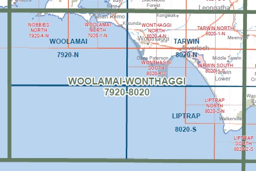
Description:
Liptrap 1-50,000 scale Victorian Topographical map 8020S is used for Walking, 4WD, Fishing, Camping, Motorcycle, both On and Off Road, Gold Prospecting and for those simply going for a family weekend drive.
Topographical maps show not only Contours of the Terrain but Walking Tracks, Sealed and Unsealed Roads, Rivers, Creeks, Lakes, Historical Point of Interest, Old Mine Sites mbtg and both National and State Park areas.
Main Features of this map includes:
Cape Liptrap, Cape Liptrap Lighthouse, Cape Liptrap Coastal Reserve, Maitland Beach, Bear Gully Campground, Grinder Point, m,btg, Liptrap, Lake POLTENEY, Walkerville, CAPE LIPTRAP Coastal Park, Arch Rock, Morgan Beach, Ten Mile Creek Mine, KINGS FLAT FR, WALKERVILLE COAST RESERVE, WALKERVILLE Caravan Park, Promontory View, Walkerville South
ISBN 9781742875170
You may also like…
-
Tarwin 1-50,000 Vicmap Topographical Map 8020-N
Price range: $14.00 through $26.00Select options This product has multiple variants. The options may be chosen on the product page -
LIPTRAP NORTH 1-25,000 Vicmap Topo Map 8020-2-N
Price range: $14.00 through $26.00Select options This product has multiple variants. The options may be chosen on the product page -
Andersons Inlet 1-25,000 Vicmap Topographic Map
Price range: $14.00 through $26.00Select options This product has multiple variants. The options may be chosen on the product page -
Darby 1-50,000 Vicmap
Price range: $12.00 through $24.00Select options This product has multiple variants. The options may be chosen on the product page -
Sale!
Vicmap South East Region Map Book Spatial Vision
Original price was: $95.00.$75.00Current price is: $75.00. -
South Gippsland Wilsons Promontory Map Rooftop
Price range: $11.95 through $25.00Select options This product has multiple variants. The options may be chosen on the product page -
Toora 1-50,000 Vicmap
Price range: $12.00 through $24.00Select options This product has multiple variants. The options may be chosen on the product page -
Warragul 1-250,000 Topographic Map
Price range: $15.95 through $30.95Select options This product has multiple variants. The options may be chosen on the product page -
LIPTRAP SOUTH 1-25,000 Vicmap Topo Map 8020-2-S
Price range: $14.00 through $26.00Select options This product has multiple variants. The options may be chosen on the product page