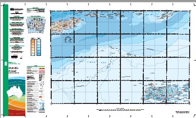
Melville Island 1-1,000,000 Topographic Map Geoscience Australia
Price range: $16.95 through $28.95
Description:
Melville Island 1-1,000,000 Topographic Map Geoscience Australia 1: 1 Million General Reference Topographic Map
Print on Demand
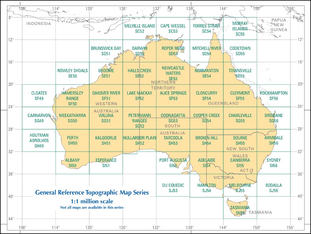
This map is part of a series which comprises 50 maps which covers the whole of Australia at a scale of 1:1 000 000 (1cm on a map represents 10km on the ground). Each standard map covers an area of 6 degrees longitude by 4 degrees latitude or about 590 kilometres east to west and about 440 kilometres from north to south. These maps depict natural and constructed features including transport infrastructure (roads, railway airports), hydrography, contours, hypsometric and bathymetric layers, localities and some administrative boundaries, making this a useful general reference map.
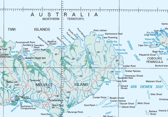
Goodrich Bank Lynedoch Shoal Lynedoch Bank Marie Reef Marie Shoal Milikapiti Snake Bay Nguiu Pirlangimpi Garden Point Bathurst Island Airfield Garden Point Aerodrome Rangku 4 Mile Camp Abbott Shoal Adbanae Afghan Shoal Alaru Creek Alawadna Jungle Alcaro Bay Allaru Island Andranangoo Creek Ant Cliff Apsley Strait Arangimpi Creek Araru Point Ardigbiyi Point Arluwampi Point Arrimu Creek Atauini Point Barbara Shoal Barlow Point Bath Creek Bathurst Island Bathurst Island Barge Landing Bathurst Trench Baxendell Reef Beagle Shoals Bill Shoal Black Rock Blue Mud Bay Bonkalji Beach Bonkalji Creek Boradi Bay Bowen Bay Brace Point Bremer River Brenton Bay Britarrimi Creek Brown Point Buchanan Island Bullabolla Creek Burford Island Burra Burra Head Cache Point Camp Point Cape Don Cape Don Airfield Cape Don Lighthouse Cape Fleeming Cape Fourcroy Cape Gambier Cape Helvetius Cape Keith Cape Lavery Cape Van Diemen castle Hill Caution Point / Pajuapura Christies Bay Christine Reef Clarence Strait Cleft Point Clift Island Cobham Bay Cobourg Peninsula Cockburn Sound Cockle Point Conder Point Cook Reef Craven Patches Culipurungini Creek Cullala Creek Curtis Haven De Vere Creek Deception Point Don Point Dongau Creek Dudwell Creek Dundas Strait Durham Point Elphinstone Reef Elsie Creek Eurumpanelli Creek Fitzpatrick Shoal Fletcher Point Fort Dundas Fuingatingerrany Creek Garden Point Garden Point Barge Landing Giles Shoal Goose Creek Gordon Bay Gordon Point Gullara Creek Harlock Point Harold Point Harris Island Harris Reef Herbert Point High Black Rock Hinkler Patches Hinxman Point Hunt Patch Hurd Point Ida Creek Indian Ocean Interview Point Ironstone Head Irrititu Island Jessie River Jikilijipinyapti Cliffs Johnson Point Johnston River Kanunga Point Karslake Island Kilimiraka Kilu-Impini Creek Kings Cove Kulaka-Iniarimu Creek Lamberts River Laxton Reef Lentherra Creek Lethbridge Bay Lingi Point Little Ginger Lubra Point Luxmore Head Maand Creek Maclear Creek Madford Shoals Malgrew Point Marloo Point Marralayangimpi Creek Martaboonga Creek Maruru Point Mataram Shoal Maxwell Creek Maxwell Creek Landing Ground Medina Inlet Melville Island Mermaid Shoal Mesquite Shoal Midjari Point Milikapiti Milikapiti Community Library Milikapiti Health Centre Milikapiti Hill Milikapiti Police Station Milikapiti Pre School Milikapiti Primary School Mintiluwu Creek Mirikau-Yunga Creek Mirrapoka Creek Mission Hill Mitchell Point Moanru Creek Moantu Moonga Hill Moonganunu Creek Moss Shoal Mount Hurd Mudlow Creek Mullalgah Waterhole Munanampi Creek Munanampi Point Munkunuwa Cliff Muranapi Point Murrow Point Napier Bay Newby Shoal Nguiu Community Health Centre Nguiu Police Station Nihill Patch Nodlaw Island North Channel North Ridge Notch Peak Ommaney Shoal Paddy Patches Parry Shoal Parsons Bank Paru Peaked Hill Pekiapauthera Creek Penguin Hill Perakery Creek Pickertaramoor PIckertaramoor Landing Ground Pimaroo Creek Pinyianappi Beach Piparto Creek Piper Head Pipianamili Creek Pirapillipoonga Creek Pirlangimpi Pirlangimpi Catholic Church Pirlangimpi Club Pirlangimpi Health Centre Pirlangimpi Police Station Point Byng Point Fawcett Point Jahleel Point Jual Point Punalli Point Strath Poonelli Popham Bay Port Cockburn Port Hurd Pramamee Creek Pukitiarmarloo Point Pularumpi School Pulloloo Bay Purninga Point Purputi Creek Purumpenelli Point Putjamirra Quanipiri Bay Radar Hill Radford Point Red Cliffs Renard Shoal Rinamatta Beach Robertson Creek Robinson Inlet Rocky Point Roe Point Saunders Creek Saunders Patch Shamrock Bay Shark Bay Shoal Bay Silvid Bay Sinclair Point Smoky Point Snake Bay Snake Bay Aerodrome Snake Bay Barge Landing Soldier Point St Asaph Bay Strath Sands Taiyuan Shoal Takamprimili Creek Takapimiliyi Tamar Point Tamratoarimu Creek Taracumbi Taradiri Creek Taylor Patches The Deep The Narrows Tientebei Beach Tinganoo Bay Tipabina Creek Tiwi Islands Tjipripu River Tjudu Creek Tominappi Creek Tregenna Reef Trepang Bay Tunganapu Creek Twin Cliffs Ungallalalla Creek Van Diemen Gulf Vashon Head Wal-e-ga Point Wanaraij Point Wanganui Rock Wangiti Beach Wanyanga Beach Warankuwu School Wells Shoal West Point Wirrianappi Creek Wirrunga Wiyapurali Wongaroo Point Woolunga Creek Wurankuwu Wurankuwu Airstrip Yauwalunga Point Yew Creek Yinanapi Point Yunanti Bay Lynedock Bank Cootamundra Shoal Calder Shoal Cape Van Dieman Yungereti Mud Bay Radford Shoals Purumpinelli Point Saint Asaph Bay Marloo Woolrungku Harrold Point Patchopra Point Deception Tuanungku River Bura Bura Head Murroo Point Wulumathera Bluewater Creek Aliu River Palawaeunga Bay Mirikau-yunga Creek Silvio Bay Caution Point Miungapukamu Gribbles Settlement Gribble Settlement Gwyneth Point Johnsons Point Tapar-arimi Minkau Putuwunni Creek Gullala Creek Gordan Point Kulaka-iniarimu Creek Euingatingerrany Creek Mioni Clift Islet Thiritji Creek Ommanney Shoals Ommaney Shoals Muripiunga Antrimpinyni Nimuapi Fort Hurd Euro Creek Renard Shoals Gordan Bay Mount Walter Perarkery Creek Morriu Point Mindelu Creek Jarnatuwu Tungandu Moantu Creek Mirialampi Creek Waniunga Beach Buchanan Islets Tangiau One Tree Point Bonkatji Creek Abbot Shoal Afgan Shoal Point Elly Flinders Shoal
| Name: | Melville Island |
| Publisher: | Geoscience Australia (Australian Government) |
| Scale: | 1:1000000 |
| Latitude Range: | 8° 0.0′ S – 12° 0.0′ S |
| Longitude Range: | 126° 0.0′ E – 132° 0.0′ E |
| Projection / Datum: | Lambert Conformal Conic, GDA94 |
| Approx Print Size: | 0.44m X 0.67m |
| Publication Date: | 2013 |