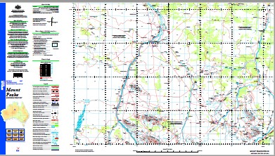
Mount Peake 1-250,000 Topographic Map
$15.95 – $30.95
Description:
Print on Demand
Locations within this Map
12 Mile Bore 18 Mile Bore 8 Mile Bore Ajax Bore Alpine Bore Amesbury Bore Anmatjere Anningie Anningie Airstrip Anningie Creek Anzac Dam Ardath Bore Barkly Bore Bau Range Bhp Bore Big Bore Bilba Hills Bloodwood Ennugan Creek Bloodwood Bore Bloodwood Creek Bloodwood Well Boko Bore Browns Yards Cave Well Central Mount Central Mount Stuart Central Mount Stuart Historical Reserve Central Mount Sturt Chu Chu Yard Cockatoo Creek Conical Hill Coron Bore Coronation Bore Crazy Creek Crows Nest Well Cultivation Bores Djilbari Hills Duck Hole Englands Well Ennugan Creek Esther Fotheringham Hill Four Mile Well Gettens Well Giles Range Ginger Hole Bore Gingers Waterhole Gremlin Bore H 198 Hanson Bore Hanson Yard Hoodoo Well Ingallan Creek Ingallana Bore Island Bore Johns Range Koonoonyeri Bore Leichardt Leichhardt Bore Leichhardt Spring Limestone Bore Little Bore Loora Creek Middle Well Midway Bore Mistake Bore Mortons Camp Yards Mount Barkly Mount Barkly Airstrip Mount Browne Mount Chisholm Mount Esther Mount Esther Dam Mount Esther Well & Bore Mount Judith Mount Judith Bore Mount Leichhardt Mount Parkinson Mount Peake Mount Peake 3 Bore Mount Peake Creek Mount Peake Creek Bore Mount Peake Dam Mount Rennie Mount Rennie Bore Mount Rennie Swamp Dam Mount Windajong Mud Hut Bore Mud Hut Well Mulyugaridji Hills Murray Creek Murray Creek Bore Murray Creek Dam Namga Range New Bore Ngandanjariwanu Swamp No 10 Bore No 11 Bore No 7 Bore No 8 Bore No 9 Bore North Bore North West Bore Old Mount Peake Homestead Paupers Well Petyale Pilooman Bore Possum Well Prosperity Bore Queensland Bore Redbank Bore Redhackle Dam Saddle Creek Saddle Hole Creek Saddle Hole Dam Salt Bore Salt Well Creek Sandford Bore Sapper Soak Bore Sheppwell Bore Smokey Bore Stock Agents Bore Stockyard Bore Stony Creek Studholme Hills Syphon Bore Tractor Waterhole Twin Soak Bore U 738 U 740 U 742 U 744 Vendetta Bore Viscount Bore Wailbry Well Walabanba Hills Walangawanu Hills Waldigalong Claypan Wanabanda Hills Western Bore Western Creek Western Creek Yard White Stone Well Wilgibanda Hill Willowra Willowra Aerodrome Willowra Police Station Willowra School Windjajong Bore Windjojo Bore Wini Hills Wirliyatjarra Health Centre Wollagalong Bore Wollagalonng Outstation Woodalla Bore Yindjirbi Range Yundurbulu Range Jarrah Jarrah Range Eight Mile Bore North Hill Walibry Well Fisher Creek Twelve Mile Bore Ingallana Creek Ingallanna Creek Number Eleven Bore Mount Peak Creek Bore Soda Creek Mount Leichardt Mount Denison Central Mountain Wodalla Bore Mount Stuart Anningie Waterhole
| Name: | Mount Peake |
| Publisher: | Geoscience Australia (Australian Government) |
| Scale: | 1:250000 |
| Latitude Range: | 21° 0.0′ S – 22° 0.0′ S |
| Longitude Range: | 132° 0.0′ E – 133° 30.0′ E |
| Projection / Datum: | Universal Transverse Mercator, GDA94 |
| Approx Print Size: | 0.44m X 0.67m |
| Publication Date: | 1-Jun-02 |


