
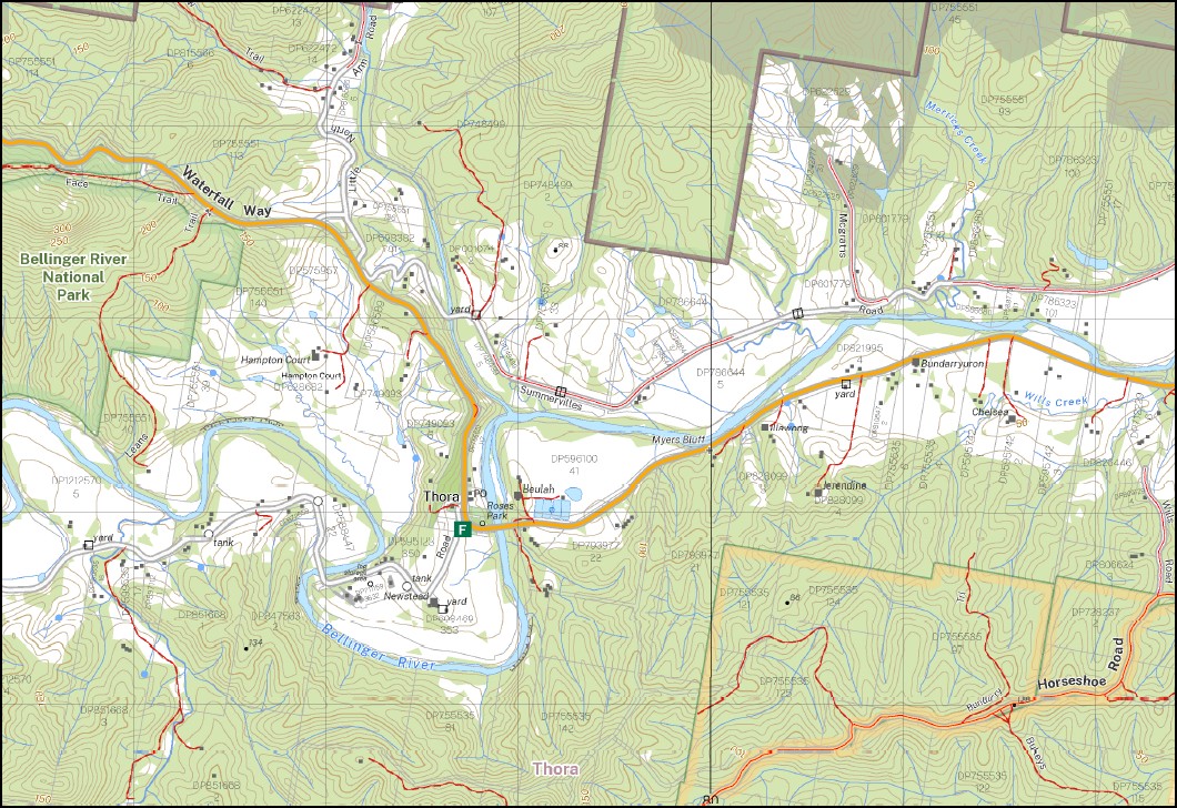
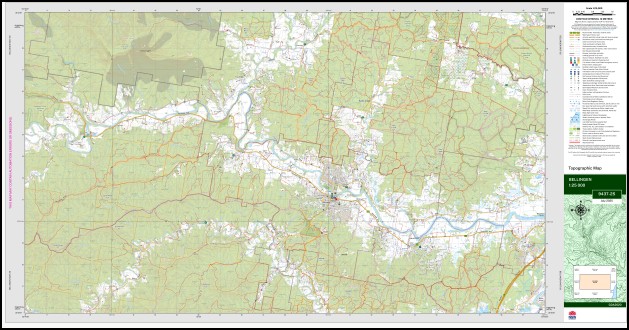
Bellingen 1-25,000 NSW Topographic Map 9437-2-S
Price range: $16.95 through $28.95
Description:
Bellingen 1-25,000 NSW Topographic Map 9437-2-S
Bellingen 94372s 1-25,000 scale NSW Topographical map is used for Walking, 4WD, Fishing, Camping, Motorcycle, both On and Off Road, Gold Prospecting and for those simply going for a family weekend drive.
Topographical maps show not only Contours of the Terrain but also Walking Tracks, Sealed and Unsealed Roads, Rivers, Creeks, Lakes, Historical Point of Interest, Old Mine Sites mbtg and National and State Park areas.
This map includes the following localities: Maydale Glen The Delwood Goldbrae Glenell Midway Minto Rosecliff Hillandale Norbank Abbey Farm Bonnie Doon Bellingen Bellingen High School Bellingen Lookout Bellingen Park Bellingen Post Office Bellingen Public School Bellinger River Belmore Bests Creek Bests Gully Billy Mcgraths Hump Blakes Gully Boggy Creek Brierfield Buffer Creek Buffers Creek Caines Hill Charlie Moodys Gully Charlmont Connell Creek Connell Park Connels Creek Dales Gully Fernmount Fernmount Cemetery Frenchmans Creek Gladstone Gladstone State Forest Gleniffer Gordonville Greers Flat Hampton Court Hubbards Peak Hydes Creek Irishman Ridge Jarrett Park Kalang River Keanes Hill Keough Reserve Charlie Moodys Creek Connells Creek Fernmount Range Gleniffer Public School Irishman Range Keanes Mountain Kooroowi Little Boggy Creek Little North Arm Bellingen River Little Pine Creek Lookout Lookout Hill Mount Lookout Lovells Hill Mcgraths Hump Mahers Creek Marx Hill Merricks Creek Mitchells Hill Moodys Creek Moodys Hill Muddy Road Hill Myers Bluff Never Never State Fotest Newell Falls North Arm Bellinger River North Bellingen Raymond Creek Raymonds Creek Raymonds Gully Reids Creek Roses Creek Rosewood Creek Rosewood River Rotary Lookout Sackmans Gully Scotchman Scotchman Range Scotchman State Forest Seaview Seaview Hill Smiths Hill South Arm Bellingen River South Bellingen Stony Creek Stony Gully Summervilles Creek Sunny Corner Sunny Corner Creek Tarkeeth Public School Taylors Gully mbtg Thora Valery Wattle Hill Weekes Weekes Cemetery Wells Creek Wills Creek Woods Creek Woutis Bluff Dingle Dingle Gully Youngers Creek Dorrigo National Park Dingle Creek Dorrigo State Park Burdett Park Creek Fig Tree Reserve Tarkeeth State Forest Samuel Joyce Reserve Raleigh Lovell Gully George Edmunds Reserve
| Scale: | 1:25,000 |
| Latitude Range: | 30 22.5 S – 30 30.0 S |
| Longitude Range: | 152 45.0 E – 153 00.0 E |
| Approx Print Size: | 0.56m X 1.11m |
| Projection: | Transverse Mercator
GDA 2020 Edition 2025 |
You may also like…
-
Brooklana 1-25,000 NSW Topographic Map 9437-2-N
Price range: $16.95 through $28.95Select options This product has multiple variants. The options may be chosen on the product page -
Glenreagh 1-25,000 NSW Topographic Map 9437-1-N
Price range: $16.95 through $28.95Select options This product has multiple variants. The options may be chosen on the product page -
Raleigh 1-25,000 NSW Topographic Map 9537-3-S
Price range: $16.95 through $28.95Select options This product has multiple variants. The options may be chosen on the product page -
Dorrigo 1-25,000 NSW Topographic Map 9437-3-N
Price range: $16.95 through $28.95Select options This product has multiple variants. The options may be chosen on the product page -
Missabotti 1-25,000 NSW Topographic Map 9436-1-N
Price range: $16.95 through $28.95Select options This product has multiple variants. The options may be chosen on the product page