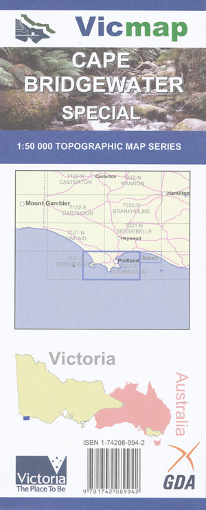
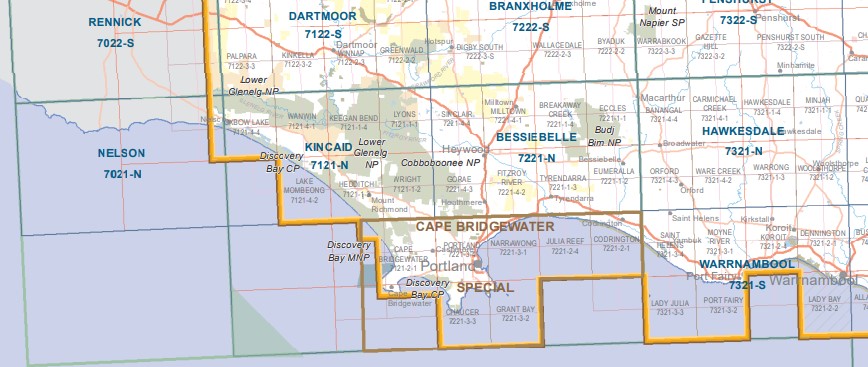
Cape Bridgewater Special 1-50,000 Vicmap
Price range: $12.00 through $24.00
Description:
Cape Bridgewater Special 1-50,000 scale Vicmap Topographical map is used for Walking, 4WD, Fishing, Camping, Motorcycle, both On and Off Road, Gold Prospecting and for those simply going for a family weekend drive.
Topographical maps show not only Contours of the Terrain but Walking Tracks, Sealed and Unsealed Roads, Rivers, Creeks, Lakes, Historical Point of Interest, Old Mine mbtg Sites and National and State Park areas.
Main Features of this map includes:
Portland, Cape Bridgewater, Cape Nelson, Discovery Bay Coastal Park, Parts of the Great South West Walk, Cashmore, Tarragal, Discovery Bay CP, Mount Richmond NP, Benwerrin Walk, Bridgewater Track, Noels Walk, Ocean View Walk, Alecs Walk, South Fireline Track, South Boundary Track, mbtg, Blackers Track, Malseeds Swamp, Mortons, part of the Great South West Walk, Sandy Waterhole, Emu Hill Waterhole, Curries, Hanns Track, Knights Swamp, Bridgewater Lake, Bridgewater Caves, Mount Dryden, Whites Beach, Lower Cape Bridgewater, mbtg, Bats Ridge WR, part of the Great South West Walk, Trewalla Camp Track, Shelly Beach, Bridgewater Bay, Fisherman Cove, MBTG, Discovery Bay CP, The Blowholes Lookout, Cape Duquesne, Perilous Parapet, Cape Bridgewater Lookout, Fisherman Cove
Portland, Portland North, Portland West, Allestree, Bolwarra, Cashmore, Trewalla, Cobboboonee Forest Park, Narrawong Coast Res, Narrawong Beach, part of the South West Walk, Anderson Point, Whalers Bluff Lighthouse, Observatory Point, Observatory Hill, Whalers Point, Fawthrop Lagoon, Nuns Beach, Bats Ridge, Discovery Bay CP, mbtg, Mount Chaucer, Discovery Bay CP, Enchanted Forest Lookout Platform, Yellow Rock Lookout, Nelson Bay Coast Res, Blacknose Point, Point Danger, Cape Sir William Grant, mbtg, Eastern Rampart Lookout Platform, Picnic Hill, Cape Nelson, Cliff Nature Walk, Cape Nelson Lightstation, Great South West Walk. Cape Nelson Lighthouse Walk, Lawrence Rocks WR.
You may also like…
-
PORTLAND NORTH 1-25,000 Vicmap Topo Map 7221-3-N
Price range: $14.00 through $26.00Select options This product has multiple variants. The options may be chosen on the product page -
BRIDGEWATER SOUTH 1-25,000 Vicmap Topo 7121-2-S
Price range: $14.00 through $26.00Select options This product has multiple variants. The options may be chosen on the product page -
BRIDGEWATER NORTH 1-25,000 Vicmap Topo 7121-2-N
Price range: $14.00 through $26.00Select options This product has multiple variants. The options may be chosen on the product page -
Kincaid 1-50,000 Vicmap
Price range: $12.00 through $24.00Select options This product has multiple variants. The options may be chosen on the product page -
Warrnambool 1-50,000 Vicmap
Price range: $12.00 through $24.00Select options This product has multiple variants. The options may be chosen on the product page -
PORTLAND SOUTH 1-25,000 Vicmap Topo Map 7221-3-S
Price range: $14.00 through $26.00Select options This product has multiple variants. The options may be chosen on the product page -
Nelson Portland Vicmap 1-100,000 Topo 7121-7221
Price range: $12.00 through $24.00Select options This product has multiple variants. The options may be chosen on the product page -
Bessiebelle 1-50,000 Vicmap
Price range: $12.00 through $24.00Select options This product has multiple variants. The options may be chosen on the product page