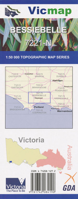
Bessiebelle 1-50,000 Vicmap
Price range: $12.00 through $24.00
Description:
Bessiebelle 1-50,000 scale Vicmap Topographical map 7221N is used for Walking, 4WD, Fishing, Camping, Motorcycle, both On and Off Road, Gold Prospecting and for those simply going for a family weekend drive.
Topographical maps show not only Contours of the Terrain but Walking Tracks, Sealed and Unsealed Roads, Rivers, Creeks, Lakes, Historical Point of Interest, Old Mine Sites mbtg and National and State Park areas.
Main Features of this map includes:
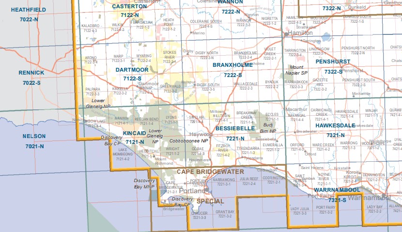
Macarthur, Ardonachie, Dunmore BR, Allambie Camp, Breakaway Creek, Stony Rises, Breakfast Creek, Hicks Hill, Budj Bim NP, Budj Bim Campground, Old Lava Canal, East West Seismic Track, Whittlebury Swamp, Condah Mission, Lake Condah, Murphys Hut Camp, mbtg, Vaughan Buffer Track, Nelsons Track, Little Mount, Lake Surprise, Addinsalls Pit, Old Volcanic Vents, Mount Eccles Pit Site, Natural Bridge, Gorrie Swamp, Brand Track, The Stones Reference Area, Homerton SF, Condah South, Lake Gorrie Camp, mbtg, Bessiebelle, Homerton, Tyrendarra, Tyrendarra East, Budj Bim NP, Dunmore SF, Purcell Track, Stony Rises, Kurtonitj Indigenous Protected Area, Tyrendarra Indigenous Protected Area, Bessiebelle Recreation Reserve, White Elephant Bridge, Overflow Bridge, mbtg, Rowbottoms Bridge, Purcell Bridge, Lindsey Bridge, Homerton Swamp, Narrawong East, Fitzroy River Picnic Area, Bessiebelle SF, Watts Bridge, Crowes Hill, Tyrendarra FR, Fitzroy River SSR.
Annya, Myamyn, Milltown, Drumborg, West Sinclair, Annya SF, Springburn Creek, Annya Swamp, Sheoak Rise, Whittlebury Creek, Malseeds Plantation, Whittlebury Swamp, Slater Plantation, mbtg, Gorrie Hill, Dingo Dell Swamp, Never Never Swamp, Boggy Swamp, Drumborg BR, Dye Swamp, Lake Sinclair WR, Hunter Creek, Sunday Creek, Rotten Swamp, Milltown SF, Mount Eckersley, mbtg, Porter Plantation, Sugarloaf Hill, Washpool Creek, Wild Dog Swamp, The Dough Boy, Corduroy Creek, Kangaroo Hill, Homerton SF, Goose Lagoon, Fitzroy River, Heywood, Cave Hill, Heathmere, Scrubbers Creek, Turley Swamp, Goose Lagoon, Pinewood Caravan Park, Homerton SF, Stony Rises, mbtg, Sandy Creek, Red Creek, part of Cobboboonee Forest Park, Cobboboonee NP, part of the Great South West Walk, Peat Swamp, Wild Dog Creek, Cobboboonee Horse Trail, Odgetts Loop Walk, Narrawong FR, Mt Clay SF, Sandy Creek, Narrawong East, mbtg, Mount Clay Fire Lookout, Saw Pit Picnic Area, Whalers Lookout, Mountain Bike Track, The Woolwash, Nine Mile FFR, Heathmere Flora & Fauna Reserve, Wild Dog Creek.
ISBN 9781742084190
You may also like…
-
Hawkesdale 1-50,000 Vicmap
Price range: $12.00 through $24.00Select options This product has multiple variants. The options may be chosen on the product page -
HEYWOOD NORTH 1-25,000 Vicmap Topo Map 7221-4-N
Price range: $14.00 through $26.00Select options This product has multiple variants. The options may be chosen on the product page -
BESSIEBELLE NORTH 1-25,000 Vicmap Topo 7221-1-N
Price range: $14.00 through $26.00Select options This product has multiple variants. The options may be chosen on the product page -
Warrnambool 1-50,000 Vicmap
Price range: $12.00 through $24.00Select options This product has multiple variants. The options may be chosen on the product page -
BESSIEBELLE SOUTH 1-25,000 Vicmap Topo 7221-1-S
Price range: $14.00 through $26.00Select options This product has multiple variants. The options may be chosen on the product page -
Hamilton Special 1-250,000 Topographic Map
Price range: $15.95 through $30.95Select options This product has multiple variants. The options may be chosen on the product page -
Kincaid 1-50,000 Vicmap
Price range: $12.00 through $24.00Select options This product has multiple variants. The options may be chosen on the product page -
Penshurst 1-50,000 Vicmap
Price range: $12.00 through $24.00Select options This product has multiple variants. The options may be chosen on the product page -
HEYWOOD SOUTH 1-25,000 Vicmap Topo Map 7221-4-S
Price range: $14.00 through $26.00Select options This product has multiple variants. The options may be chosen on the product page -
Dartmoor 1-50,000 Vicmap
Price range: $12.00 through $24.00Select options This product has multiple variants. The options may be chosen on the product page -
Branxholme 1-50,000 Vicmap
Price range: $12.00 through $24.00Select options This product has multiple variants. The options may be chosen on the product page -
Cape Bridgewater Special 1-50,000 Vicmap
Price range: $12.00 through $24.00Select options This product has multiple variants. The options may be chosen on the product page