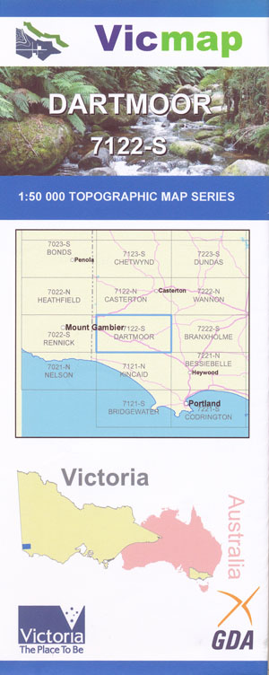
Dartmoor 1-50,000 Vicmap
Price range: $12.00 through $24.00
Description:
Dartmoor 1-50,000 scale Vicmap Topographical map 7122S is used for Walking, 4WD, Fishing, Camping, Motorcycle, both On and Off Road, Gold Prospecting and for those simply going for a family weekend drive.
Topographical maps show not only Contours of the Terrain but Walking Tracks, Sealed and Unsealed Roads, Rivers, Creeks, Lakes, Historical Point of Interest, Old Mine Sites mbtg and National and State Park areas.
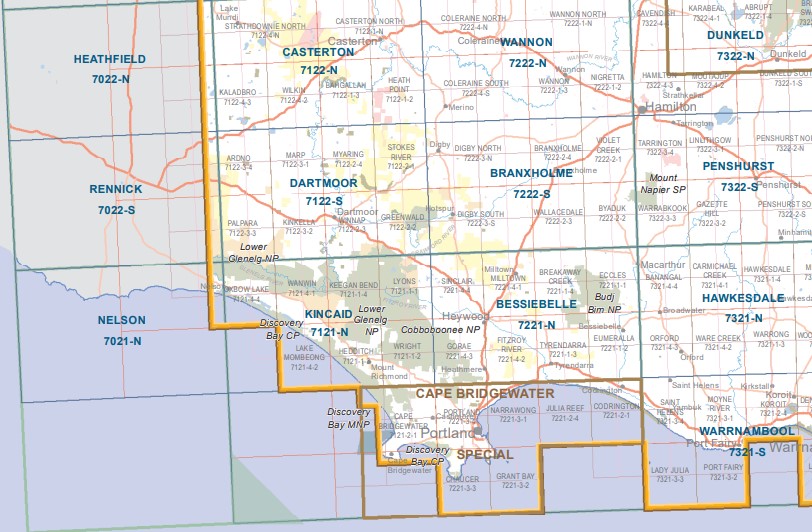
Main Features of this map include:
Dartmoor
Glenelg River from Keegans Bend to Wilkin Forest in the north
Part of the Glenelg River, Stokes River, Stokes River State Forest, Red Hill Swamp, PIERACLE SWAMP Wilderness Reserve, Weecurra State Forest, Winnap State Forest, Teakettle Creek, mbtg, Tin Hut Swamp, Gibsons Hill, Lane Plantation, Mocamboro State Forest, Hotspur State Forest, Wataepoolan State Forest mbth Dartmoor, Glenelg River, Part of the Glenelg River, Bird Bath Wayside Stop, Bucknall Falls, LOWER GLENELG National Park, COBBOBOONEE National Park, Drik Drik, Winnap, Smokey River Caravan Park, mbtg, Winnap Station disused, Stokes Bridge, Stokes Rive, Blackfish Swamp, BURGESS SWAMP Wilderness Region, Emmerson Plantation, Bacci Creek, Seventeen Mile Crossing, Greenwald, Greenwald Station Disused, Camp Corner, Winnap State Forest, Wataepoolan State Forest, Lake Crwaford, Smokey Valley Plantation, Hotspur State Foerest, Hiscocks Crossing, Glenaulin, Lower Crawford, Crawford River, Hiscocks Crossing, Annya State Forest
ISBN 9781742084619
You may also like…
-
DARTMOOR SOUTH 1-25,000 Vicmap Topo Map 7122-2-S
Price range: $14.00 through $26.00Select options This product has multiple variants. The options may be chosen on the product page -
DARTMOOR NORTH 1-25,000 Vicmap Topo Map 7122-2-N
Price range: $14.00 through $26.00Select options This product has multiple variants. The options may be chosen on the product page -
Cape Bridgewater Special 1-50,000 Vicmap
Price range: $12.00 through $24.00Select options This product has multiple variants. The options may be chosen on the product page -
Bessiebelle 1-50,000 Vicmap
Price range: $12.00 through $24.00Select options This product has multiple variants. The options may be chosen on the product page -
Rennick 1-50,000 Vicmap
Price range: $12.00 through $24.00Select options This product has multiple variants. The options may be chosen on the product page -
Casterton 1-50,000 Vicmap
Price range: $12.00 through $24.00Select options This product has multiple variants. The options may be chosen on the product page -
Nelson 1-50,000 Vicmap
Price range: $12.00 through $24.00Select options This product has multiple variants. The options may be chosen on the product page -
Kincaid 1-50,000 Vicmap
Price range: $12.00 through $24.00Select options This product has multiple variants. The options may be chosen on the product page -
Branxholme 1-50,000 Vicmap
Price range: $12.00 through $24.00Select options This product has multiple variants. The options may be chosen on the product page