
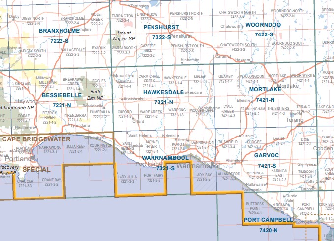
Hawkesdale 1-50,000 Vicmap
Price range: $12.00 through $24.00
Description:
Hawkesdale 1-50,000 scale Vicmap Topographical map 7321N is used for Walking, 4WD, Fishing, Camping, Motorcycle, both On and Off Road, Gold Prospecting and for those simply going for a family weekend drive.
Topographical maps show not only Contours of the Terrain but Walking Tracks, Sealed and Unsealed Roads, Rivers, Creeks, Lakes, Historical Point of Interest, Old Mine Sites and National and State Park areas.
Main Features of this map include:
The towns of Hawkesdale, MacArthur, Orford, Woolsthorpe, Minjah, Lake Buttabool, Lake Minhamite, Lochaber Gully, Black Swamp, Goodwood Bridge, Whiteheads Creek, Whiteheads Bridge, Warburtons Creek, Lochaber Gully, mbtg, Hopetoun Channel, Kangertong Bridge, Noonans Bridge, Nardoo Bridge, Nardoo Creek, Obriens Bridge, Gipsy Creek, Quamby Bridge, Youl Creek, mbtg, Willatook, Nardoo Creek, Arnolds Bridge, Austins Creek, Gipsys Creek, Kennedy Creek, Wild Dog Creek, mbtg, Wild Dog Swamp, Sandy Creek, Swarbricks Bridge, Farleys Bridge, Threlfalls Bridge, Blackwood Creek, Union Creek, Bullanbul Creek, Lake Cartgarrong, Kia-Ora Bridge, Taurus Mount, Murray Brook.
Macarthur, Ripponhurst, Hawkesdale West, Breakfast Creek, Farmers Creek, Judy Creek, Grassy Gully Creek, Ripponhurst Bridge, Blackfellows Bridge, Shaw River, Moyne Falls, Lake Buttabool, Breakfast Creek Bridge, Eumeralla, Carmichael Creek, Kangaroo Creek, Snakey Creek, Gorrie Swamp, Second Bar Bridge, Dog Hole Bridge, Deep Creek, Broadwater. mbtg,
Tarrone, Orford, Broadwater, Dunmore, Dunmore Bridge, Kangaroo Creek, Cockatoo Swamp, Paradise Bridge, Daisy Dell Bridge, Willatook, Bartlett Swamp, Smyths Bridge, Threlfalls Bridge, mbtg, Wild Dog Creek, Tarrone Bridge, McKinleys Bridge, Lewis Bridge, St Helens FR, Pretty Hill FR.
ISBN 9781742084930
You may also like…
-
Otways West Shipwreck Coast Map Spatial Vision
Price range: $13.95 through $28.95Select options This product has multiple variants. The options may be chosen on the product page -
Bessiebelle 1-50,000 Vicmap
Price range: $12.00 through $24.00Select options This product has multiple variants. The options may be chosen on the product page -
Warrnambool 1-50,000 Vicmap
Price range: $12.00 through $24.00Select options This product has multiple variants. The options may be chosen on the product page -
HAWKESDALE SOUTH 1-25,000 Vicmap Topo 7321-1-S
Price range: $14.00 through $26.00Select options This product has multiple variants. The options may be chosen on the product page -
MACARTHUR SOUTH 1-25,000 Vicmap Topo Map 7321-4-S
Price range: $14.00 through $26.00Select options This product has multiple variants. The options may be chosen on the product page -
MACARTHUR NORTH 1-25,000 Vicmap Topo Map 7321-4-N
Price range: $14.00 through $26.00Select options This product has multiple variants. The options may be chosen on the product page -
HAWKESDALE NORTH 1-25,000 Vicmap Topo 7321-1-N
Price range: $14.00 through $26.00Select options This product has multiple variants. The options may be chosen on the product page